File:Regiones.militares.arg.1905.jpg

Archivo original (2332 × 3453 píxeles; tamaño de archivo: 1003 kB; tipo MIME: image/jpeg)
Leyendas
Leyendas
| Descripción |
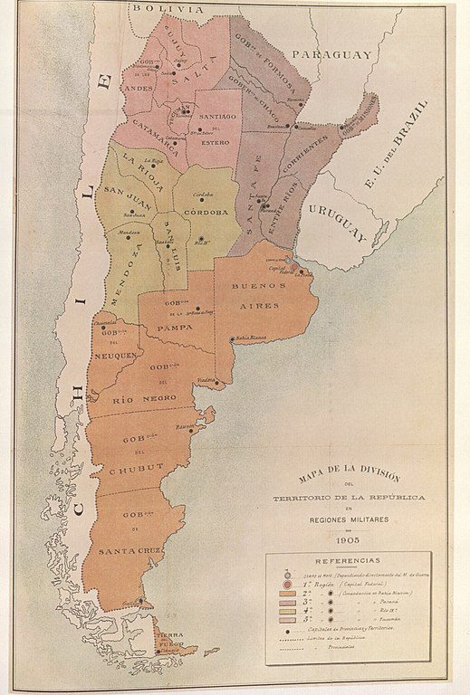
"This reproduction of the map 'Map of the division of the Argentine territory into Military regions 1905' was included in the Military Bulletin of the Argentine Minestry of War, Year IV, vol. I, 1 May 1905, No. 140. The argentine military regions are distinguished by different colours, all territories located south of the Beagle Channel as far as Cape Horn been omitted and thus understood to be under Chilean sovereignty." " |
||||
| Fecha | |||||
| Fuente | El Conflicto del Beagle, edited by the chilean Foreign Affairs Office, 1978, Switzerland. | ||||
| Autor | Desconocido | ||||
| Permiso (Reutilización de este archivo) |
|
||||
Historial del archivo
Haz clic sobre una fecha y hora para ver el archivo tal como apareció en ese momento.
| Fecha y hora | Miniatura | Dimensiones | Usuario | Comentario | |
|---|---|---|---|---|---|
| actual | 15:00 19 ago 2007 | | 2332 × 3453 (1003 kB) | Keysanger (discusión | contribs.) | {{Information |Description="This reproduction of the map 'Map of the division of the Argentine territory into Military regions 1905' was included in the Military Bulletin of the Argentine Minestry of War, Year IV, vol. I, 1 May 1905, No. 140. The argentin |
No puedes sobrescribir este archivo.
Usos del archivo
No hay páginas que enlacen a este archivo.
Uso global del archivo
Las wikis siguientes utilizan este archivo:
- Uso en de.wikipedia.org
- Uso en de.wikisource.org
- Uso en en.wikipedia.org
- Uso en es.wikipedia.org
- Uso en fr.wikipedia.org