File:Reims — Plan du guide Baedeker de 1908 (01).jpg
Jump to navigation
Jump to search
Size of this preview: 449 × 600 pixels. Other resolutions: 180 × 240 pixels | 359 × 480 pixels | 575 × 768 pixels | 767 × 1,024 pixels | 1,533 × 2,048 pixels | 3,166 × 4,228 pixels.
Original file (3,166 × 4,228 pixels, file size: 6.22 MB, MIME type: image/jpeg)
Captions
Captions
Add a one-line explanation of what this file represents
Summary[edit]
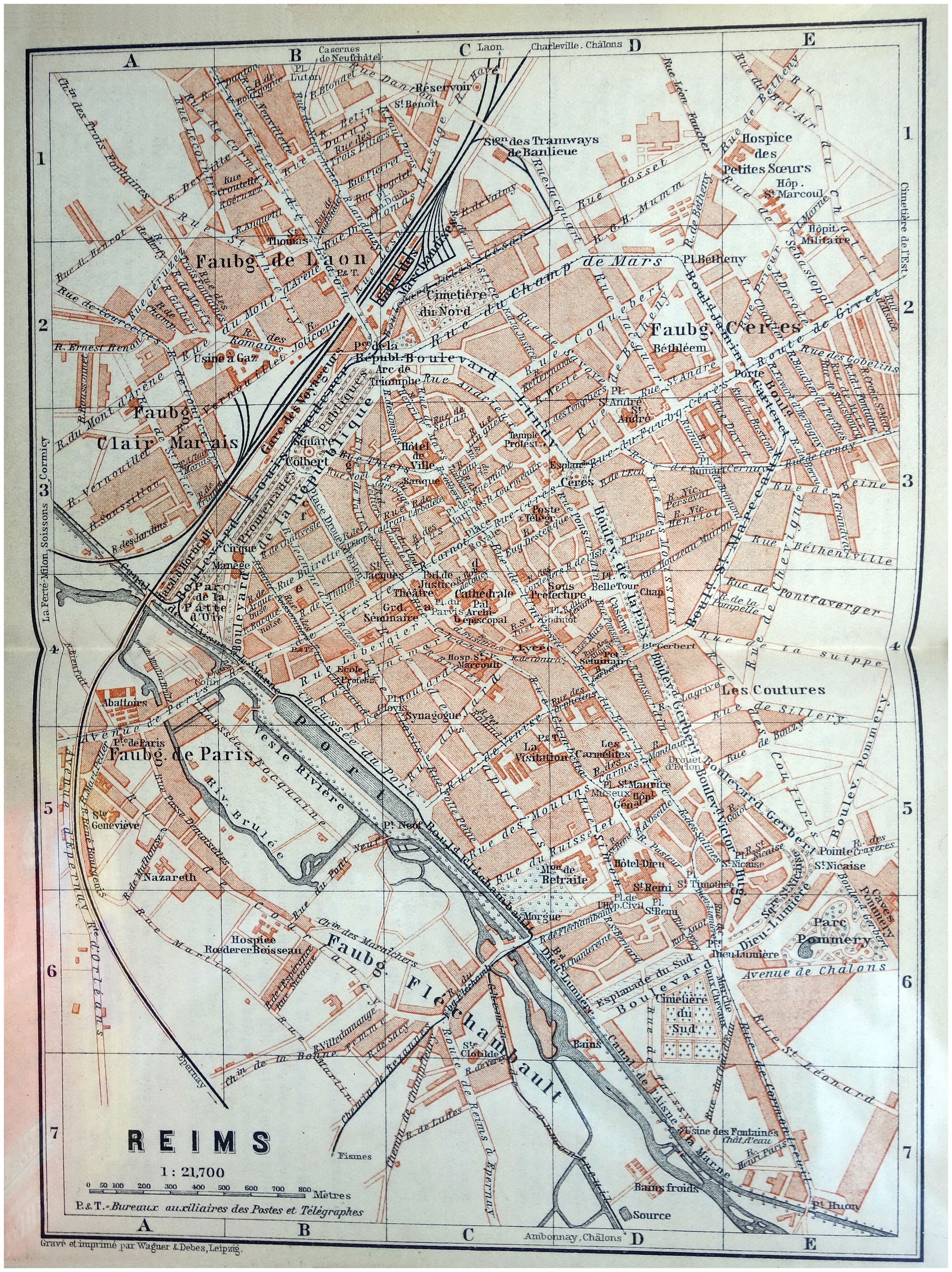
| Description |
Français : Plan de la Ville de Reims (France - dép. de la Marne) — Guide Baedeker de 1908 |
| Date | |
| Source | Collection personnelle |
| Author |
"Baedeker Nord-Est De La France". Édition de 1908 Geograph. Anstalt von Wagner & Debes, Leipzig. / Gravé et imprimé par Wagner & Debes, Leipzig. |
| Other versions |
_(rue_Simon).jpg)
_(rue_Universit%C3%A9).jpg)
_(rue_romains).jpg)
_(mont_d%27arene).jpg)
_(temple_linguet).jpg)
_(rue_belin).jpg)
_(arbalete_salin).jpg)
.jpg)
.jpg&action=edit§ion=1)
| Camera location | | View this and other nearby images on: OpenStreetMap |
|---|
.jpg¶ms=049.250000_N_0004.033000_E_globe:Earth_type:camera__&language=en)
Licensing[edit]
.jpg&action=edit§ion=2)
|
This work is in the public domain in its country of origin and other countries and areas where the copyright term is the author's life plus 70 years or fewer. This work is in the public domain in the United States because it was published (or registered with the U.S. Copyright Office) before January 1, 1929. | |
| This file has been identified as being free of known restrictions under copyright law, including all related and neighboring rights. | |
File history
Click on a date/time to view the file as it appeared at that time.
| Date/Time | Thumbnail | Dimensions | User | Comment | |
|---|---|---|---|---|---|
| current | 12:12, 10 October 2019 | | 3,166 × 4,228 (6.22 MB) | Jpcuvelier (talk | contribs) | User created page with UploadWizard |
You cannot overwrite this file.
File usage on Commons
The following 9 pages use this file:
- User:Christian1985/Mittelrhein/2019 October 1-10
- File:Reims — Plan du guide Baedeker de 1908 (01) (arbalete salin).jpg
- File:Reims — Plan du guide Baedeker de 1908 (01) (mont d'arene).jpg
- File:Reims — Plan du guide Baedeker de 1908 (01) (rue Simon).jpg
- File:Reims — Plan du guide Baedeker de 1908 (01) (rue Université).jpg
- File:Reims — Plan du guide Baedeker de 1908 (01) (rue belin).jpg
- File:Reims — Plan du guide Baedeker de 1908 (01) (rue romains).jpg
- File:Reims — Plan du guide Baedeker de 1908 (01) (temple linguet).jpg
- File:Reims — Plan du guide Baedeker de 1908 (courlancy).jpg
.jpg&oldid=867172651)