File:Relief Map of Brazil -borders.svg

Original file (SVG file, nominally 1,200 × 1,186 pixels, file size: 2.01 MB)
Captions
Captions
Summary[edit]
| Description |
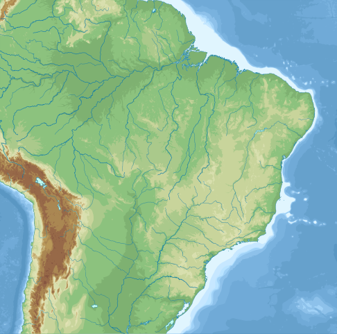
English: Topographic map of Brazil.
Equirectangular projection, N/S stretching 105%. Limits of the map :
Elevation of contour lines : -5000m (dark blue), -4000m, -3000m, -2000m, -1000m (light blue), -500m, -200m, -100m (bluish white), 0m (dark green), 100m, 300m (pale green), 500m, 1000m (yellow), 1500m, 2000m, 2500m (orange), 3000m, 4000m, 5000m (dark red) Other versions of this file : Français : Carte topographique du Brésil.
Projection cylindrique équidistante, étirement N/S 105%. Limites de la carte :
Altitude des courbes de niveau : -5000m (bleu foncé), -4000m, -3000m, -2000m, -1000m (bleu clair), -500m, -200m, -100m (blanc bleuté), 0m (vert foncé), 100m, 300m (vert pâle), 500m, 1000m (jaune), 1500m, 2000m, 2500m (orange), 3000m, 4000m, 5000m (rouge sombre) Autres versions de ce fichier : |
| Date | |
| Source |
|
| Author |
|
Licensing[edit]
- You are free:
- to share – to copy, distribute and transmit the work
- to remix – to adapt the work
- Under the following conditions:
- attribution – You must give appropriate credit, provide a link to the license, and indicate if changes were made. You may do so in any reasonable manner, but not in any way that suggests the licensor endorses you or your use.
- share alike – If you remix, transform, or build upon the material, you must distribute your contributions under the same or compatible license as the original.
File history
Click on a date/time to view the file as it appeared at that time.
| Date/Time | Thumbnail | Dimensions | User | Comment | |
|---|---|---|---|---|---|
| current | 16:32, 5 September 2021 | | 1,200 × 1,186 (2.01 MB) | Infomase (talk | contribs) | Uploaded a work by * File:Brazil_location_map.svg : User:NordNordWest * Derivative work : User:Infomase from * File:Brazil_location_map.svg : country and state borders, coastline, lakes, some rivers * [https://github.com/nvkelso/natural-earth-vector/ Natural Earth] (public domain) : more rivers * [https://www.gebco.net/data_and_products/gridded_bathymetry_data/ The GEBCO Grid 2020] (public domain) : topography and bathymetry, cropped and traced to SVG using OpenEV + Potr... |
You cannot overwrite this file.
File usage on Commons
There are no pages that use this file.