File:Relief Yakutia.png
Jump to navigation
Jump to search
Size of this preview: 647 × 599 pixels. Other resolutions: 259 × 240 pixels | 518 × 480 pixels | 923 × 855 pixels.
Original file (923 × 855 pixels, file size: 1.78 MB, MIME type: image/png)
Captions
Captions
Add a one-line explanation of what this file represents
Summary
[edit]
| Description |
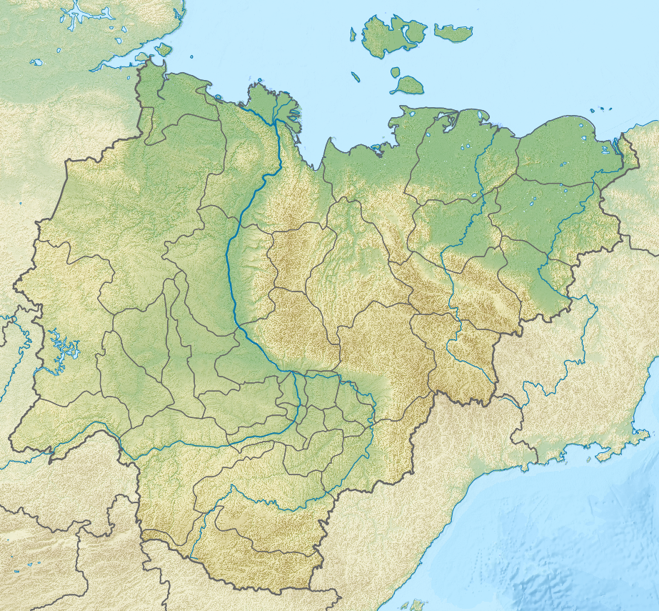
Русский: Физическая карта Якутии, Россия. |
| Date | |
| Source |
|
| Creator | |
| Geotemporal data | |
| Spatial reference system |
Русский: * Проекция: Коническая равнопромежуточная проекция, параметры проекции подобраны под File:Yakutia notext.svg
|
| Georeferencing | If inappropriate please set warp_status = skip to hide. |
Licensing
[edit]
I, the copyright holder of this work, hereby publish it under the following license:
This file is licensed under the Creative Commons Attribution-Share Alike 3.0 Unported license.
- You are free:
- to share – to copy, distribute and transmit the work
- to remix – to adapt the work
- Under the following conditions:
- attribution – You must give appropriate credit, provide a link to the license, and indicate if changes were made. You may do so in any reasonable manner, but not in any way that suggests the licensor endorses you or your use.
- share alike – If you remix, transform, or build upon the material, you must distribute your contributions under the same or compatible license as the original.
File history
Click on a date/time to view the file as it appeared at that time.
| Date/Time | Thumbnail | Dimensions | User | Comment | |
|---|---|---|---|---|---|
| current | 18:55, 28 March 2013 | | 923 × 855 (1.78 MB) | Nzeemin (talk | contribs) | Water colors fixed |
| 10:22, 31 March 2012 |  | 923 × 855 (1.77 MB) | Nzeemin (talk | contribs) | removed thick border on coastline | |
| 19:34, 16 March 2012 |  | 923 × 855 (1.77 MB) | Nzeemin (talk | contribs) |
You cannot overwrite this file.
File usage
There are no pages that use this file.
Global file usage
The following other wikis use this file:
- Usage on arz.wikipedia.org
- Usage on az.wikipedia.org
- Şablon:Kömür yatağı
- Şablon:Kömür yatağı/doc
- Şablon:Yer xəritəsi Rusiya Yakutiya
- Şərqi Sibir dənizi
- Laptevlər dənizi
- Yeni Sibir
- Kotelnı (ada)
- Bennett adası
- Yaya (ada)
- Vasilevski adası
- Kolesovski
- Kolesovskaya Otmel
- Vilkiski adası
- Belkovski adası
- Stolbovoy (ada)
- Henriett adası
- Semyonovski adası
- Jeleznyakov adası
- Kotordır
- Matar
- Nanosnıy adası
- Skrıtıy adası
- Tas-Arı adası
- Posadnıy
- Diomid
- Lısov adası
- Andreyev adası
- Puşkaryov adası
- Joxov
- Krestovski adası
- Çetıryoxstolbovoy (ada)
- Makar adası
- Orto-Arı
- Daqdalax
- Yarok adası
- Böyük Beqiçev
- Kiçik Beqiçev
- Muostax adası
View more global usage of this file.