File:República Federal de los Incas.svg
Jump to navigation
Jump to search

Size of this PNG preview of this SVG file: 531 × 599 pixels. Other resolutions: 213 × 240 pixels | 425 × 480 pixels | 680 × 768 pixels | 907 × 1,024 pixels | 1,814 × 2,048 pixels | 2,072 × 2,339 pixels.
Original file (SVG file, nominally 2,072 × 2,339 pixels, file size: 2.09 MB)
Captions
Captions
Add a one-line explanation of what this file represents
Summary
[edit]
| Description |
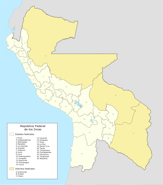
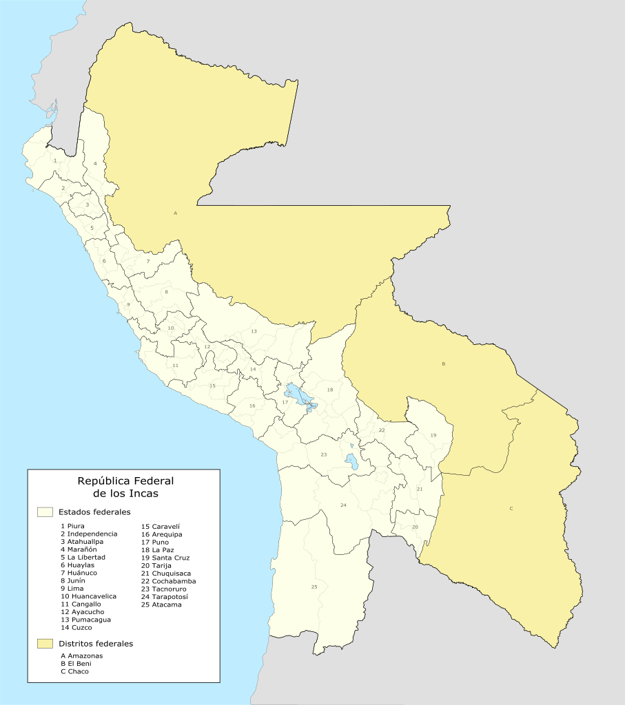
Español: Mapa de la reforma territorial que hubiera ocurrido de haber prosperado el proyecto de los Estados Unidos Perú-Bolivianos o República Federal de los Incas. |
| Date | |
| Source | Own work |
| Author | ARPS123 |
Licensing
[edit]
I, the copyright holder of this work, hereby publish it under the following license:
This file is licensed under the Creative Commons Attribution-Share Alike 4.0 International license.
- You are free:
- to share – to copy, distribute and transmit the work
- to remix – to adapt the work
- Under the following conditions:
- attribution – You must give appropriate credit, provide a link to the license, and indicate if changes were made. You may do so in any reasonable manner, but not in any way that suggests the licensor endorses you or your use.
- share alike – If you remix, transform, or build upon the material, you must distribute your contributions under the same or compatible license as the original.
File history
Click on a date/time to view the file as it appeared at that time.
| Date/Time | Thumbnail | Dimensions | User | Comment | |
|---|---|---|---|---|---|
| current | 06:19, 11 March 2021 | | 2,072 × 2,339 (2.09 MB) | ARPS123 (talk | contribs) | Ajustes en frontera internacional |
| 04:08, 5 February 2021 |  | 2,072 × 2,339 (2.08 MB) | ARPS123 (talk | contribs) | Varias mejoras en los estados y provincias. | |
| 04:50, 25 January 2021 |  | 2,072 × 2,339 (4.56 MB) | ARPS123 (talk | contribs) | Cambios en Huancavelica y Lima. | |
| 00:50, 24 January 2021 |  | 2,072 × 2,339 (4.57 MB) | ARPS123 (talk | contribs) | Cambios en El Beni, Chaco, Santa Cruz, Chuquisaca y Tarija. Se agregó lagos y provincias. | |
| 00:23, 19 January 2021 |  | 2,072 × 2,339 (3.64 MB) | ARPS123 (talk | contribs) | Ajuste en Santa Cruz. | |
| 16:21, 16 January 2021 |  | 2,072 × 2,339 (3.65 MB) | ARPS123 (talk | contribs) | Se ajustó tamaño. | |
| 07:07, 16 January 2021 |  | 4,598 × 5,647 (3.58 MB) | ARPS123 (talk | contribs) | Se arregló problema con el texto. | |
| 07:04, 16 January 2021 |  | 4,598 × 5,647 (3.36 MB) | ARPS123 (talk | contribs) | Se agregó una leyenda. | |
| 22:33, 15 January 2021 |  | 4,598 × 5,647 (3.19 MB) | ARPS123 (talk | contribs) | Uploaded own work with UploadWizard |
You cannot overwrite this file.
File usage on Commons
There are no pages that use this file.
File usage on other wikis
The following other wikis use this file:
- Usage on es.wikipedia.org
- Estados Unidos Perú-Bolivianos
- Estado de Cochabamba
- Estado de Chuquisaca
- Estado de Tarija
- Estado de Santa Cruz
- Estado de Puno
- Estado de Moquegua
- Estado de Arequipa
- Estado de Cuzco
- Estado de Apurimac
- Estado de Ayacucho
- Estado de Ica
- Estado de Huancavelica
- Estado de Junín
- Estado de Lima
- Estado del Callao
- Estado de Amazonas (Estados Unidos Perú-Bolivianos)
- Estado de Cajamarca
- Estado de Huánuco
- Estado de Lambayeque
- Estado de La Libertad
- Estado de Piura
- Estado de Loreto (Estados Unidos Perú-Bolivianos)
- Distrito de El Beni
- Distrito del Chaco
- Distrito de La Montaña