File:Republic of Venice 1796.png
Salta a la navegació
Salta a la cerca

Mida d'aquesta previsualització: 610 × 600 píxels. Altres resolucions: 244 × 240 píxels | 488 × 480 píxels | 781 × 768 píxels | 1.026 × 1.009 píxels.
Fitxer original (1.026 × 1.009 píxels, mida del fitxer: 115 Ko, tipus MIME: image/png)
Llegendes
Llegendes
Afegeix una explicació d'una línia del que representa aquest fitxer
Resum[modifica]
| Descripció |
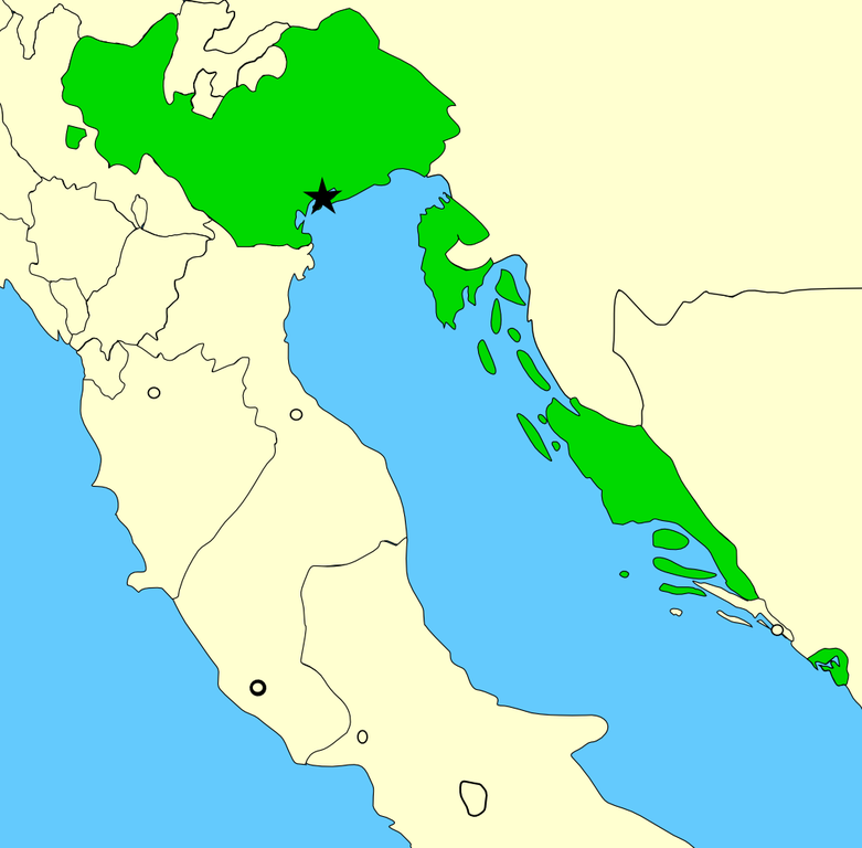
A map showing the territories of the Republic of Venice in the year 1796, before the Napoleonic invasions of that year. Please note that the Venetian-held Ionian Islands are not shown on this map; for a map of these possessions, see Image:Europe 1740.jpg. Created by MapMaster using Image:Italy 1796.png as base. |
| Data | 22 de novembre de 2006 (original upload date) |
| Font | No machine-readable source provided. Own work assumed (based on copyright claims). |
| Autor | No machine-readable author provided. MapMaster assumed (based on copyright claims). |
Llicència[modifica]
Jo, el titular dels drets d'autor d'aquest treball, el public sota la següent llicència:

|
S'autoritza la còpia, la distribució i la modificació d'aquest document sota els termes de la llicència de documentació lliure GNU versió 1.2 o qualsevol altra versió posterior que publiqui la Free Software Foundation; sense seccions invariants, ni textos de portada, ni textos de contraportada. S'inclou una còpia d'aquesta llicència en la secció titulada GNU Free Documentation License. |
| Aquest fitxer està subjecte a la llicència de Creative Commons Reconeixement i Compartir Igual 3.0 No adaptada. | ||
| ||
| Aquest avís de llicència s'ha afegit a aquest fitxer d'acord amb l'actualització de la llicència GFDL. |
Historial del fitxer
Cliqueu una data/hora per veure el fitxer tal com era aleshores.
| Data/hora | Miniatura | Dimensions | Usuari/a | Comentari | |
|---|---|---|---|---|---|
| actual | 00:18, 30 juny 2014 | | 1.026 × 1.009 (115 Ko) | Ras67 (discussió | contribucions) | cropped |
| 15:20, 24 feb 2008 |  | 1.040 × 1.023 (141 Ko) | MapMaster (discussió | contribucions) | Added small territory | |
| 03:56, 24 nov 2006 |  | 765 × 785 (88 Ko) | MapMaster (discussió | contribucions) | Now including the Bocche di Cattaro (Bay of Kotor), as suggested by 213 | |
| 05:43, 22 nov 2006 |  | 736 × 763 (90 Ko) | MapMaster (discussió | contribucions) | A map showing the territories of the Republic of Venice in the year 1796, before the Napoleonic invasions of that year. |
No podeu sobreescriure aquest fitxer.
Ús del fitxer
Les 5 pàgines següents utilitzen aquest fitxer:
Ús global del fitxer
Utilització d'aquest fitxer en altres wikis:
- Utilització a an.wikipedia.org
- Utilització a ar.wikipedia.org
- Utilització a az.wikipedia.org
- Utilització a be-tarask.wikipedia.org
- Utilització a be.wikipedia.org
- Utilització a bg.wikipedia.org
- Utilització a br.wikipedia.org
- Utilització a ca.wikipedia.org
- Utilització a da.wikipedia.org
- Utilització a de.wikipedia.org
- Utilització a en.wikipedia.org
- Utilització a eo.wikipedia.org
- Utilització a et.wikipedia.org
- Utilització a eu.wikipedia.org
- Utilització a fo.wikipedia.org
- Utilització a fr.wikipedia.org
- Utilització a fy.wikipedia.org
- Utilització a gl.wikipedia.org
- Utilització a hr.wikipedia.org
- Utilització a hu.wikipedia.org
- Utilització a id.wikipedia.org
- Utilització a incubator.wikimedia.org
- Utilització a it.wikipedia.org
- Utilització a ja.wikipedia.org
- Utilització a lmo.wikipedia.org
- Utilització a lt.wikipedia.org
- Utilització a lv.wikipedia.org
- Utilització a mk.wikipedia.org
- Utilització a nds.wikipedia.org
- Utilització a nl.wikipedia.org
Vegeu més usos globals d'aquest fitxer.