File:Rheinbund 1812, political map.png
跳至導覽
跳至搜尋

預覽大小:525 × 600 像素。 其他解析度:210 × 240 像素 | 420 × 480 像素 | 672 × 768 像素 | 896 × 1,024 像素 | 2,067 × 2,362 像素。
原始檔案 (2,067 × 2,362 像素,檔案大小:1.09 MB,MIME 類型:image/png)
說明
說明
添加單行說明來描述出檔案所代表的內容
摘要[編輯]
| 描述 |
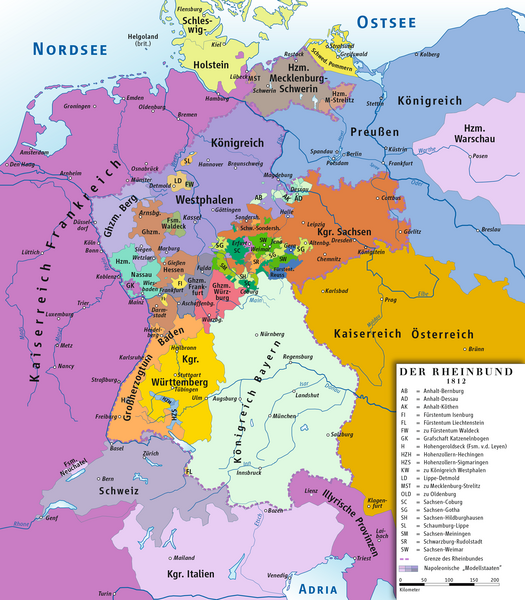
Deutsch: Karte des Rheinbundes 1812
English: Map of Confederation of the Rhine 1812 |
||||||||
| 日期 | |||||||||
| 來源 | 自己的作品 drawing/Source of Information: Putzger – Historischer Weltatlas, 89. Auflage, 1965; Westermanns Großer Atlas zuur Weltgeschichte, 1969; Haacks geographischer Atlas. VEB Hermann Haack Geographisch-Kartographische Anstalt, Gotha/Leipzig, 1. Auflage, 1979. | ||||||||
| 作者 | ziegelbrenner | ||||||||
| 授權許可 (重用此檔案) |
我,本作品的著作權持有者,決定用以下授權條款發佈本作品:
此檔案採用創用CC 姓名標示 2.5 通用版授權條款。
您可以選擇您需要的授權條款。 |


|
本圖片是以PNG、GIF或JPEG格式上傳。然而,其中包含的資料或訊息,應該重新建立成可縮放向量圖形(SVG)檔案,以更有效率或更準確的方式儲存。如有可能,請上傳本圖片的SVG格式版本。在上傳之後,請修改維基各姊妹計畫中所有使用舊版圖片的條目(列在圖像連結章節中),替換為新版圖片,並在舊圖片的描述頁中加入{{Vector version available|新圖片名稱.svg}}模板,同時移除本模板。
|
檔案歷史
點選日期/時間以檢視該時間的檔案版本。
| 日期/時間 | 縮圖 | 尺寸 | 使用者 | 備註 | |
|---|---|---|---|---|---|
| 目前 | 2014年2月14日 (五) 11:49 | | 2,067 × 2,362(1.09 MB) | Ziegelbrenner(留言 | 貢獻) | 2014-02-14 |
| 2014年2月3日 (一) 10:33 |  | 2,068 × 2,362(1.89 MB) | Ziegelbrenner(留言 | 貢獻) | 2014-02-03 | |
| 2014年1月31日 (五) 13:28 |  | 525 × 600(182 KB) | Ziegelbrenner(留言 | 貢獻) | Reverted to version as of 14:58, 21 January 2014 Why did you revert this? New version has some corrections. | |
| 2014年1月30日 (四) 16:14 |  | 2,008 × 2,362(1.72 MB) | Эрманарих(留言 | 貢獻) | Reverted to version as of 15:13, 3 February 2011 | |
| 2014年1月21日 (二) 14:58 |  | 525 × 600(182 KB) | Ziegelbrenner(留言 | 貢獻) | Some borders corrected | |
| 2011年2月3日 (四) 15:13 |  | 2,008 × 2,362(1.72 MB) | Ziegelbrenner(留言 | 貢獻) | 2011-02-03 | |
| 2011年2月3日 (四) 15:08 |  | 2,008 × 2,362(1.72 MB) | Ziegelbrenner(留言 | 貢獻) | 2011-02-03 | |
| 2011年2月3日 (四) 14:56 |  | 2,067 × 2,362(1.76 MB) | Ziegelbrenner(留言 | 貢獻) | 2011-02-03 | |
| 2011年2月3日 (四) 10:43 |  | 2,008 × 2,362(3.49 MB) | Ziegelbrenner(留言 | 貢獻) | 2011-02-03 | |
| 2010年5月30日 (日) 18:04 |  | 2,067 × 2,362(2.44 MB) | Max96(留言 | 貢獻) | Edited out the purple "blob" in Thuringia |
無法覆蓋此檔案。
檔案用途
下列3個頁面有用到此檔案:
全域檔案使用狀況
以下其他 wiki 使用了這個檔案:
- an.wikipedia.org 的使用狀況
- ar.wikipedia.org 的使用狀況
- ast.wikipedia.org 的使用狀況
- azb.wikipedia.org 的使用狀況
- be.wikipedia.org 的使用狀況
- br.wikipedia.org 的使用狀況
- ca.wikipedia.org 的使用狀況
- Liechtenstein
- Waldeck
- Confederació del Rin
- Ducat de Nassau
- Plantilla:Estats de la Confederació del Rin
- Gran Ducat de Berg
- Comtat d'Arenberg
- Hohenzollern-Sigmaringen
- Regne de Saxònia
- Regne de Westfàlia
- Regne de Baviera
- Gran ducat de Hessen i del Rin
- Regne de Württemberg
- Gran Ducat de Baden
- Anhalt
- Anhalt-Bernburg
- Anhalt-Dessau
- Anhalt-Köthen
- Saxònia-Weimar-Eisenach
- Saxònia-Eisenach
- Reuss-Ebersdorf
- Reuss-Lobenstein
- Schaumburg-Lippe
- Principat de Lippe
- Ducat de Mecklenburg-Schwerin
- cs.wikipedia.org 的使用狀況
- cv.wikipedia.org 的使用狀況
- da.wikipedia.org 的使用狀況
檢視此檔案的更多全域使用狀況。