File:Richat Structure ISS030-E-12516.jpg

原始文件 (4,288 × 2,848像素,文件大小:2.78 MB,MIME类型:image/jpeg)
说明
说明
摘要
[编辑]
| 描述 |
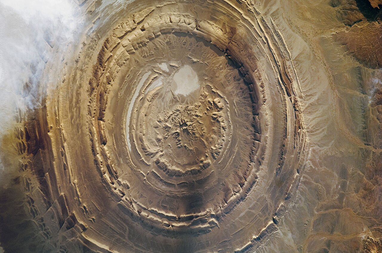
English: The Richat Structure of Mauritania has captured the attention of astronauts for about as long as NASA has sent humans into orbit around Earth. This circular geologic feature is thought to be caused by an uplifted dome—geologists would classify it as a domed anticline—that has been eroded to expose the originally flat rock layers.
In this type of geologic structure, rocks exposed in the center of the “bullseye” are older than rocks forming the outer rings. This structure measures 45 kilometers (28 miles) across and is made up of igneous and sedimentary rocks. There are several faults visible (lower left) where strata that were once continuous have been shifted apart. Most of Mauritania lies within the Sahara Desert, where dry climate conditions and periodic droughts create difficult living conditions. Approximately 3.7 million people live in Mauritania, though much of the population lives along its Atlantic coastline, about 500 kilometers (300 miles) from the Richat Structure. Astronaut photograph ISS030-E-12516 was acquired on December 17, 2011, with a Nikon D2Xs digital camera using a 400 millimeter lens and is provided by the ISS Crew Earth Observations Facility and the Earth Science and Remote Sensing Unit, Johnson Space Center. The image was taken by a member of the Expedition 30 crew. The image has been cropped and enhanced to improve contrast, and lens artifacts have been removed. The International Space Station Program supports the laboratory as part of the ISS National Lab to help astronauts take pictures of Earth that will be of the greatest value to scientists and the public, and to make those images freely available on the Internet. Additional images taken by astronauts and cosmonauts can be viewed at the NASA/JSC Gateway to Astronaut Photography of Earth. Caption by Andrea Meado, Jacobs Technology, JETS Contract at NASA-JSC. |
| 日期 | 摄于2011年12月17日, 17:28:02 |
| 来源 | https://earthobservatory.nasa.gov/images/92071/richat-structure; see also https://eol.jsc.nasa.gov/SearchPhotos/photo.pl?mission=ISS030&roll=E&frame=12516 |
| 作者 | NASA |
| Geographic Area | Mauritania |
| Features | RICHAT STRUCTURE, SAHARA DESERT |
| Clouds Percentage | 10% |
| Look angle | HO |
| Look direction | NE |
| Sun Azimuth | 240° |
| Sun Elevatation | 14° |
| Altitude | 219 nautical miles (406 km) |
| Mission | ISS030 |
| Roll | E |
| Frame | 12516 |
| Camera | Nikon D2Xs Electronic Still Camera |
| Focal length | 400 mm |
| 物体位置 | | 在以下服务上查看本图像和附近其他图像: OpenStreetMap |
|---|
本图像或视频收录于美国国家航空航天局 (NASA)休斯顿太空中心(Johnson Space Center),其照片编号是: ISS030-E-12516 以及Alternate ID: ISS030E12516 此标签不表示文件的著作权状态。任何文件在附有此标签的同時还需要一个有效的著作权标签。请参阅许可协议说明页面以了解更多信息。 其他语言:
|
许可协议
[编辑]
| 本文件完全由NASA创作,在美国属于公有领域。根据NASA的版权方针,NASA的材料除非另有声明否则不受版权保护。(参见Template:PD-USGov/zh、NASA版权方针页面或JPL图片使用方针。) | ||
 |
警告:
|
文件历史
点击某个日期/时间查看对应时刻的文件。
| 日期/时间 | 缩略图 | 大小 | 用户 | 备注 | |
|---|---|---|---|---|---|
| 当前 | 2021年2月25日 (四) 16:55 | | 4,288 × 2,848(2.78 MB) | Jstuby(留言 | 贡献) | Uploaded a work by NASA from NASA Earth Observatory, [https://earthobservatory.nasa.gov/images/92071/richat-structure Richat Structure] with UploadWizard |
您不可以覆盖此文件。
文件用途
以下页面使用本文件:
全域文件用途
以下其他wiki使用此文件:
- cs.wikipedia.org上的用途
- en.wikipedia.org上的用途
- zh.wikipedia.org上的用途