File:Rick 2021-10-24 2020Z.jpg
Jump to navigation
Jump to search

Size of this preview: 450 × 600 pixels. Other resolutions: 180 × 240 pixels | 360 × 480 pixels | 576 × 768 pixels | 768 × 1,024 pixels | 1,500 × 2,000 pixels.
Original file (1,500 × 2,000 pixels, file size: 751 KB, MIME type: image/jpeg)
Captions
Captions
Add a one-line explanation of what this file represents
Summary[edit]
| Description |
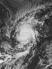
English: Hurricane Rick at peak intensity on October 24, 2021 (Grayscale). |
| Date | |
| Source | https://worldview.earthdata.nasa.gov/ |
| Author | NASA (Website) NOAA (Satellite) |
| Camera location | | View this and other nearby images on: OpenStreetMap |
|---|
Licensing[edit]
| This file is in the public domain in the United States because it was solely created by NASA. NASA copyright policy states that "NASA material is not protected by copyright unless noted". (See Template:PD-USGov, NASA copyright policy page or JPL Image Use Policy.) | ||
 |
Warnings:
|
This image is in the public domain because it contains materials that originally came from the U.S. National Oceanic and Atmospheric Administration, taken or made as part of an employee's official duties.
|
File history
Click on a date/time to view the file as it appeared at that time.
| Date/Time | Thumbnail | Dimensions | User | Comment | |
|---|---|---|---|---|---|
| current | 19:24, 21 November 2021 | | 1,500 × 2,000 (751 KB) | TheWxResearcher (talk | contribs) | m |
| 19:22, 21 November 2021 |  | 1,504 × 2,002 (445 KB) | TheWxResearcher (talk | contribs) | Uploaded a work by NASA (Website) NOAA (Satellite) from https://worldview.earthdata.nasa.gov/ with UploadWizard |
You cannot overwrite this file.
File usage on Commons
There are no pages that use this file.