File:Rietberg - NSG Rietberger Emsniederung und Fischteiche - Map.svg
Jump to navigation
Jump to search

Size of this PNG preview of this SVG file: 792 × 487 pixels. Other resolutions: 320 × 197 pixels | 640 × 394 pixels | 1,024 × 630 pixels | 1,280 × 787 pixels | 2,560 × 1,574 pixels.
Original file (SVG file, nominally 792 × 487 pixels, file size: 712 KB)
Captions
Captions
Add a one-line explanation of what this file represents
| Description |
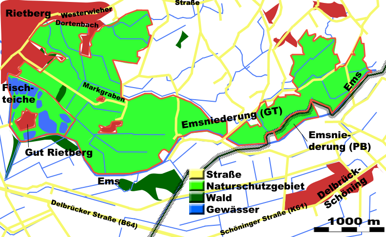
English: Rietberg - Nature reserves Rietberger Emsniederung and Rietberger Fischteiche - overview map
Deutsch: Rietberg - Naturschutzgebiete Rietberger Emsniederung und Rietberger Fischteiche - Übersichtskarte
Français : Rietberg - Réserves naturelles Rietberger Emsniederung et Rietberger Fischteiche - vue d'ensemble |
| Date | |
| Source | Own work |
| Author | Hagar66 |
| Permission (Reusing this file) |
Licensed under the GFDL by author |
| Camera location | | View this and other nearby images on: OpenStreetMap |
|---|
Homemade maps cannot be 100% accurate. This is especially true for topographical data that is hard to incorporate 100% correctly in such maps. You are free to use the map as a starting point for your new improved versions.
Licensing[edit]
I, the copyright holder of this work, hereby publish it under the following licenses:

|
Permission is granted to copy, distribute and/or modify this document under the terms of the GNU Free Documentation License, Version 1.2 or any later version published by the Free Software Foundation; with no Invariant Sections, no Front-Cover Texts, and no Back-Cover Texts. A copy of the license is included in the section entitled GNU Free Documentation License. |
This file is licensed under the Creative Commons Attribution-Share Alike 3.0 Unported, 2.5 Generic, 2.0 Generic and 1.0 Generic license.
- You are free:
- to share – to copy, distribute and transmit the work
- to remix – to adapt the work
- Under the following conditions:
- attribution – You must give appropriate credit, provide a link to the license, and indicate if changes were made. You may do so in any reasonable manner, but not in any way that suggests the licensor endorses you or your use.
- share alike – If you remix, transform, or build upon the material, you must distribute your contributions under the same or compatible license as the original.
You may select the license of your choice.
File history
Click on a date/time to view the file as it appeared at that time.
| Date/Time | Thumbnail | Dimensions | User | Comment | |
|---|---|---|---|---|---|
| current | 09:40, 4 February 2009 | | 792 × 487 (712 KB) | Hagar66 (talk | contribs) | {{Information |Description= {{en|''Rietberg - Nature reserves Rietberger Emsniederung and Rietberger Fischteiche - overview map''}} {{de|''Rietberg - Natursch |
You cannot overwrite this file.
File usage on Commons
The following 2 pages use this file: