File:Rif Damashq.svg
跳至導覽
跳至搜尋

此 SVG 檔案的 PNG 預覽的大小:800 × 523 像素。 其他解析度:320 × 209 像素 | 640 × 418 像素 | 1,024 × 670 像素 | 1,280 × 837 像素 | 2,560 × 1,674 像素 | 1,485 × 971 像素。
原始檔案 (SVG 檔案,表面大小:1,485 × 971 像素,檔案大小:7.38 MB)
說明
說明
添加單行說明來描述出檔案所代表的內容

摘要
[編輯]| 描述 |
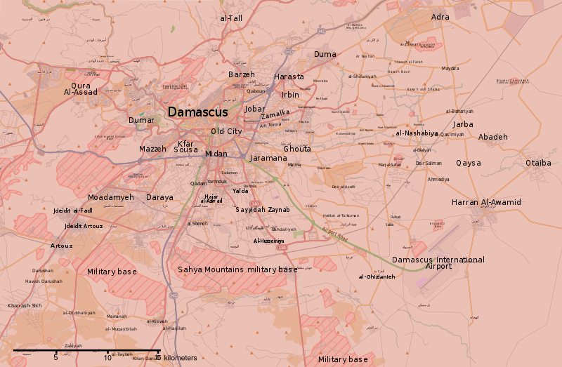
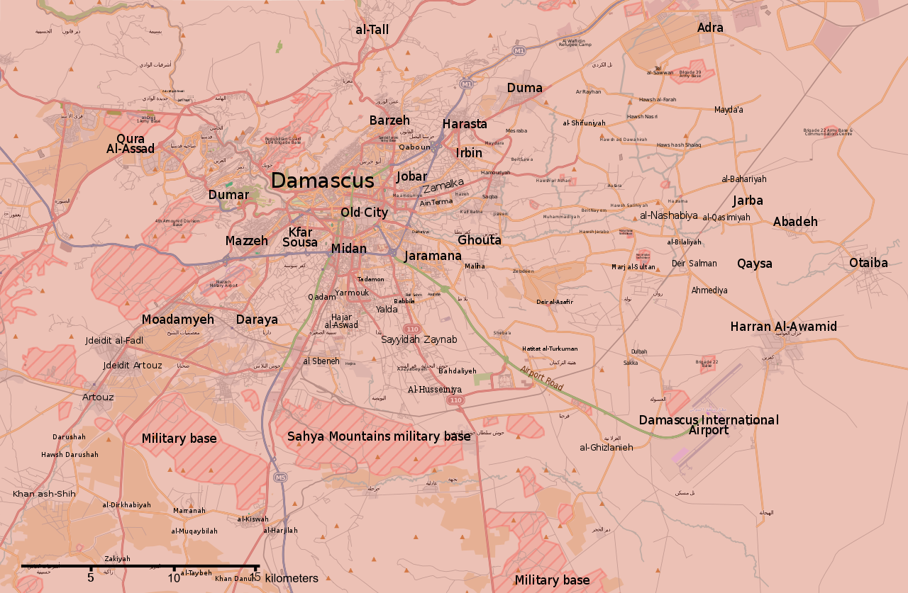
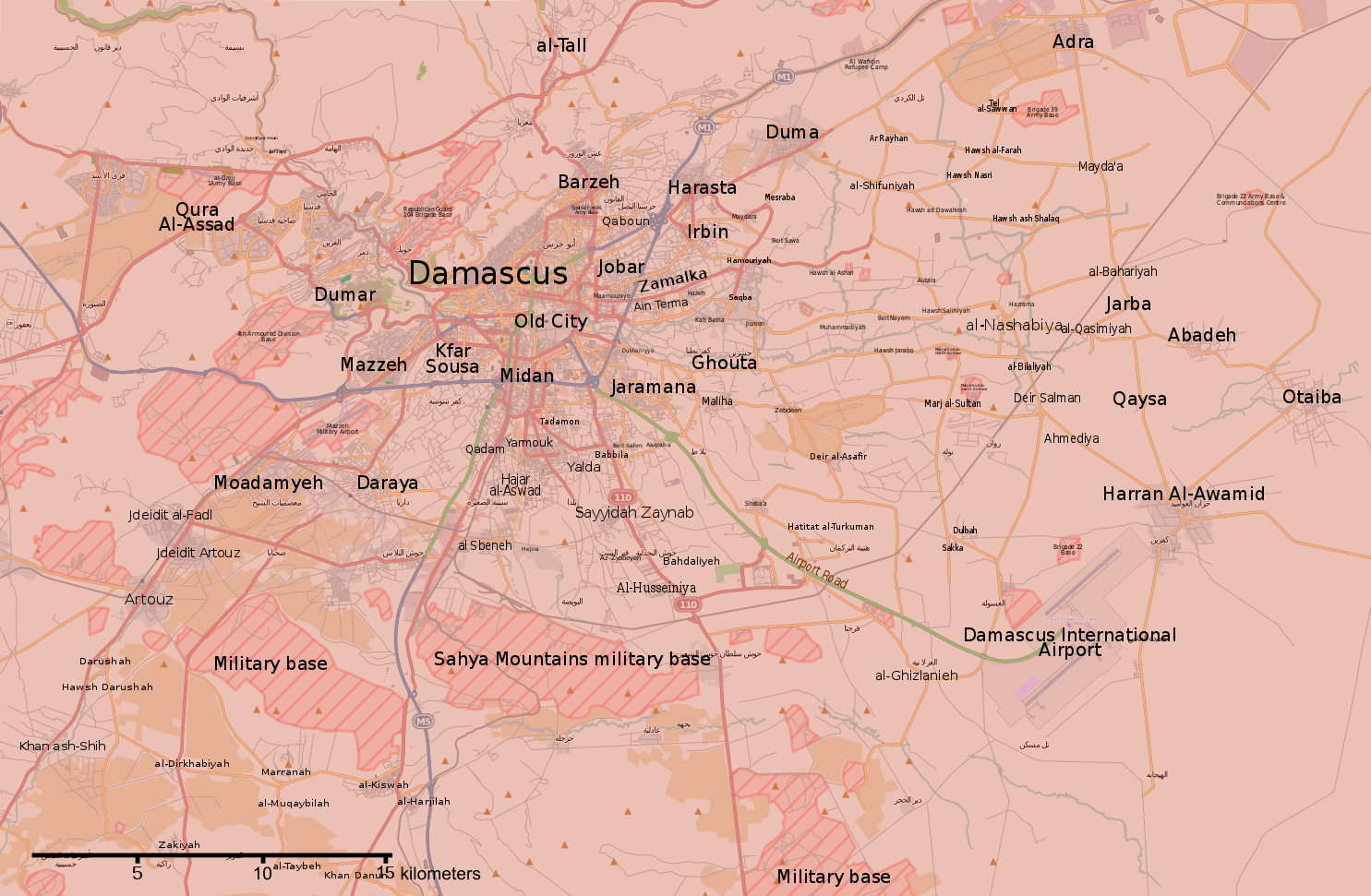
English: Map of the situation in Damascus and Rif Damashq during the Syrian Civil War.
English: Controlled by the Syrian Government
Controlled by the Syrian opposition
Controlled by the Islamic State of Iraq and the Levant
Truce/ceasefire zones
Contested/unclear situation العربية: خريطة الوضع في دمشق وريف دمشق خلال الحرب الأهلية السورية
تسيطر عليها الحكومة السورية
تسيطر عليها المعارضة السورية
تسيطر عليها تنظيم الدولة الإسلامية
مناطق الهدنة/وقف إطلاق النار
الحالة المتنازع عليها/غير الواضحة |
||||
| 日期 | |||||
| 來源 | File:Rif Dimashq offensive (September 2013).svg | ||||
| 作者 | MrPenguin20 | ||||
| 其他版本 |
Note: Comments "areas of activity" means that this is not territorial control is shown.
|
||||
| SVG開發 |


.svg)


.svg)


.svg)


_Territory_Change_2014-2016.gif)

_(within_Northern_Syria).svg)


.png)
.svg)


_map.png)
.svg)


.svg)


.svg)
授權條款
[編輯]
| This work contains information from OpenStreetMap, which is made available under the Open Database License (ODbL).
The ODbL does not require any particular license for maps produced from ODbL data. Prior to 1 August 2020, map tiles produced by the OpenStreetMap Foundation were licensed under the CC-BY-SA-2.0 license. Maps produced by other people may be subject to other licences. |
此檔案採用共享創意 姓名標示-相同方式分享 3.0 未在地化版本授權條款。
- 您可以自由:
- 分享 – 複製、發佈和傳播本作品
- 重新修改 – 創作演繹作品
- 惟需遵照下列條件:
- 姓名標示 – 您必須指名出正確的製作者,和提供授權條款的連結,以及表示是否有對內容上做出變更。您可以用任何合理的方式來行動,但不得以任何方式表明授權條款是對您許可或是由您所使用。
- 相同方式分享 – 如果您利用本素材進行再混合、轉換或創作,您必須基於如同原先的相同或兼容的條款,來分布您的貢獻成品。
檔案歷史
點選日期/時間以檢視該時間的檔案版本。
| 日期/時間 | 縮圖 | 尺寸 | 用戶 | 備註 | |
|---|---|---|---|---|---|
| 目前 | 2018年5月22日 (二) 02:15 | | 1,485 × 971(7.38 MB) | Kami888(對話 | 貢獻) | damascus cleared |
| 2018年5月8日 (二) 05:56 |  | 1,485 × 971(7.38 MB) | Kami888(對話 | 貢獻) | updates | |
| 2018年5月4日 (五) 18:00 |  | 1,485 × 971(7.38 MB) | Kami888(對話 | 貢獻) | Evacuation of HTS and other non-ISIS rebels, ISIS pocket reported to be split in two. | |
| 2018年4月29日 (日) 18:41 |  | 1,485 × 971(7.39 MB) | Kami888(對話 | 貢獻) | ISIS withdrew from Qadam http://www.syriahr.com/en/?p=90681 | |
| 2018年4月26日 (四) 13:34 |  | 1,485 × 971(7.39 MB) | Kami888(對話 | 貢獻) | Taking update from https://pbs.twimg.com/media/Dbp4AVbX0AAxqSe.jpg:large as the only source that I know of that reports on situation in south damascus | |
| 2018年4月14日 (六) 02:42 |  | 1,485 × 971(7.39 MB) | Kami888(對話 | 貢獻) | Army of Islam evacuated from Douma | |
| 2018年4月1日 (日) 23:19 |  | 1,485 × 971(7.45 MB) | Kami888(對話 | 貢獻) | FAR and HTS evacuated to Idlib http://www.syriahr.com/2018/03/31/%d8%a8%d8%a7%d8%b3%d8%aa%d8%ab%d9%86%d8%a7%d8%a1-%d8%af%d9%88%d9%85%d8%a7-%d9%82%d9%88%d8%a7%d8%aa-%d8%a7%d9%84%d9%86%d8%b8%d8%a7%d9%85-%d8%aa%d9%81%d8%b1%d8%b6-%d8%b3%d9%8a%d8%b7%d8%b1%d8%aa/ | |
| 2018年3月27日 (二) 03:16 |  | 1,485 × 971(7.71 MB) | Kami888(對話 | 貢獻) | Changed Harasta to red per suggestion on talk page. Other towns still evacuating. | |
| 2018年3月25日 (日) 10:43 |  | 1,485 × 971(7.76 MB) | Kami888(對話 | 貢獻) | Changed Ein Terma/Hazeh. Evacuation from the other towns still appears to be ongoing. | |
| 2018年3月20日 (二) 12:00 |  | 1,485 × 971(7.77 MB) | Kami888(對話 | 貢獻) | south Qadam to contested |
無法覆蓋此檔案。
檔案用途
超過 100 個頁面有用到此檔案。 下列清單只列出前 100 筆有用到此檔案的頁面。 您也可以檢視完整清單。
- User:Geagea/Israel/2015 December 15
- User:Geagea/Israel/2015 December 23
- User:Geagea/Israel/2015 December 7
- User:Geagea/Israel/2015 November 15
- User:Geagea/Israel/2015 November 5
- User:Geagea/Israel/2015 November 6
- User:Hermes79
- User:Hermes7979
- User:Magog the Ogre/Maps of conflicts/2016 August
- User:Magog the Ogre/Maps of conflicts/2016 December
- User:Magog the Ogre/Maps of conflicts/2016 July
- User:Magog the Ogre/Maps of conflicts/2016 May
- User:Magog the Ogre/Maps of conflicts/2016 October
- User:Magog the Ogre/Maps of conflicts/2016 September
- User:Magog the Ogre/Maps of conflicts/2017 January
- User:Magog the Ogre/Maps of conflicts/2017 June
- User:Magog the Ogre/Maps of conflicts/2017 March
- User:Magog the Ogre/Maps of conflicts/2017 May
- User:Magog the Ogre/Maps of conflicts/2017 November
- File:2013 Hama Offensive.svg
- File:2015 Latakia Frontlines.svg
- File:Aleppo Offensives 2015.svg
- File:Aleppo offensive (October 2013).svg
- File:Attaques-terroristes-meurtrières-au-21eme-siecle.png
- File:Battle of Daraa City.svg
- File:Battle of Hasakah.svg
- File:Battle of Qamishli.svg
- File:Battle of Raqqa.svg
- File:Battle of Tadmur.svg
- File:Battle of Western Qalamoun.svg
- File:Battlefields in The Global War on Terror.svg
- File:Battlefields in The Global War on Terror - edit03.png
- File:Battlefields in The Global War on Terror - edit04.png
- File:Benghazi Conflict Detailed Map.png
- File:Benghazi Conflict Detailed Map.svg
- File:Boko Haram insurgency map.svg
- File:Countries by soldier count.svg
- File:Deir ez-Zor clashes (2017).svg
- File:Derna Conflict Detailed Map.png
- File:East Congo conflict map.svg
- File:GSPC map.png
- File:ISIS (Grey) Territory Change 2014-2016.gif
- File:Iraqi Civil War map (2014–present).png
- File:Iraqi–Kurdish conflict map.png
- File:Islamist insurgency in Nigeria.svg
- File:Lebanese insurgency.svg
- File:Libyan Civil War.svg
- File:Libyan war final-fr.svg
- File:Map of Ongoing conflicts around the world.png
- File:Map of terror of the Islamic State (ad-Daula al-islāmiyya).png
- File:Mexico states map small war.PNG
- File:Mosul offensive (2015) map.png
- File:Number of Terrorist Incidents.png
- File:Ongoing Conflicts (1).png
- File:Pakistan-Waziristan-Map.png
- File:Political map Afar triangle.png
- File:Rif Damashq.svg
- File:Siege of Homs Map.svg
- File:Sinai insurgency.svg
- File:Somali Civil War (2009-present).svg
- File:Syria and Iraq 2014-onward War map.png
- File:Syrian, Iraqi, and Lebanese insurgencies.png
- File:Syrian Civil War map.svg
- File:Syrian civil war.png
- File:Tadmur offensive (2015).jpg
- File:Yemeni Civil War.svg
- Template:City maps of ongoing civil wars
- Category:Aleppo
- Category:Attack
- Category:Battle of Aleppo
- Category:Battles in 2016
- Category:Battles of Syria
- Category:Battles of the Syrian Civil War
- Category:Cities in Syria
- Category:Civil wars
- Category:Conflicts
- Category:Conflicts by continent
- Category:Conflicts by country
- Category:Conflicts by type
- Category:Feuds
- Category:Fights
- Category:Liberation of Palmyra (2016)
- Category:Maps of Aleppo
- Category:Maps of Somali Civil War
- Category:Maps of conflicts
- Category:Maps of disputed territories
- Category:Maps of the Syrian Civil War in 2016
- Category:Maps of the Syrian Civil War in 2017
- Category:Military conflicts
- Category:Ongoing armed conflicts
- Category:Palmyra offensive (December 2016)
- Category:Quarrels
- Category:Rebellions
- Category:Riots
- Category:Schisms
- Category:Syrian Civil War
- Category:Terrorism
- Category:Uprisings
- Category:War casualties
- Category:Warfare by type
.svg)
.png)
.png)
.png)
.jpg)
檢視連結到這個檔案的更多連結。
全域檔案使用狀況
以下其他 wiki 使用了這個檔案:
- ar.wikipedia.org 的使用狀況
- be.wikipedia.org 的使用狀況
- en.wikipedia.org 的使用狀況
- es.wikipedia.org 的使用狀況
- fa.wikipedia.org 的使用狀況
- fo.wikipedia.org 的使用狀況
- hu.wikipedia.org 的使用狀況
- hy.wikipedia.org 的使用狀況
- id.wikipedia.org 的使用狀況
- ko.wikipedia.org 的使用狀況
- ku.wikipedia.org 的使用狀況
- pa.wikipedia.org 的使用狀況
- pl.wikipedia.org 的使用狀況
- pt.wikipedia.org 的使用狀況
- ru.wikipedia.org 的使用狀況
- tr.wikipedia.org 的使用狀況
- www.wikidata.org 的使用狀況
- zh.wikipedia.org 的使用狀況