File:Rigobert Bonne, Carte de l'empire de la Chine, de la Tartarie (FL46961854 2467987).jpg
Jump to navigation
Jump to search

Size of this preview: 423 × 599 pixels. Other resolutions: 169 × 240 pixels | 339 × 480 pixels | 542 × 768 pixels | 722 × 1,024 pixels | 1,445 × 2,048 pixels | 5,855 × 8,297 pixels.
Original file (5,855 × 8,297 pixels, file size: 68.41 MB, MIME type: image/jpeg)
Captions
Captions
Add a one-line explanation of what this file represents
Summary
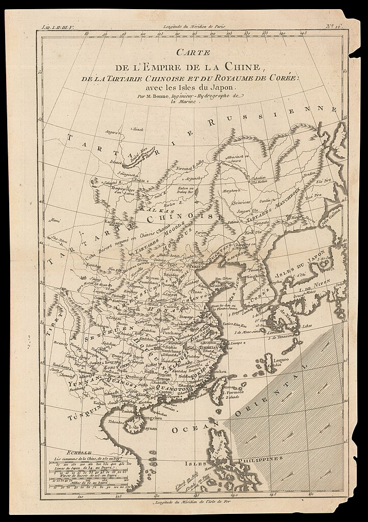
[edit]| Rigobert Bonne: Carte de l'empire de la Chine, de la Tartarie
( |
||||||||||||||||||||||||
|---|---|---|---|---|---|---|---|---|---|---|---|---|---|---|---|---|---|---|---|---|---|---|---|---|
| Artist |
|
|||||||||||||||||||||||
| Title |
Carte de l'empire de la Chine, de la Tartarie |
|||||||||||||||||||||||
| Publisher |
J. L. Pellet? |
|||||||||||||||||||||||
| Description |
Carte de l'empire de la Chine, de la Tartarie.... Par M.Bonne. |
|||||||||||||||||||||||
| Language | French | |||||||||||||||||||||||
| Publication date | 1780s possibly | |||||||||||||||||||||||
| Medium | 1 map ; | |||||||||||||||||||||||
| Dimensions | height: 315 mm (12.40 in); width: 208 mm (8.18 in) | |||||||||||||||||||||||
| Collection |
|
|||||||||||||||||||||||
| Current location |
|
|||||||||||||||||||||||
| Place of publication | Geneva | |||||||||||||||||||||||
| Notes | Probably from: Atlas de toutes les parties connues du globe terrestre, dressé pour l'histoire philosophique et politique... no. 16. | |||||||||||||||||||||||
| IE PID | IE46961852 | |||||||||||||||||||||||
| Rosetta filename | FL46961854 | |||||||||||||||||||||||
| NNL item ID (P3959) | 990024679870205171 | |||||||||||||||||||||||
| search Merhav catalog | French, Rigobert Bonne, Geneva | |||||||||||||||||||||||
| search Merhav catalog | J. L. Pellet? | |||||||||||||||||||||||
| Source/Photographer |
|
|||||||||||||||||||||||
| Other versions | ||||||||||||||||||||||||
| Jpg / Tif version |
|
|||||||||||||||||||||||

.jpg)

.jpg&action=edit§ion=1)
Licensing
[edit].jpg&action=edit§ion=2)
The copyright situation of this work is theoretically uncertain, because in the country of origin copyright lasts 70 years after the death of the author, and the date of the author's death is unknown. However, the date of creation of the work was over 120 years ago, and it is thus a reasonable assumption that the copyright has expired (see here for the community discussion). Do not use this template if the date of death of the author is known.
| |
| This file has been identified as being free of known restrictions under copyright law, including all related and neighboring rights. | |
File history
Click on a date/time to view the file as it appeared at that time.
| Date/Time | Thumbnail | Dimensions | User | Comment | |
|---|---|---|---|---|---|
| current | 22:22, 31 July 2023 | | 5,855 × 8,297 (68.41 MB) | Geagea (talk | contribs) | c:User:Rillke/bigChunkedUpload.js: =={{int:filedesc}}== {{Artwork |artist = {{Creator|wikidata=Q721492}} |author = |title = Carte de l'empire de la Chine, de la Tartarie |description = Carte de l'empire de la Chine, de la Tartarie.... Par M.Bonne. |language = {{Label|1=Q150}} |date = |publication date = {{other date|s|1780}} {{Label|1=Q30230067}} |medium = 1 map ; |dimensions = {{size|mm|315|208}} |institution = {{Institution:Eran Laor Cartographic Collection}} |department =... |
You cannot overwrite this file.
File usage on Commons
The following page uses this file:
.jpg&oldid=788817135)