File:Rio San Pablo.jpg
跳转到导航
跳转到搜索

本预览的尺寸:457 × 599像素。 其他分辨率:183 × 240像素 | 366 × 480像素 | 586 × 768像素 | 781 × 1,024像素 | 1,562 × 2,048像素 | 3,451 × 4,525像素。
原始文件 (3,451 × 4,525像素,文件大小:7.69 MB,MIME类型:image/jpeg)
说明
说明
添加一行文字以描述该文件所表现的内容
摘要
[编辑]
| 描述 |
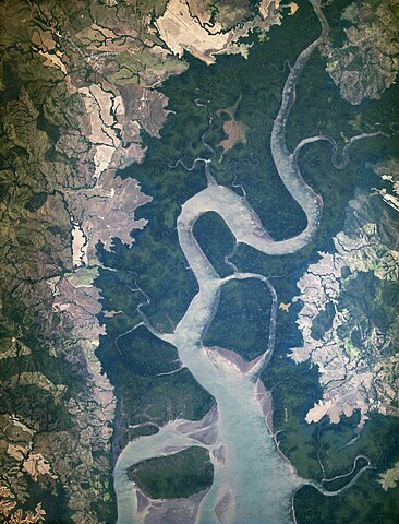
English: The image above is the “first light” from the new ISERV camera system, taken at 1:44 p.m. local time on February 16, 2013. It shows the Rio San Pablo as it empties into the Golfo de Montijo in Veraguas, Panama. It is an ecological transition zone, changing from agriculture and pastures to mangrove forests, swamps, and estuary systems. The area has been designated a protected area by the National Environmental Authority (ANAM) of Panama and is listed as a “wetland of international importance” under the Ramsar Convention. (Note that the image is rotated so that north is to the upper right.) |
| 日期 | |
| 来源 | https://flic.kr/p/e1EQPs |
| 作者 | NASA |
许可协议
[编辑]
| 这幅图片原始出处为Flickr的https://www.flickr.com/photos/24662369@N07/8540216464 ,作者为NASA Goddard Photo and Video 。经机器人FlickreviewR在2014年8月4日审查后确定为采用cc-by-2.0的协议授权使用。 |
| 本文件完全由NASA创作,在美国属于公有领域。根据NASA的版权方针,NASA的材料除非另有声明否则不受版权保护。(参见Template:PD-USGov/zh、NASA版权方针页面或JPL图片使用方针。) | ||
 |
警告:
|
文件历史
点击某个日期/时间查看对应时刻的文件。
| 日期/时间 | 缩略图 | 大小 | 用户 | 备注 | |
|---|---|---|---|---|---|
| 当前 | 2014年8月4日 (一) 19:09 | | 3,451 × 4,525(7.69 MB) | Numéro 1963(留言 | 贡献) | User created page with UploadWizard |
您不可以覆盖此文件。
文件用途
以下页面使用本文件:
.jpg&redirect=no)
全域文件用途
以下其他wiki使用此文件:
- ceb.wikipedia.org上的用途
- en.wikipedia.org上的用途
- es.wikipedia.org上的用途
- www.wikidata.org上的用途
- zh.wikipedia.org上的用途