File:Riviere aux Outardes carte.png
Jump to navigation
Jump to search
No higher resolution available.
Riviere_aux_Outardes_carte.png (334 × 222 pixels, file size: 17 KB, MIME type: image/png)
Captions
Captions
Add a one-line explanation of what this file represents
| Description |
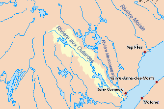
Français : Bassin versant de la Rivière aux Outardes (Québec, Canada). |
| Date | (UTC) |
| Source | |
| Author |
|
| This is a retouched picture, which means that it has been digitally altered from its original version. Modifications: Translated into French.. The original can be viewed here: Outardes map.png:
|
I, the copyright holder of this work, hereby publish it under the following license:
| I, the copyright holder of this work, release this work into the public domain. This applies worldwide. In some countries this may not be legally possible; if so: I grant anyone the right to use this work for any purpose, without any conditions, unless such conditions are required by law. |
Original upload log
[edit]
This image is a derivative work of the following images:
- File:Outardes_map.png licensed with PD-self
- 2010-10-29T21:13:55Z P199 334x222 (14573 Bytes) {{Information |Description={{en|1=Drainage basin of the Outardes River, Quebec, Canada.}} |Source=Own work based on info from [http://atlas.nrcan.gc.ca/site/english/maps/environment/hydrology/drainagebasins Atlas of Canada] |
Uploaded with derivativeFX
File history
Click on a date/time to view the file as it appeared at that time.
| Date/Time | Thumbnail | Dimensions | User | Comment | |
|---|---|---|---|---|---|
| current | 15:09, 17 January 2011 | | 334 × 222 (17 KB) | Piotron (talk | contribs) | {{Information |Description={{fr|1=Bassin versant de la Rivière aux Outardes (Québec, Canada).}} |Source=*File:Outardes_map.png |Date=2011-01-17 15:08 (UTC) |Author=*File:Outardes_map.png: P199 *derivative work: ~~~ |Permission= |
You cannot overwrite this file.
File usage on Commons
There are no pages that use this file.
File usage on other wikis
The following other wikis use this file:
- Usage on es.wikipedia.org