File:Rogue River Ranch Site Map.png
Jump to navigation
Jump to search

Size of this preview: 355 × 599 pixels. Other resolutions: 142 × 240 pixels | 284 × 480 pixels | 709 × 1,197 pixels.
Original file (709 × 1,197 pixels, file size: 19 KB, MIME type: image/png)
Captions
Captions
Add a one-line explanation of what this file represents
| Description |
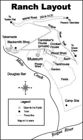
English: Site map of the Rogue River Ranch; the ranch is located on the north shore of the Rogue River at the mouth of Mule Creek in Curry County, Oregon |
||||||
| Date |
|
||||||
| Source | http://www.blm.gov/or/resources/recreation/rogue/files/RogueRiverRanch2004.pdf | ||||||
| Author | Bureau of Land Management, United States Department of Interior | ||||||
| Permission (Reusing this file) |
|
||||||

Original upload log
[edit]
The original description page was here. All following user names refer to en.wikipedia.
- 2009-03-14 03:07 Orygun 709×1197× (19914 bytes) {{Information |Description=Site map of the Rogue River Ranch; the ranch is located on the north shore of the Rogue River at the mouth of Mule Creek in Curry County, Oregon |Source=http://www.blm.gov/or/resources/recreation/rogue/files/RogueRiverRanch2004.
File history
Click on a date/time to view the file as it appeared at that time.
| Date/Time | Thumbnail | Dimensions | User | Comment | |
|---|---|---|---|---|---|
| current | 14:16, 24 March 2009 | | 709 × 1,197 (19 KB) | Matthiasb (talk | contribs) | {{Information |Description={{en|Site map of the Rogue River Ranch; the ranch is located on the north shore of the Rogue River at the mouth of Mule Creek in Curry County, Oregon}} |Source=Transferred from [http://en.wikipedia.org en.wikipedia]; transferred |
You cannot overwrite this file.
File usage on Commons
There are no pages that use this file.
File usage on other wikis
The following other wikis use this file:
- Usage on de.wikipedia.org
- Usage on en.wikipedia.org