File:Rojava february 2014.png
Here nagîvasyonê
Here lêgerînê

Mezinahiya vê pêşdîtinê: 800 × 369 pîksel. Resolusyonên din: 320 × 148 pîksel | 640 × 296 pîksel | 1124 × 519 pîksel.
Dosyeya orjînal (1124 × 519 pixel, mezinbûnê data: 42 KB, MIME-typ: image/png)
Captions
Captions
Add a one-line explanation of what this file represents
Danasîn[biguhêre]
| Danasîn |
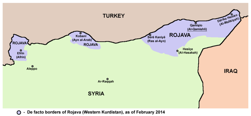
English: Map showing de facto borders of Rojava (Western Kurdistan) in February 2014. |
| Dîrok | |
| Çavkanî | Min çêkir |
| Xwedî | PANONIAN |
Lîsans[biguhêre]
I, the copyright holder of this work, hereby publish it under the following license:
| This file is made available under the Creative Commons CC0 1.0 Universal Public Domain Dedication. | |
| The person who associated a work with this deed has dedicated the work to the public domain by waiving all of their rights to the work worldwide under copyright law, including all related and neighboring rights, to the extent allowed by law. You can copy, modify, distribute and perform the work, even for commercial purposes, all without asking permission.
|
References[biguhêre]
Borders of Rojava (Western Kurdistan) in February 2014:
Dîroka daneyê
Ji bo dîtina guhartoya wê demê bişkoka dîrokê bitikîne.
| Dîrok/Katjimêr | Wêneyê biçûk | Mezinahî | Bikarhêner | Şirove | |
|---|---|---|---|---|---|
| niha | 08:29, 13 kanûna paşîn 2017 | | 1124 x 519 (42 KB) | PANONIAN (gotûbêj | beşdarî) | {{Information |Description ={{en|1=Map showing de facto borders of Rojava (Western Kurdistan) in February 2014.}} |Source =own work |Author =PANONIAN |Date =2017 |Permission = |other_versions = }} |
Tu nikarî cardin li ser vê dosyeyê binivîsînî.
Bikaranîna pelê
Ev rûpelên li jêr vê dosyeyê bi kar tînin:
Bikaranîna gerdûnî ya pelê
Ev wîkiyên di rêzê de vê pelê bi kar tînin:
- Bikaranîna di br.wikipedia.org de
- Bikaranîna di bs.wikipedia.org de
- Bikaranîna di ca.wikipedia.org de
- Bikaranîna di ckb.wikipedia.org de
- Bikaranîna di cs.wikipedia.org de
- Bikaranîna di da.wikipedia.org de
- Bikaranîna di de.wikipedia.org de
- Bikaranîna di el.wikipedia.org de
- Bikaranîna di en.wikipedia.org de
- Bikaranîna di eo.wikipedia.org de
- Bikaranîna di es.wikipedia.org de
- Bikaranîna di fa.wikipedia.org de
- Bikaranîna di fi.wikipedia.org de
- Bikaranîna di fr.wikipedia.org de
- Bikaranîna di he.wikipedia.org de
- Bikaranîna di hy.wikipedia.org de
- Bikaranîna di id.wikipedia.org de
- Bikaranîna di it.wikipedia.org de
- Bikaranîna di ja.wikipedia.org de
- Bikaranîna di ko.wikipedia.org de
- Bikaranîna di ku.wikipedia.org de
- Bikaranîna di lv.wikipedia.org de
- Bikaranîna di ml.wikipedia.org de
- Bikaranîna di mzn.wikipedia.org de
- Bikaranîna di nl.wikipedia.org de
- Bikaranîna di nn.wikipedia.org de
- Bikaranîna di no.wikipedia.org de
- Bikaranîna di pl.wiktionary.org de
- Bikaranîna di pnb.wikipedia.org de
- Bikaranîna di pt.wikipedia.org de
- Bikaranîna di ro.wikipedia.org de
- Bikaranîna di ru.wikipedia.org de
- Bikaranîna di sh.wikipedia.org de
- Bikaranîna di sk.wikipedia.org de
- Bikaranîna di sr.wikipedia.org de
- Bikaranîna di sv.wikipedia.org de
- Bikaranîna di tr.wikipedia.org de
- Bikaranîna di uk.wikipedia.org de
Zêdetir bikaranîna global a vê pelê bibîne.