File:Rolf 2011-11-08 1030Z.jpg
Jump to navigation
Jump to search

Size of this preview: 473 × 599 pixels. Other resolutions: 189 × 240 pixels | 379 × 480 pixels | 606 × 768 pixels | 808 × 1,024 pixels | 1,617 × 2,048 pixels | 6,000 × 7,600 pixels.
Original file (6,000 × 7,600 pixels, file size: 7.38 MB, MIME type: image/jpeg)
Captions
Captions
Add a one-line explanation of what this file represents
Summary[edit]
| Description |
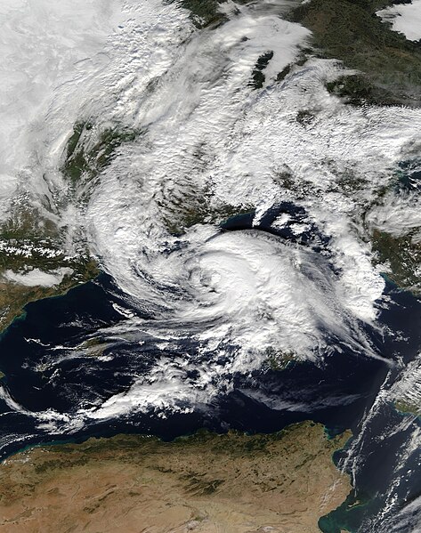
English: MODIS Terra image of Tropical Storm 01M, classified by NOAA SSD, named Rolf as a low-pressure area by the Free University of Berlin
Deutsch: Satellitenbild des MODIS-Terra-Instruments des tropensturmähnlichen Zyklons 01-M, klassifiziert durch NOAA SSD, benannt Rolf als Tiefdruckgebiet durch die Freie Universität Berlin |
| Date | |
| Source | http://lance-modis.eosdis.nasa.gov/imagery/subsets/?subset=Europe_3_02.2011312.terra.250m |
| Author | MODIS Rapid Response Team at NASA GSFC. |
Licensing[edit]
| This file is in the public domain in the United States because it was solely created by NASA. NASA copyright policy states that "NASA material is not protected by copyright unless noted". (See Template:PD-USGov, NASA copyright policy page or JPL Image Use Policy.) | ||
 |
Warnings:
|
File history
Click on a date/time to view the file as it appeared at that time.
| Date/Time | Thumbnail | Dimensions | User | Comment | |
|---|---|---|---|---|---|
| current | 19:09, 3 February 2021 | | 6,000 × 7,600 (7.38 MB) | FleurDeOdile (talk | contribs) | m |
| 20:02, 30 July 2013 |  | 6,880 × 6,020 (5.28 MB) | TheAustinMan (talk | contribs) | Centered on storm. | |
| 18:27, 8 November 2011 |  | 4,600 × 5,200 (5.81 MB) | Matthiasb (talk | contribs) | {{Information |Description ={{en|1=MODIS Terra image of tropical-like cyclone 01-M, classified by NOAA SSD, named Rolf as a low pressure area by the Free University of Berlin}} {{de|1=Satellitenbild des MODIS-Terra-Instruments des tropensturmähnlichen |
You cannot overwrite this file.
File usage on Commons
The following 3 pages use this file:
- File:Tropical-like cyclone 01-M Rolf.2011312.terra.250m.jpg (file redirect)
- File:Tropical-like cyclone Rolf 08-Nov-2011.jpg (file redirect)
- Category:Tropical Storm Rolf
File usage on other wikis
The following other wikis use this file:
- Usage on cs.wikipedia.org
- Usage on de.wikipedia.org
- Usage on el.wikipedia.org
- Usage on en.wikipedia.org
- User talk:AySz88
- User talk:WmE
- User talk:Titoxd
- User talk:Yellow Evan
- User talk:HurricaneSpin
- User talk:Dylan620
- User talk:Iune
- Mediterranean tropical-like cyclone
- User:Atomic7732/Mediterranean tropical cyclone
- Wikipedia talk:WikiProject Tropical cyclones/Archive 27
- User:LightandDark2000/My Notable Storms
- Tropical Storm Rolf
- User:Rosalina2427/Archive5
- User talk:CooperScience
- User talk:Floridaball
- User talk:LightandDark2000/Archive 4
- User talk:Hurricaneboy23
- User talk:Cyclonebiskit/Archive19
- User talk:The Grid/Archive 9
- User talk:Cyclone Toby
- User talk:Shift674
- User talk:KN2731/Archive 4
- User talk:CyclonicStormYutu
- User talk:HurricaneParrot
- User talk:Locomotive207/archive
- User talk:SovietCyclone
- User talk:HikingHurricane/Archive 1
- User talk:AwesomeHurricaneBoss
- Wikipedia:WikiProject Tropical cyclones/Newsletter/Archive 47
- User talk:Tc06cimaron
- User talk:Super Cyclonic Storm Corona/Archive/2021
- User talk:PurpleLights/Archive 1
- User talk:Stratacus1
- User talk:HeartGlow30797/Archives/2021/May
- User talk:Chicdat/Archive 6
- User talk:ChessEric/Archives/2021/May
- User talk:X!/Archives/05/2021
- User talk:Beraniladri19/Archive/2021/May
- User talk:CycloneFootball71/Archive 1
- User talk:Destroyeraa/Archive 4
- User talk:Hurricane Noah/Archive 5
- User talk:Giovaunni/Archive 2
- User talk:Akbermamps/Archive 2
- User talk:12george1/Archive 29
- User talk:Skarmory/Newsletters and mass messages 1
- User talk:Jo-Jo Eumerus/Archive 79
View more global usage of this file.