File:Roma Antiga - 500 a.C..svg
Jump to navigation
Jump to search

Size of this PNG preview of this SVG file: 512 × 441 pixels. Other resolutions: 279 × 240 pixels | 557 × 480 pixels | 892 × 768 pixels | 1,189 × 1,024 pixels | 2,378 × 2,048 pixels.
Original file (SVG file, nominally 512 × 441 pixels, file size: 26 KB)
Captions
Captions
Add a one-line explanation of what this file represents
Summary
[edit]| Description |
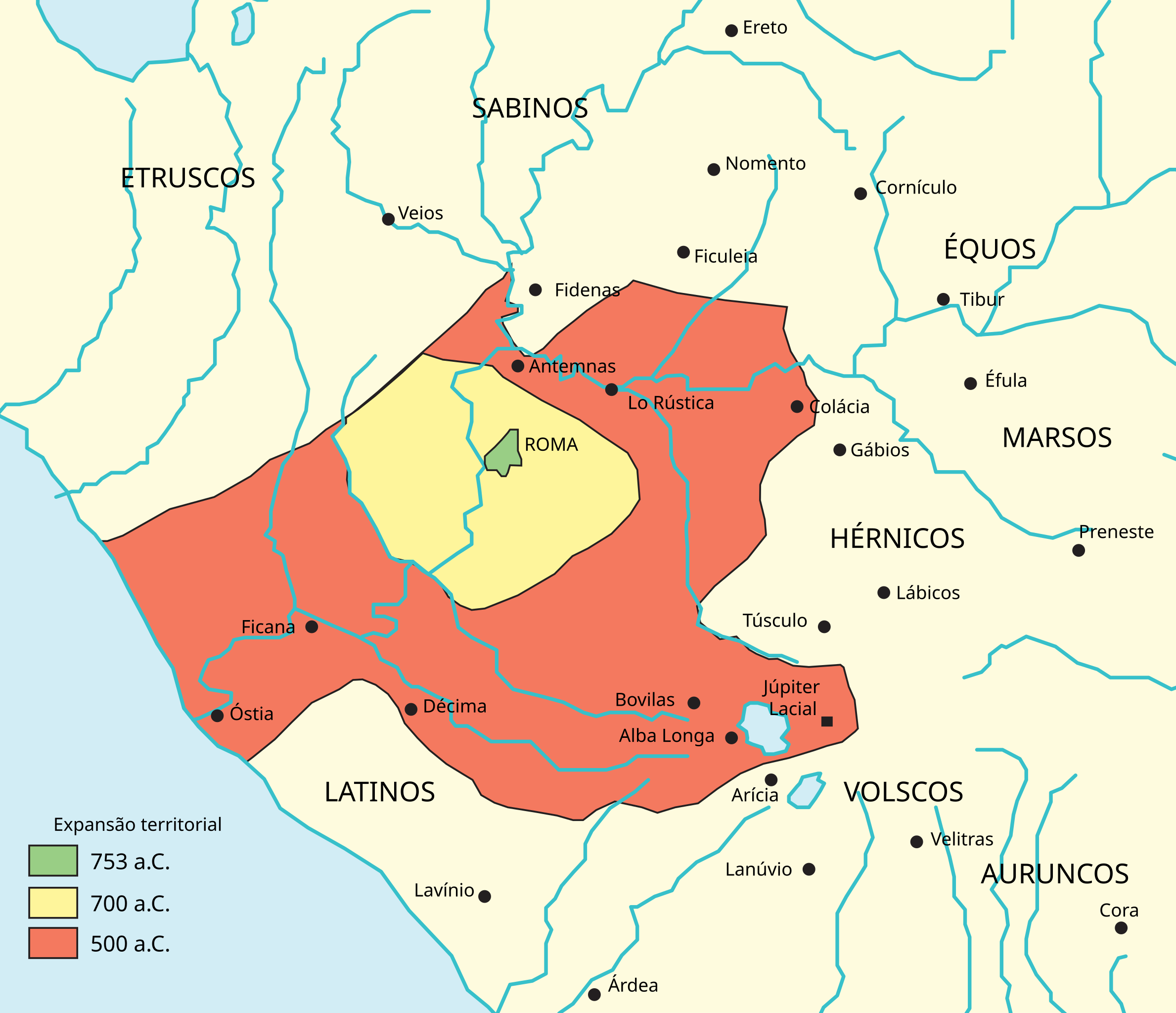
Português: Mapa do território romano em 500 a.C. Baseado no mapa presente na página 27 do livro Grande Civilizações do Passado - A civilização romana de Tim Cornell e John Matthews. |
| Date | |
| Source | Own work |
| Author | Renato de carvalho ferreira |
| Other versions |
|

Licensing
[edit]
I, the copyright holder of this work, hereby publish it under the following license:
| This file is made available under the Creative Commons CC0 1.0 Universal Public Domain Dedication. | |
| The person who associated a work with this deed has dedicated the work to the public domain by waiving all of their rights to the work worldwide under copyright law, including all related and neighboring rights, to the extent allowed by law. You can copy, modify, distribute and perform the work, even for commercial purposes, all without asking permission.
|
File history
Click on a date/time to view the file as it appeared at that time.
| Date/Time | Thumbnail | Dimensions | User | Comment | |
|---|---|---|---|---|---|
| current | 21:49, 30 September 2020 | | 512 × 441 (26 KB) | Ferdi2005 (talk | contribs) | File uploaded using svgtranslate tool (https://svgtranslate.toolforge.org/). Added translation for it. |
| 14:20, 30 September 2020 |  | 512 × 441 (26 KB) | Ferdi2005 (talk | contribs) | File uploaded using svgtranslate tool (https://svgtranslate.toolforge.org/). Added translation for it. | |
| 04:43, 27 October 2017 |  | 512 × 441 (18 KB) | Renato de Carvalho Ferreira (talk | contribs) | Reverted to version as of 01:31, 1 June 2016 (UTC) | |
| 04:41, 27 October 2017 |  | 512 × 441 (64 KB) | Renato de Carvalho Ferreira (talk | contribs) | Ajustando fundo | |
| 14:51, 24 October 2017 |  | 512 × 441 (64 KB) | Renato de Carvalho Ferreira (talk | contribs) | Ajustes gerais | |
| 01:31, 1 June 2016 |  | 512 × 441 (18 KB) | Renato de Carvalho Ferreira (talk | contribs) | Ajustes em alguns topônimos | |
| 05:15, 6 March 2014 |  | 644 × 554 (24 KB) | Renato de Carvalho Ferreira (talk | contribs) | Localização aproximada dos povos vizinhos. | |
| 05:09, 6 March 2014 |  | 644 × 554 (24 KB) | Renato de Carvalho Ferreira (talk | contribs) | Legenda | |
| 05:04, 6 March 2014 |  | 644 × 554 (23 KB) | Renato de Carvalho Ferreira (talk | contribs) | User created page with UploadWizard |
You cannot overwrite this file.
File usage on Commons
The following page uses this file:
File usage on other wikis
The following other wikis use this file:
- Usage on be.wikipedia.org
- Usage on bg.wikipedia.org
- Usage on en.wikipedia.org
- Usage on es.wikipedia.org
- Usage on it.wikipedia.org
- Usage on nl.wikipedia.org
- Usage on pt.wikipedia.org
- República Romana
- Lista de Estados extintos
- Reino de Roma
- Portal:Roma Antiga
- Wikipédia:Artigos destacados/arquivo/Reino de Roma
- Usuário:Renato de Carvalho Ferreira/mapas
- Portal:Roma Antiga/Artigo selecionado
- Portal:Roma Antiga/Artigo selecionado/1
- Portal:Arqueologia/Artigo em Destaque/Arquivo/Reino de Roma
- Usage on sv.wikipedia.org
- Usage on uk.wikipedia.org