File:Roma Plan bw.jpg

Fitxer original (1.840 × 1.463 píxels, mida del fitxer: 773 Ko, tipus MIME: image/jpeg)
Llegendes
Llegendes
| Descripció |
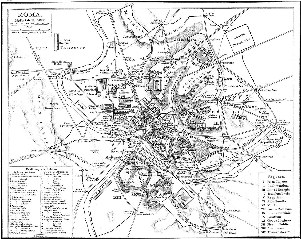
Deutsch: Plan Roms im Altertum
English: Map of Rome during Antiquity
Français : Plan de Rome dans l'Antiquité. Carte issue de l'Allgemeiner Historischer Handatlas de Gustav Droysen dirigé par Richard Andree, 1886. |
| Data | (UTC) |
| Font | |
| Autor |
|
| Això és una imatge retocada, cosa que vol dir que ha estat alterada digitalment de la seva versió original. Modificacions: Changed to greyscale. L'original es pot veure a: Roma Plan.jpg:
|
|
Aquest material està en domini públic als Estats Units i als altres països on el dret d'autor s'estén per 70 anys (o menys) després de la mort de l'autor.
| |
| Aquest fitxer està identificat com a lliure de restriccions conegudes sota la llei de drets d'autor, inclosos els drets veïns. | |
Registre original de càrregues
[modifica]
This image is a derivative work of the following images:
- File:Roma_Plan.jpg licensed with PD-old
- 2008-07-27T06:40:37Z Amadscientist 1840x1463 (3542454 Bytes) {{Information |Description= |Source= |Date= |Author= |Permission= |other_versions= }}
- 2008-07-27T04:57:10Z Amadscientist 4000x3180 (12799554 Bytes) {{Information |Description= |Source= |Date= |Author= |Permission= |other_versions= }}
- 2006-08-28T19:01:08Z Nikephoros 1840x1463 (2624427 Bytes) {{Information |Description=Plan Roms im Altertum / Map of Rome during Antiquity |Source=G. Droysens Allgemeiner Historischer Handatlas |Date=1886 |Author=? |Permission= not needed |other_versions= no }}
Uploaded with derivativeFX
Historial del fitxer
Cliqueu una data/hora per veure el fitxer tal com era aleshores.
| Data/hora | Miniatura | Dimensions | Usuari/a | Comentari | |
|---|---|---|---|---|---|
| actual | 20:00, 20 jul 2010 | | 1.840 × 1.463 (773 Ko) | ChrisO (discussió | contribucions) | {{Information |Description=Plan Roms im Altertum / Map of Rome during Antiquity |Source=*File:Roma_Plan.jpg |Date=2010-07-20 19:59 (UTC) |Author=*File:Roma_Plan.jpg: ? *derivative work: ~~~ |Permission= |other_versions= }} {{RetouchedPicture| |
No podeu sobreescriure aquest fitxer.
Ús del fitxer
La pàgina següent utilitza aquest fitxer: