File:Roman East 50-en.svg
Pereiti į navigaciją
Jump to search

Rinkmenos SVG peržiūros PNG dydisː 800 × 470 taškų. Kitos 6 rezoliucijos: 320 × 188 taškų | 640 × 376 taškų | 1 024 × 601 taškų | 1 280 × 751 taškų | 2 560 × 1 503 taškų | 2 717 × 1 595 taškų.
Pradinė rinkmena (SVG rinkmena, formaliai 2 717 × 1 595 taškų, rinkmenos dydis: 848 KiB)
Captions
Captions
Add a one-line explanation of what this file represents
Aprašymas[keisti]
| Aprašymas |
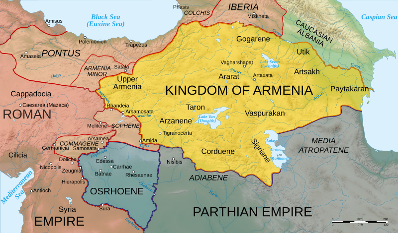
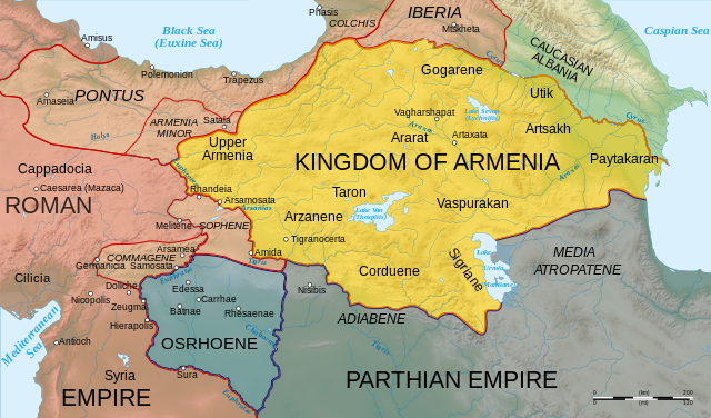
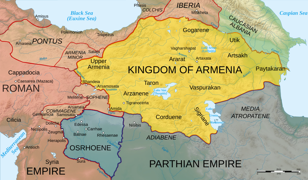
English: Map of Armenia and the Roman client states in eastern Asia Minor, ca. 50 AD, before the Roman-Parthian War and the annexation of the client kingdoms into the Empire. |
| Data | |
| Šaltinis | Based on Image:Arshakuni Armenia 150-en.svg. Province & client state outlines based on: Atlas of Classical History, Routledge 1985, pp. 160-162; History Map of Europe, Year 1 from Euratlas |
| Autorius | Cplakidas |
| Kitos versijos |
[]
|


Šis vektorinis paveikslėlis sukurtas su Inkscape .
Licencija[keisti]
Aš, šio darbo autoriaus teisių savininkas, publikuoju jį su šiomis licencijomis:
Šiam failui taikoma Creative Commons Attribution-Share Alike 3.0 Unported licencija.
- Jūs galite:
- dalintis – kopijuoti, platinti bei persiųsti šį darbą
- pri(si)taikyti – adaptuoti darbą
- Su šiomis sąlygomis:
- autoriaus nurodymas – Turite pateikti atitinkamą kreditą, pateikti nuorodą į licenciją ir nurodyti, ar buvo atlikti pakeitimai. Tai galite padaryti bet kokiu būdu, bet ne taip, kad licencijos išdavėjas patvirtintų jus ar jūsų naudojimą.
- dalinkis panašiai – Jei perdirbsite, redaguosite ar atkursite šį darbą, jį galėsite platinti tik su tokia pačia ar panašia į šią licencija.

|
Suteikiamas leidimas kopijuoti, platinti ir/ar redaguoti šį dokumentą pagal GNU Free Documentation licencijos versijos 1.2 ar bet kurios vėlesnės versijos sąlygas, publikuotas Free Software Foundation; be nekintamų dalių, be priekinių ir galinių tekstinių žymų viršeliuose. Šios licencijos kopija įtraukta dalyje, pavadintoje GNU Free Documentation License. |
Galite pasirinkti, kurią licenciją norite naudoti.
|
Rinkmenos istorija
Paspauskite ant datos/laiko, kad pamatytumėte rinkmeną tokią, kokia ji buvo tuo metu.
| Data/Laikas | Miniatiūra | Matmenys | Naudotojas | Paaiškinimas | |
|---|---|---|---|---|---|
| dabartinis | 14:25, 3 lapkričio 2020 | | 2 717 × 1 595 (848 KiB) | ԱշոտՏՆՂ (aptarimas | indėlis) | The Mingechevir Reservoir was built in 1953, so I removed it from the map. |
| 14:07, 13 balandžio 2009 |  | 2 717 × 1 595 (854 KiB) | Cplakidas (aptarimas | indėlis) | some more details | |
| 06:48, 8 balandžio 2009 |  | 2 717 × 1 595 (849 KiB) | Cplakidas (aptarimas | indėlis) | trying to fix text problems | |
| 14:35, 7 balandžio 2009 |  | 2 717 × 1 595 (863 KiB) | Cplakidas (aptarimas | indėlis) | bigger captions, minor tweaks | |
| 18:52, 6 balandžio 2009 |  | 2 717 × 1 595 (847 KiB) | Cplakidas (aptarimas | indėlis) | plain svg | |
| 18:47, 6 balandžio 2009 |  | 2 717 × 1 595 (858 KiB) | Cplakidas (aptarimas | indėlis) | {{Information |Description={{en|1=Map of Armenia and the Roman client states in eastern Asia Minor, ca. 50 AD, before the Roman-Parthian War and the annexation of the client kingdoms into the Empire.}} |Source=Based on [[:Image:Arshakuni Armenia 150-en.sv |
Jūs negalite perrašyti šios rinkmenos.
Rinkmenos naudojimas
Šie puslapiai naudoja šią rinkmeną:
- Atlas of Artsakh
- User:Cplakidas
- User:Magog the Ogre/Multilingual legend/2020 November 1-10
- File:Roman-Parthian War 58-60-zh.svg
- File:Roman-Parthian War 58-60.svg
- File:Roman-Parthian War 61-63-zh.svg
- File:Roman-Parthian War 61-63.svg
- File:Roman East 50-ang.svg
- File:Roman East 50-en.svg
- File:Roman East 50-es.svg
- File:Roman East 50-he.svg
- File:Roman East 50-hu.svg
- File:Roman East 50-hy.svg
- File:Roman East 50-it.svg
- File:Roman East 50-pt.svg
- File:Roman East 50-zh.svg
- File:Roman East 50 CE Commagene highlighted-en.svg
- Template:Other versions/Roman East 50
Visuotinis rinkmenos naudojimas
Ši rinkmena naudojama šiose viki svetainėse:
- Naudojama ar.wikipedia.org
- Naudojama arz.wikipedia.org
- Naudojama azb.wikipedia.org
- Naudojama az.wikipedia.org
- Naudojama be.wikipedia.org
- Naudojama bg.wikipedia.org
- Naudojama ca.wikipedia.org
- Naudojama cs.wikipedia.org
- Naudojama de.wikipedia.org
- Naudojama el.wikipedia.org
- Naudojama en.wikipedia.org
- Germanicus
- Pontus (region)
- Gaius Caesar
- Osroene
- Wikipedia:WikiProject Former countries
- Kingdom of Armenia (antiquity)
- Vologases I of Parthia
- Armenian nobility
- Tiridates I of Armenia
- User:Mcasey666
- Talk:Kingdom of Armenia (antiquity)
- Kingdom of Pontus
- Wikipedia:Featured pictures/Diagrams, drawings, and maps/Maps
- Roman–Parthian War of 58–63
- User:GroveGuy/Sandbox
- User:Cplakidas/Articles
- User:배우는사람/Test
- Classical Anatolia
- User:HistoryofIran/Shervin II
- Wikipedia:Featured pictures thumbs/39
- Kingdom of Bithynia
- Wikipedia:Featured picture candidates/Greater Armenia
- Wikipedia:Featured picture candidates/February-2014
- User talk:Yerevanci/Archive 3
- User talk:Cplakidas/Archive 15
- Wikipedia:Picture of the day/December 2015
- Template:POTD/2015-12-23
- Wikipedia:Main Page history/2015 December 23
- User talk:Cplakidas/Archive 18
- User talk:Yerevanci/Archive 5
- Wikipedia:WikiProject Former countries/Recognized content
- Wikipedia:WikiProject Armenia/Recognized content
Žiūrėti visuotinį šios rinkmenos naudojimą.
Metaduomenys
Kategorijos:
- Maps of the history of the Caucasus in antiquity
- SVG maps of the history of Armenia
- Maps of the history of Georgia
- SVG maps of the history of Azerbaijan
- Maps of the history of the south Caucasus region
- Maps of Colchis
- Maps of the Kingdom of Iberia
- Maps of Caucasian Albania
- Maps of Corduene
- Maps of Sophene
- Maps of Commagene
- Maps of Osrhoene
- Maps of ancient Anatolia
- Maps of Pontus
- Maps showing 1st-century history
- Limes Orientalis
- Parthian-Roman wars
- SVG maps of the ancient Near East
- English-language SVG maps showing history