File:Roman East 50-en.svg
Przejdź do nawigacji
Przejdź do wyszukiwania

Wielkość pliku podglądu PNG dla pliku SVG: 800 × 470 pikseli Inne rozdzielczości: 320 × 188 pikseli | 640 × 376 pikseli | 1024 × 601 pikseli | 1280 × 751 pikseli | 2560 × 1503 pikseli | 2717 × 1595 pikseli.
Rozmiar pierwotny (Plik SVG, nominalnie 2717 × 1595 pikseli, rozmiar pliku: 848 KB)
Podpisy
Podpisy
Dodaj jednolinijkowe objaśnienie tego, co ten plik pokazuje
Opis[edytuj]
| Opis |
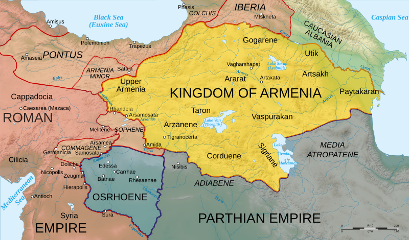
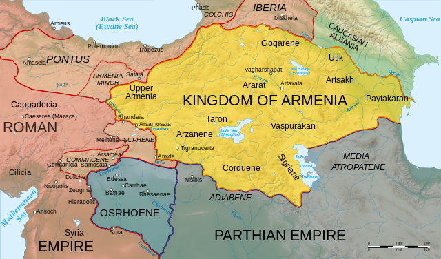
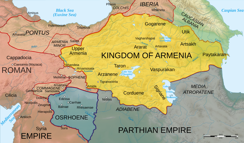
English: Map of Armenia and the Roman client states in eastern Asia Minor, ca. 50 AD, before the Roman-Parthian War and the annexation of the client kingdoms into the Empire. |
| Data | |
| Źródło | Based on Image:Arshakuni Armenia 150-en.svg. Province & client state outlines based on: Atlas of Classical History, Routledge 1985, pp. 160-162; History Map of Europe, Year 1 from Euratlas |
| Autor | Cplakidas |
| Inne wersje |
[]
|


Ta ^specifik^ z W3C grafika wektorowa została stworzona za pomocą Inkscape .
Licencja[edytuj]
Ja, właściciel praw autorskich do tego dzieła, udostępniam je na poniższych licencjach
Ten plik udostępniony jest na licencji Creative Commons Uznanie autorstwa – Na tych samych warunkach 3.0.
- Wolno:
- dzielić się – kopiować, rozpowszechniać, odtwarzać i wykonywać utwór
- modyfikować – tworzyć utwory zależne
- Na następujących warunkach:
- uznanie autorstwa – musisz określić autorstwo utworu, podać link do licencji, a także wskazać czy utwór został zmieniony. Możesz to zrobić w każdy rozsądny sposób, o ile nie będzie to sugerować, że licencjodawca popiera Ciebie lub Twoje użycie utworu.
- na tych samych warunkach – Jeśli zmienia się lub przekształca niniejszy utwór, lub tworzy inny na jego podstawie, można rozpowszechniać powstały w ten sposób nowy utwór tylko na podstawie tej samej lub podobnej licencji.

|
Udziela się zgody na kopiowanie, rozpowszechnianie oraz modyfikowanie tego dokumentu zgodnie z warunkami GNU Licencji Wolnej Dokumentacji, w wersji 1.2 lub nowszej opublikowanej przez Free Software Foundation; bez niezmiennych sekcji, bez treści umieszczonych na frontowej lub tylnej stronie okładki. Kopia licencji załączona jest w sekcji zatytułowanej GNU Licencja Wolnej Dokumentacji. |
Możesz wybrać, którą licencję chcesz zastosować.
|
Historia pliku
Kliknij na odpowiedniej dacie/czasie, aby zobaczyć wersję pliku z tamtego okresu.
| Data/czas | Miniatura | Wymiary | Użytkownik | Opis | |
|---|---|---|---|---|---|
| aktualny | 14:25, 3 lis 2020 | | 2717 × 1595 (848 KB) | ԱշոտՏՆՂ (dyskusja | edycje) | The Mingechevir Reservoir was built in 1953, so I removed it from the map. |
| 14:07, 13 kwi 2009 |  | 2717 × 1595 (854 KB) | Cplakidas (dyskusja | edycje) | some more details | |
| 06:48, 8 kwi 2009 |  | 2717 × 1595 (849 KB) | Cplakidas (dyskusja | edycje) | trying to fix text problems | |
| 14:35, 7 kwi 2009 |  | 2717 × 1595 (863 KB) | Cplakidas (dyskusja | edycje) | bigger captions, minor tweaks | |
| 18:52, 6 kwi 2009 |  | 2717 × 1595 (847 KB) | Cplakidas (dyskusja | edycje) | plain svg | |
| 18:47, 6 kwi 2009 |  | 2717 × 1595 (858 KB) | Cplakidas (dyskusja | edycje) | {{Information |Description={{en|1=Map of Armenia and the Roman client states in eastern Asia Minor, ca. 50 AD, before the Roman-Parthian War and the annexation of the client kingdoms into the Empire.}} |Source=Based on [[:Image:Arshakuni Armenia 150-en.sv |
Nie możesz nadpisać tego pliku.
Lokalne wykorzystanie pliku
Następujące strony korzystają z tego pliku:
- Atlas of Artsakh
- User:Cplakidas
- User:Magog the Ogre/Multilingual legend/2020 November 1-10
- File:Roman-Parthian War 58-60-zh.svg
- File:Roman-Parthian War 58-60.svg
- File:Roman-Parthian War 61-63-zh.svg
- File:Roman-Parthian War 61-63.svg
- File:Roman East 50-ang.svg
- File:Roman East 50-en.svg
- File:Roman East 50-es.svg
- File:Roman East 50-he.svg
- File:Roman East 50-hu.svg
- File:Roman East 50-hy.svg
- File:Roman East 50-it.svg
- File:Roman East 50-pt.svg
- File:Roman East 50-zh.svg
- File:Roman East 50 CE Commagene highlighted-en.svg
- Template:Other versions/Roman East 50
Globalne wykorzystanie pliku
Ten plik jest wykorzystywany także w innych projektach wiki:
- Wykorzystanie na ar.wikipedia.org
- Wykorzystanie na arz.wikipedia.org
- Wykorzystanie na azb.wikipedia.org
- Wykorzystanie na az.wikipedia.org
- Wykorzystanie na be.wikipedia.org
- Wykorzystanie na bg.wikipedia.org
- Wykorzystanie na ca.wikipedia.org
- Wykorzystanie na cs.wikipedia.org
- Wykorzystanie na de.wikipedia.org
- Wykorzystanie na el.wikipedia.org
- Wykorzystanie na en.wikipedia.org
- Germanicus
- Pontus (region)
- Gaius Caesar
- Osroene
- Wikipedia:WikiProject Former countries
- Kingdom of Armenia (antiquity)
- Vologases I of Parthia
- Armenian nobility
- Tiridates I of Armenia
- User:Mcasey666
- Talk:Kingdom of Armenia (antiquity)
- Kingdom of Pontus
- Wikipedia:Featured pictures/Diagrams, drawings, and maps/Maps
- Roman–Parthian War of 58–63
- User:GroveGuy/Sandbox
- User:Cplakidas/Articles
- User:배우는사람/Test
- Classical Anatolia
- User:HistoryofIran/Shervin II
- Wikipedia:Featured pictures thumbs/39
- Kingdom of Bithynia
- Wikipedia:Featured picture candidates/Greater Armenia
- Wikipedia:Featured picture candidates/February-2014
- User talk:Yerevanci/Archive 3
- User talk:Cplakidas/Archive 15
- Wikipedia:Picture of the day/December 2015
- Template:POTD/2015-12-23
- Wikipedia:Main Page history/2015 December 23
- User talk:Cplakidas/Archive 18
- User talk:Yerevanci/Archive 5
- User:Falcaorib
- Wikipedia:WikiProject Former countries/Recognized content
Pokaż listę globalnego wykorzystania tego pliku.
Metadane
Kategorie:
- Maps of the history of the Caucasus in antiquity
- SVG maps of the history of Armenia
- Maps of the history of Georgia
- SVG maps of the history of Azerbaijan
- Maps of the history of the south Caucasus region
- Maps of Colchis
- Maps of the Kingdom of Iberia
- Maps of Caucasian Albania
- Maps of Corduene
- Maps of Sophene
- Maps of Commagene
- Maps of Osrhoene
- Maps of ancient Anatolia
- Maps of Pontus
- Maps showing 1st-century history
- Limes Orientalis
- Parthian-Roman wars
- SVG maps of the ancient Near East
- English-language SVG maps showing history