File:Roman Empire 125 general map.SVG
Salta a la navegació
Salta a la cerca

Mida d'aquesta previsualització PNG del fitxer SVG: 721 × 599 píxels. Altres resolucions: 289 × 240 píxels | 578 × 480 píxels | 924 × 768 píxels | 1.232 × 1.024 píxels | 2.464 × 2.048 píxels | 2.186 × 1.817 píxels.
Fitxer original (fitxer SVG, nominalment 2.186 × 1.817 píxels, mida del fitxer: 1,77 Mo)
Llegendes
Llegendes
Afegeix una explicació d'una línia del que representa aquest fitxer
| Posició de la càmera | | Aquesta i altres imatges properes a: OpenStreetMap |
|---|
Resum
[modifica]| Descripció |
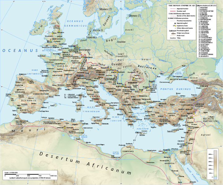
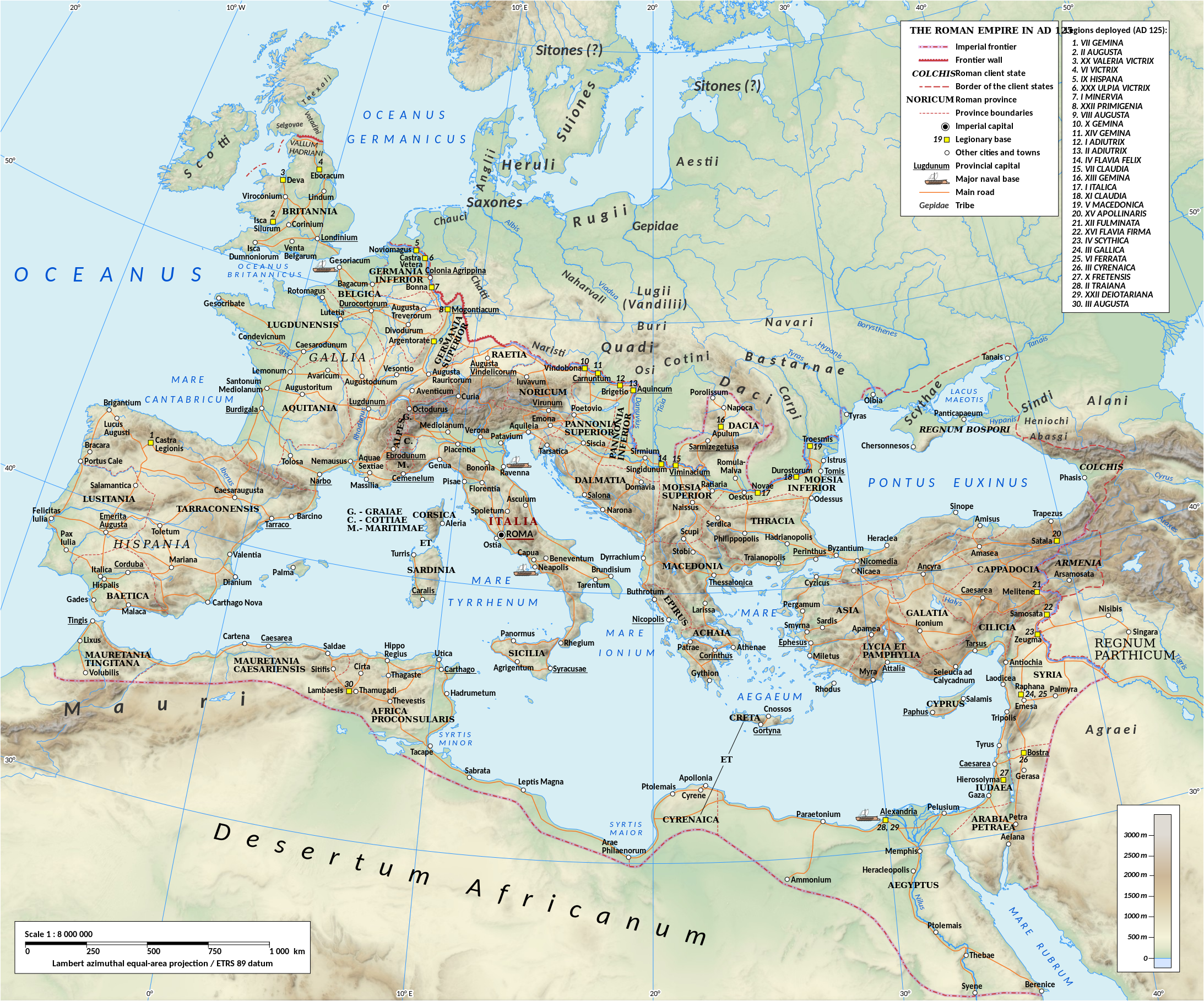
English: Map of the Roman Empire in 125.
Projection Lambert azimuthal-equal area. Central latitude: 45° N, central longitude: 20° E. X, Y origin offset - 0 Datum: ETRS89 Sources The physical map was made using the following public domain sources:
Additional references for the map content:
Software used GIS:
Graphics editors:
|
| Data | |
| Font | Treball propi |
| Autor | User:ArdadN & reviewer - User:EraNavigator |
| Altres versions |
[]
|


Llicència
[modifica]
Jo, el titular dels drets d'autor d'aquest treball, el public sota les següents llicències:
Aquest fitxer està subjecte a la llicència de Creative Commons Reconeixement i Compartir Igual 3.0 No adaptada.
- Sou lliure de:
- compartir – copiar, distribuir i comunicar públicament l'obra
- adaptar – fer-ne obres derivades
- Amb les condicions següents:
- reconeixement – Heu de donar la informació adequada sobre l'autor, proporcionar un enllaç a la llicència i indicar si s'han realitzat canvis. Podeu fer-ho amb qualsevol mitjà raonable, però de cap manera no suggereixi que l'autor us dóna suport o aprova l'ús que en feu.
- compartir igual – Si modifiqueu, transformeu, o generareu amb el material, haureu de distribuir les vostres contribucions sota una llicència similar o una de compatible com l'original

|
S'autoritza la còpia, la distribució i la modificació d'aquest document sota els termes de la llicència de documentació lliure GNU versió 1.2 o qualsevol altra versió posterior que publiqui la Free Software Foundation; sense seccions invariants, ni textos de portada, ni textos de contraportada. S'inclou una còpia d'aquesta llicència en la secció titulada GNU Free Documentation License. |
Podeu seleccionar la llicència que vulgueu.
_en.png)
.png)
.jpg)
Historial del fitxer
Cliqueu una data/hora per veure el fitxer tal com era aleshores.
| Data/hora | Miniatura | Dimensions | Usuari/a | Comentari | |
|---|---|---|---|---|---|
| actual | 12:34, 30 gen 2024 | | 2.186 × 1.817 (1,77 Mo) | ArdadN (discussió | contribucions) | removed author caption |
| 18:13, 1 gen 2023 |  | 2.186 × 1.817 (1,77 Mo) | Bkell (discussió | contribucions) | fix typo: Pahpus → Paphus | |
| 05:24, 19 oct 2020 |  | 2.186 × 1.817 (1,77 Mo) | Artoria2e5 (discussió | contribucions) | Reduce file size by using a JPEG relief instead (4:2:0 Q90 Progressive, no metadata/ICC/thumbnail). | |
| 18:16, 20 jul 2015 |  | 2.186 × 1.817 (5,84 Mo) | ArdadN (discussió | contribucions) | 1 | |
| 17:54, 20 jul 2015 |  | 2.186 × 1.817 (5,85 Mo) | ArdadN (discussió | contribucions) | 1 | |
| 17:05, 3 març 2015 |  | 2.186 × 1.817 (5,85 Mo) | ArdadN (discussió | contribucions) | new road added | |
| 13:48, 10 feb 2015 |  | 2.186 × 1.817 (5,86 Mo) | ArdadN (discussió | contribucions) | 1 | |
| 18:46, 20 maig 2014 |  | 2.186 × 1.817 (5,85 Mo) | ArdadN (discussió | contribucions) | 1 | |
| 18:33, 9 abr 2014 |  | 2.186 × 1.817 (5,85 Mo) | ArdadN (discussió | contribucions) | scotti | |
| 15:43, 30 març 2014 |  | 2.186 × 1.817 (5,85 Mo) | ArdadN (discussió | contribucions) | 1 |
No podeu sobreescriure aquest fitxer.
Ús del fitxer
Les 22 pàgines següents utilitzen aquest fitxer:
- User:Chumwa/OgreBot/Transport Maps/2015 February 10-18
- User:Chumwa/OgreBot/Transport Maps/2015 July 11-20
- User:Chumwa/OgreBot/Transport Maps/2015 March 1-10
- User:Chumwa/OgreBot/Transport Maps/2020 October 11-20
- User:Chumwa/OgreBot/Transport Maps/2023 January 1-10
- User:Chumwa/OgreBot/Transport Maps/2024 January 21-31
- User:Chumwa/OgreBot/Travel and communication maps/2020 October 11-20
- User:Chumwa/OgreBot/Travel and communication maps/2023 January 1-10
- User:Chumwa/OgreBot/Travel and communication maps/2024 January 21-31
- Commons:Graphic Lab/Map workshop/Archive/2021
- File:Roman Empire 125.png
- File:Roman Empire 125 general map-zh.png
- File:Roman Empire 125 general map-zh.svg
- File:Roman Empire 125 general map.SVG
- File:Roman Empire 125 general map pl.svg
- File:Roman Empire 125 political map-de.svg
- File:Roman Empire 125 political map-zh.png
- File:Roman Empire 125 political map-zh.svg
- File:Roman Empire 125 political map.png
- File:Roman Empire 125 political map.svg
- File:Roman Empire 125 political map pl.svg
- Template:Other versions/Roman Empire 125 map
Ús global del fitxer
Utilització d'aquest fitxer en altres wikis:
- Utilització a ca.wikipedia.org
- Utilització a el.wikipedia.org
- Utilització a en.wikipedia.org
- Utilització a fr.wikipedia.org
- Utilització a la.wikipedia.org
- Utilització a ru.wikipedia.org
Metadades
Categories:
- Maps of the Roman Empire in 125 AD
- SVG maps of the Roman Empire
- Maps of the history of Romania in ancient times
- Maps of Dacian tribes
- Maps of Roman Dacia
- Maps of ancient Roman roads
- 125 in Europe
- Historical maps of the Carpathian Mountains
- Pomerania in the 1st century
- Oksywie culture
- Wielbark culture maps
- Poland in the 1st century
- Pomerania in the 2nd century
- Poland in the 2nd century
- Bastarnae
- Burgundians
- Carpi people
- Costoboci
- Maps of the Gepids
- Maps of the Goths
- Hasdingi
- Iazyges
- Marcomanni
- Quadi
- Maps of the Rugii
- Maps of the Scythians
- Silingi
- Maps of the Vandals