File:Roman Empire 125 political map.png
跳至導覽
跳至搜尋

預覽大小:721 × 599 像素。 其他解析度:289 × 240 像素 | 578 × 480 像素 | 924 × 768 像素 | 1,232 × 1,024 像素 | 2,186 × 1,817 像素。
原始檔案 (2,186 × 1,817 像素,檔案大小:3.21 MB,MIME 類型:image/png)
說明
說明
添加單行說明來描述出檔案所代表的內容
te
| 拍攝地點 | | 位於此地的本圖片與其他圖片: OpenStreetMap |
|---|
摘要[編輯]
| 描述 |
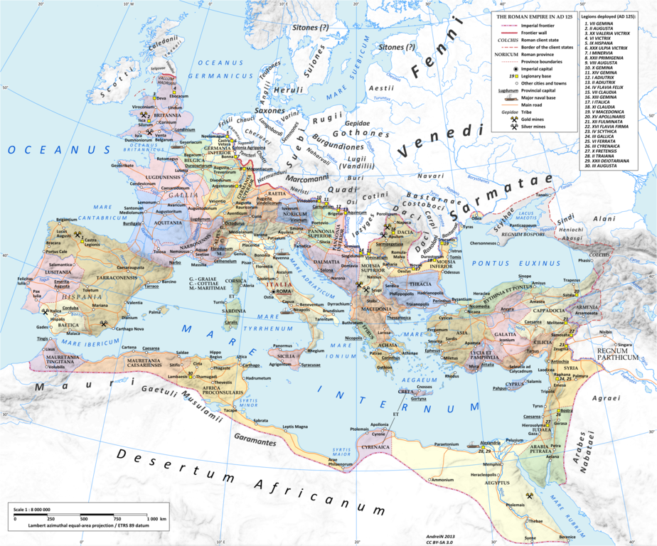
English: Map of the Roman Empire in 125 during the reign of emperor Hadrian.
Projection Lambert azimuthal-equal area. Central latitude: 45° N, central longitude: 20° E. X, Y origin offset - 0 Datum: ETRS89 Sources The physical map was made using the following public domain sources:
Additional references for the map content:
Software used GIS:
Graphics editors:
|
|||
| 日期 | ||||
| 來源 | 自己的作品 | |||
| 作者 | User:Andrein, with the assistance of EraNavigator | |||
| 授權許可 (重用此檔案) |
Any use of this map can be made as long as you credit me (Andrei N. – Wikimedia Commons user: Andrein) as the author and distribute the copies and derivative works under the same license as that the one stated below. | |||
| 其他版本 |
[]
|


授權條款[編輯]
我,本作品的著作權持有者,決定用以下授權條款發佈本作品:
此檔案採用共享創意 姓名標示-相同方式分享 3.0 未在地化版本授權條款。
- 您可以自由:
- 分享 – 複製、發佈和傳播本作品
- 重新修改 – 創作演繹作品
- 惟需遵照下列條件:
- 姓名標示 – 您必須指名出正確的製作者,和提供授權條款的連結,以及表示是否有對內容上做出變更。您可以用任何合理的方式來行動,但不得以任何方式表明授權條款是對您許可或是由您所使用。
- 相同方式分享 – 如果您利用本素材進行再混合、轉換或創作,您必須基於如同原先的相同或兼容的條款,來分布您的貢獻成品。

|
已授權您依據自由軟體基金會發行的無固定段落、封面文字和封底文字GNU自由文件授權條款1.2版或任意後續版本,對本檔進行複製、傳播和/或修改。該協議的副本列在GNU自由文件授權條款中。 |
您可以選擇您需要的授權條款。
_en.png)
.png)
.jpg)
檔案歷史
點選日期/時間以檢視該時間的檔案版本。
| 日期/時間 | 縮圖 | 尺寸 | 用戶 | 備註 | |
|---|---|---|---|---|---|
| 目前 | 2015年7月20日 (一) 18:14 | | 2,186 × 1,817(3.21 MB) | ArdadN(對話 | 貢獻) | 1 |
| 2015年7月20日 (一) 17:49 |  | 2,186 × 1,817(3.21 MB) | ArdadN(對話 | 貢獻) | 1 | |
| 2015年3月3日 (二) 18:46 |  | 2,186 × 1,817(3.21 MB) | ArdadN(對話 | 貢獻) | fixing text problems | |
| 2015年3月3日 (二) 17:05 |  | 2,186 × 1,817(3.18 MB) | ArdadN(對話 | 貢獻) | new road added | |
| 2015年2月10日 (二) 13:50 |  | 2,186 × 1,817(3.21 MB) | ArdadN(對話 | 貢獻) | 1 | |
| 2014年5月20日 (二) 18:44 |  | 2,186 × 1,817(3.2 MB) | ArdadN(對話 | 貢獻) | 1 | |
| 2014年4月9日 (三) 18:19 |  | 2,186 × 1,817(3.2 MB) | ArdadN(對話 | 貢獻) | Scotti | |
| 2014年4月4日 (五) 19:26 |  | 2,186 × 1,817(3.2 MB) | ArdadN(對話 | 貢獻) | 1 | |
| 2014年3月30日 (日) 11:47 |  | 2,186 × 1,817(3.19 MB) | ArdadN(對話 | 貢獻) | removed Scotti, other minor edits | |
| 2013年5月12日 (日) 14:27 |  | 2,186 × 1,817(3.21 MB) | ArdadN(對話 | 貢獻) | 1 |
無法覆蓋此檔案。
檔案用途
下列16個頁面有用到此檔案:
- User:Chumwa/OgreBot/Transport Maps/2015 February 10-18
- User:Chumwa/OgreBot/Transport Maps/2015 July 11-20
- User:Chumwa/OgreBot/Transport Maps/2015 March 1-10
- Commons:Graphic Lab/Map workshop/Archive/2021
- File:Roman Empire 125.png
- File:Roman Empire 125 general map-zh.png
- File:Roman Empire 125 general map-zh.svg
- File:Roman Empire 125 general map.SVG
- File:Roman Empire 125 general map pl.svg
- File:Roman Empire 125 political map-de.svg
- File:Roman Empire 125 political map-zh.png
- File:Roman Empire 125 political map-zh.svg
- File:Roman Empire 125 political map.png
- File:Roman Empire 125 political map.svg
- File:Roman Empire 125 political map pl.svg
- Template:Other versions/Roman Empire 125 map
全域檔案使用狀況
以下其他 wiki 使用了這個檔案:
- af.wikipedia.org 的使用狀況
- bn.wikipedia.org 的使用狀況
- en.wikipedia.org 的使用狀況
- et.wikipedia.org 的使用狀況
- gl.wikipedia.org 的使用狀況
- hu.wikipedia.org 的使用狀況
- id.wikipedia.org 的使用狀況
- it.wikipedia.org 的使用狀況
- ko.wikipedia.org 的使用狀況
- mk.wikipedia.org 的使用狀況
- mr.wikipedia.org 的使用狀況
- ms.wikipedia.org 的使用狀況
- pt.wikipedia.org 的使用狀況
詮釋資料
分類:
- Maps of the Roman Empire in 125 AD
- Administrative maps of the Roman Empire
- Maps of the history of Romania in ancient times
- Maps of the European Antiquity
- Maps of Dacian tribes
- Maps of Roman Dacia
- Maps of ancient Roman roads
- 125 in Europe
- Historical maps of the Carpathian Mountains
- Pomerania in the 1st century
- Oksywie culture
- Wielbark culture maps
- Poland in the 1st century
- Pomerania in the 2nd century
- Poland in the 2nd century
- Bastarnae
- Burgundians
- Carpi people
- Costoboci
- Maps of the Gepids
- Maps of the Goths
- Hasdingi
- Iazyges
- Marcomanni
- Quadi
- Maps of the Rugii
- Maps of the Scythians
- Silingi
- Maps of the Vandals