File:Roman regioVII etruria.jpg
Jump to navigation
Jump to search
Size of this preview: 546 × 599 pixels. Other resolutions: 219 × 240 pixels | 437 × 480 pixels | 731 × 802 pixels.
Original file (731 × 802 pixels, file size: 256 KB, MIME type: image/jpeg)
Captions
Captions
Add a one-line explanation of what this file represents
Summary
[edit]
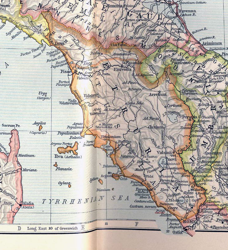
| Description | Map of Etruria during the Roman period. |
| Source | http://www.lib.utexas.edu/maps/historical/shepherd_1911/shepherd-c-030-031.jpg |
| Author | The Historical Atlas by William R. Shepherd, 1911. |
| Permission (Reusing this file) |
Public domain |
| Other versions | Extracted and adapted from The Historical Atlas by William R. Shepherd, 1911. |
Licensing
[edit]
This media file is in the public domain in the United States. This applies to U.S. works where the copyright has expired, often because its first publication occurred prior to January 1, 1929, and if not then due to lack of notice or renewal. See this page for further explanation.
|
 | |
 |
This image might not be in the public domain outside of the United States; this especially applies in the countries and areas that do not apply the rule of the shorter term for US works, such as Canada, Mainland China (not Hong Kong or Macao), Germany, Mexico, and Switzerland. The creator and year of publication are essential information and must be provided. See Wikipedia:Public domain and Wikipedia:Copyrights for more details.
|
File history
Click on a date/time to view the file as it appeared at that time.
| Date/Time | Thumbnail | Dimensions | User | Comment | |
|---|---|---|---|---|---|
| current | 14:58, 18 August 2007 | | 731 × 802 (256 KB) | Goldwin~commonswiki (talk | contribs) | {{Information |Description=Map of Etruria during the Roman period. |Source=http://www.lib.utexas.edu/maps/historical/shepherd_1911/shepherd-c-030-031.jpg |Date= |Author=The Historical Atlas by William R. Shepherd, 1911. |Permission=Public domain |other_ve |
You cannot overwrite this file.
File usage on Commons
There are no pages that use this file.
File usage on other wikis
The following other wikis use this file:
- Usage on co.wikipedia.org
- Usage on cs.wikipedia.org
- Usage on es.wikipedia.org
- Usage on hy.wikipedia.org
- Usage on it.wikipedia.org
- Siena
- Tarquinia
- Cerveteri
- Tuscania
- Sutri
- Blera
- Cortona
- Chiusi
- Volterra
- Regio VII Etruria
- Veio
- Saturnia
- Falerii
- Vulci
- Civitavecchia
- Lucus Feroniae
- Bisenzio (sito archeologico)
- Florentia
- Talamone
- Porto Pisano
- Roselle (sito archeologico)
- Cosa (colonia romana)
- Pyrgi
- Ferento
- Statonia
- Sovana (sito archeologico)
- Caere
- Lucca
- Vada (Rosignano Marittimo)
- Vetulonia (sito archeologico)
- Storia della Toscana
- Città romane
- Arezzo
- Monumento naturale di Galeria Antica
- Luna (colonia romana)
- Alsium
- Siti archeologici dell'Italia antica
- Valvata
- Template:Città romane della Regio VII Etruria
- Usage on pt.wikipedia.org
- Usage on ru.wikipedia.org
- Usage on www.wikidata.org