File:Rome urban zones Municipio VI locator map.svg
Jump to navigation
Jump to search

Size of this PNG preview of this SVG file: 795 × 437 pixels. Other resolutions: 320 × 176 pixels | 640 × 352 pixels | 1,024 × 563 pixels | 1,280 × 704 pixels | 2,560 × 1,407 pixels.
Original file (SVG file, nominally 795 × 437 pixels, file size: 72 KB)
Captions
Captions
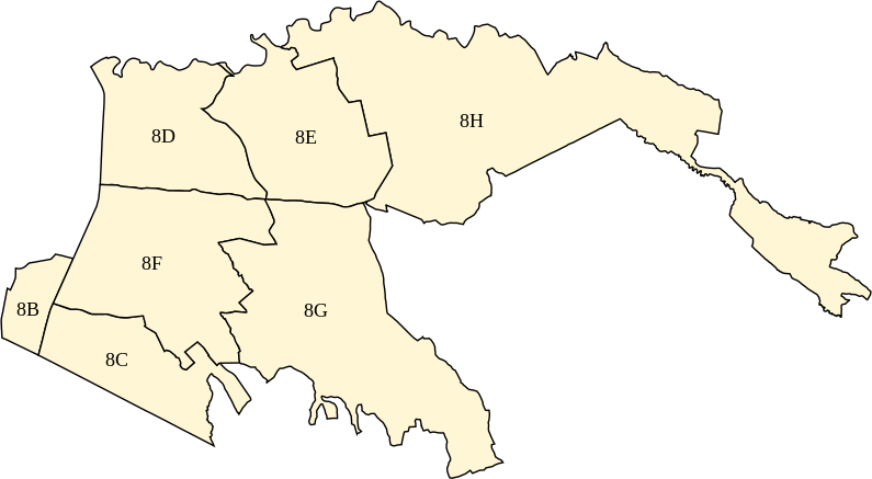
Map of the urban zones of Rome's Municipio VI
Summary[edit]
| Description |
Italiano: Mappa delle zone urbanistiche del Municipio Roma VI
English: Map of the urban zones of Rome's Municipio VI |
| Date | |
| Source | Own work |
| Author | Sannita |
Licensing[edit]
I, the copyright holder of this work, hereby publish it under the following license:
This file is licensed under the Creative Commons Attribution-Share Alike 4.0 International license.
- You are free:
- to share – to copy, distribute and transmit the work
- to remix – to adapt the work
- Under the following conditions:
- attribution – You must give appropriate credit, provide a link to the license, and indicate if changes were made. You may do so in any reasonable manner, but not in any way that suggests the licensor endorses you or your use.
- share alike – If you remix, transform, or build upon the material, you must distribute your contributions under the same or compatible license as the original.
File history
Click on a date/time to view the file as it appeared at that time.
| Date/Time | Thumbnail | Dimensions | User | Comment | |
|---|---|---|---|---|---|
| current | 20:44, 4 October 2021 | | 795 × 437 (72 KB) | Sannita (talk | contribs) | updating map (zone 8A is now in 7th municipality) + better resolution |
| 12:39, 23 February 2021 |  | 848 × 438 (71 KB) | Sannita (talk | contribs) | enlarging map | |
| 12:31, 23 February 2021 |  | 345 × 178 (71 KB) | Sannita (talk | contribs) | Uploaded own work with UploadWizard |
You cannot overwrite this file.
File usage on Commons
The following page uses this file:
File usage on other wikis
The following other wikis use this file:
- Usage on it.wikipedia.org