File:Rotorua.Caldera.Mount.Tarawera.JPG
Originaldatei (1.280 × 948 Pixel, Dateigröße: 399 KB, MIME-Typ: image/jpeg)
Bildtexte
Kurzbeschreibungen
| Beschreibung |
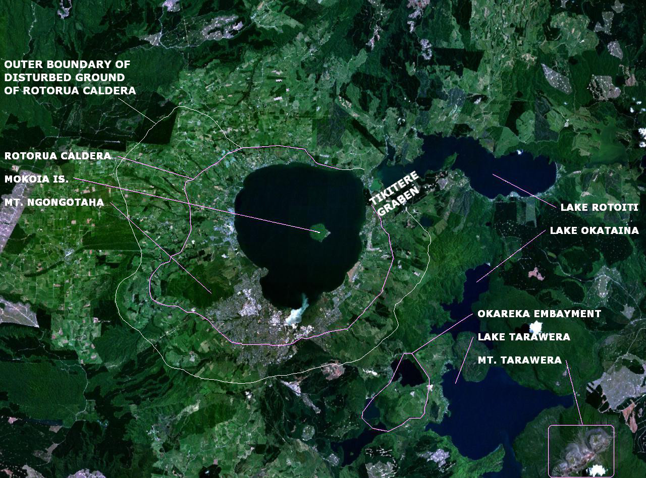
English: en:NASA World Wind false-colour landsat-7 composite satellite photo of en:Lake Rotorua in en:New Zealand. en:Category:Taupo Volcanic Zone |
| Datum | (UTC) |
| Quelle | |
| Urheber |
|
Annotations based on: Newhall, Christopher G.; Dzurisin, Daniel (1988), Historical unrest at large calderas of the world, USGS Bulletin 1855, p. 1108 [1] Archivkopie in der Wayback Machine; Hodgson, K. A. and Nairn, I. A. (2004). The Sedimentation and Drainage History of Haroharo Caldera and The Tarawera River System, Taupo Volcanic Zone, New Zealand, Operations Publication 2004/03, Environment Bay of Plenty, August 2004. ISSN 1176 - 5550. Page 7.[2]. Corrections based on Milner,David M. The structure and eruptive history of Rotorua Caldera, Taupo Volcanic Zone, New Zealand (2001).
| Dieses Bild wurde digital nachbearbeitet. Folgende Änderungen wurden vorgenommen: Labels. Das Originalbild kann hier eingesehen werden: Lake rotorua.jpg:
|
| Diese Datei ist gemeinfrei (Public Domain), da es sich um einen Screenshot der NASA-Software World Wind handelt, in der ein gemeinfreier Datensatz wie Blue Marble, MODIS, Landsat, SRTM, USGS oder GLOBE verwendet wird.
|
 |
Ursprüngliches Datei-Logbuch[Bearbeiten]
This image is a derivative work of the following images:
- File:Lake_rotorua.jpg licensed with PD-USGov-NASA
- 2008-01-03T16:16:53Z Rémih 1280x948 (227865 Bytes) {{Information |Description={{en|[[:en:NASA World Wind]] false-colour landsat-7 composite satellite photo of [[:en:Lake Rotorua]] in [[:en:New Zealand]]. [[:en:Category:Taupo Volcanic Zone]]}} |Source=Transfered from [http://e
Hochgeladen mit derivativeFX
Dateiversionen
Klicke auf einen Zeitpunkt, um diese Version zu laden.
| Version vom | Vorschaubild | Maße | Benutzer | Kommentar | |
|---|---|---|---|---|---|
| aktuell | 19:33, 14. Aug. 2022 | | 1.280 × 948 (399 KB) | ChaseKiwi (Diskussion | Beiträge) | Caldera outline corrected, Tikitere Graben added to explain gap in Caldera |
| 09:38, 25. Feb. 2010 |  | 1.280 × 948 (238 KB) | Chris.urs-o (Diskussion | Beiträge) | Improved labelling | |
| 20:22, 24. Feb. 2010 |  | 1.280 × 948 (235 KB) | Chris.urs-o (Diskussion | Beiträge) | {{Information |Description={{en|en:NASA World Wind false-colour landsat-7 composite satellite photo of en:Lake Rotorua in en:New Zealand. en:Category:Taupo Volcanic Zone}} |Source=*File:Lake_rotorua.jpg |Date=2010-02-24 20:15 (UT |
Du kannst diese Datei nicht überschreiben.
Dateiverwendung
Keine Seiten verwenden diese Datei.
Globale Dateiverwendung
Die nachfolgenden anderen Wikis verwenden diese Datei:
- Verwendung auf de.wikipedia.org
- Verwendung auf en.wikipedia.org
- Verwendung auf it.wikipedia.org
Metadaten
- Lake Rotorua
- Mount Tarawera
- Satellite pictures of the Bay of Plenty Region
- Lake Tarawera
- NASA World Wind
- False-color satellite images
- Calderas in New Zealand
- Maps of the Taupo Volcanic Zone
- Nested calderas
- Geological maps of New Zealand
- Rotorua Caldera
- Maps of volcanoes in New Zealand
- Grabens (geology) in New Zealand
- Volcanoes in New Zealand (annotated)
- Volcanological maps of New Zealand
- Lake Rotoiti (Bay of Plenty)
- Lake Okataina
- Tikitere Graben
- Mount Ngongotaha
- Mokoia Island