File:Route Enghien-les-Bains à Saint-Denis - chemin d'Epinay à Stains XVIIIe.jpg
Jump to navigation
Jump to search

Size of this preview: 800 × 372 pixels. Other resolutions: 320 × 149 pixels | 640 × 298 pixels | 1,024 × 476 pixels | 1,280 × 595 pixels | 2,560 × 1,191 pixels | 9,528 × 4,431 pixels.
Original file (9,528 × 4,431 pixels, file size: 5.22 MB, MIME type: image/jpeg)
Captions
Captions
Add a one-line explanation of what this file represents
Summary[edit]
| Title |
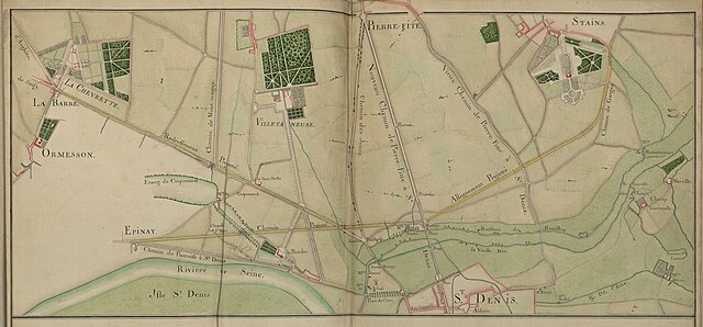
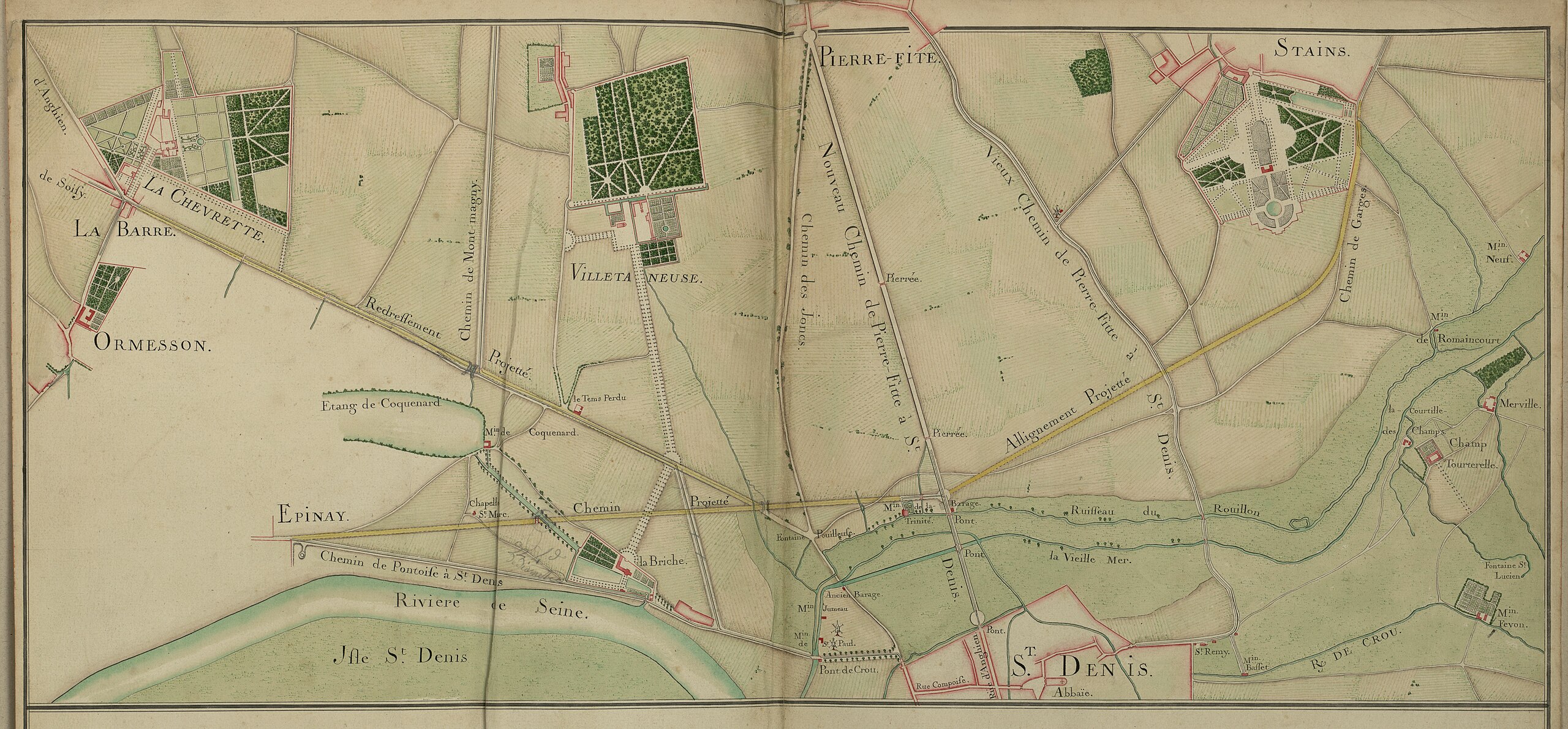
Français : Portion de route en provenance d'Enghein-les-Bains ("Anghien") et de Soisy-sous-Montmorency ("Soisy"), faisant un embranchement à "La-Chevrette" et "La-Barre", non loin d'"Ormesson", rejoignant à "Saint-Denis" le chemin projeté en provenance d'"Epinay", et allant à "Stains" après le croisement avec le nouveau et le vieux chemin de Pierrefitte-sur-Seine ("Pierre-Fitte") à "Saint-Denis". |
||||||||||||||||||||
| Description |
Portion de route en provenance d'Enghein-les-Bains ("Anghien") et de Soisy-sous-Montmorency ("Soisy"), faisant un embranchement à "La-Chevrette" et "La-Barre", non loin d'"Ormesson", rejoignant à "Saint-Denis" le chemin projeté en provenance d'"Epinay", et allant à "Stains" après le croisement avec le nouveau et le vieux chemin de Pierrefitte-sur-Seine ("Pierre-Fitte") à "Saint-Denis". |
||||||||||||||||||||
| Date | XVIIIe | ||||||||||||||||||||
| Collection |
|
||||||||||||||||||||
| Accession number |
CP/F/14/8444, Planche 56 |
||||||||||||||||||||
| References | notice en ligne | ||||||||||||||||||||
| Source | Archives nationales | ||||||||||||||||||||

Licensing[edit]
| This file is licensed under the Licence Ouverte 1.0 (License text, English license text).
|
| Object location | | View this and other nearby images on: OpenStreetMap |
|---|
File history
Click on a date/time to view the file as it appeared at that time.
| Date/Time | Thumbnail | Dimensions | User | Comment | |
|---|---|---|---|---|---|
| current | 12:02, 19 July 2023 | | 9,528 × 4,431 (5.22 MB) | Archives nationales (France) (talk | contribs) | ajout media AN pour editathon 2023 (details) |
You cannot overwrite this file.
File usage on Commons
The following page uses this file:
Metadata
Categories:
- Media contributed by the Archives Nationales (France)/17
- 18th century documents in the Archives nationales (France)
- Atlas de Trudaine
- Stains (Seine-Saint-Denis) in the Archives nationales (France)
- Epinay-sur-Seine (Seine-Saint-Denis) in the Archives nationales (France)
- Pierrefitte-sur-Seine (Seine-Saint-Denis) in the Archives nationales (France)
- Saint-Denis (Seine-Saint-Denis) in the Archives nationales (France)
- Old maps of Seine-Saint-Denis
- Files with coordinates missing SDC location of creation (48° N, 2°E)