File:Rozières-sur-Crise (Aisne) mairie.JPG
Here nagîvasyonê
Here lêgerînê

Mezinahiya vê pêşdîtinê: 800 × 600 pîksel. Resolusyonên din: 320 × 240 pîksel | 640 × 480 pîksel | 1024 × 768 pîksel | 1280 × 960 pîksel | 2560 × 1920 pîksel | 3648 × 2736 pîksel.
Dosyeya orjînal (3648 × 2736 pixel, mezinbûnê data: 3,98 MB, MIME-typ: image/jpeg)
Captions
Captions
Add a one-line explanation of what this file represents
Danasîn[biguhêre]
_mairie.JPG&action=edit§ion=1)
| Danasîn |
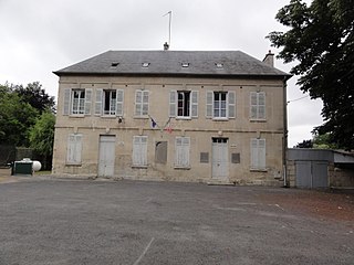
English: Rozières-sur-Crise (Aisne) mairie |
| Dîrok | |
| Çavkanî | Min çêkir |
| Xwedî | Havang(nl) |
| Şûnda kamerayê | | Ev wêne û yên din li ser OpenStreetMap |
|---|
_mairie.JPG¶ms=049.325947_N_0003.355145_E_globe:Earth_type:camera_heading:278.50&language=ku-latn)
The geographical information in this file was retrospectively estimated.
The location may therefore be somewhat imprecise. Verifying and refining these coordinates is strongly encouraged. |
Lîsans[biguhêre]
_mairie.JPG&action=edit§ion=2)
I, the copyright holder of this work, hereby publish it under the following license:
| This file is made available under the Creative Commons CC0 1.0 Universal Public Domain Dedication. | |
| The person who associated a work with this deed has dedicated the work to the public domain by waiving all of their rights to the work worldwide under copyright law, including all related and neighboring rights, to the extent allowed by law. You can copy, modify, distribute and perform the work, even for commercial purposes, all without asking permission.
|
This image was uploaded as part of L'Été des villes 2015.
|
The making of this document was supported by Wikimédia France. (Submit your project!)
|
Dîroka daneyê
Ji bo dîtina guhartoya wê demê bişkoka dîrokê bitikîne.
| Dîrok/Katjimêr | Wêneyê biçûk | Mezinahî | Bikarhêner | Şirove | |
|---|---|---|---|---|---|
| niha | 10:05, 12 tîrmeh 2015 | | 3648 x 2736 (3,98 MB) | Havang(nl) (gotûbêj | beşdarî) | User created page with UploadWizard |
Tu nikarî cardin li ser vê dosyeyê binivîsînî.
Bikaranîna pelê
Ev 4 rûpel li jêr vê dosyeyê bi kar tînin:
Bikaranîna gerdûnî ya pelê
Ev wîkiyên di rêzê de vê pelê bi kar tînin:
- Bikaranîna di ast.wikipedia.org de
- Bikaranîna di ca.wikipedia.org de
- Bikaranîna di ceb.wikipedia.org de
- Bikaranîna di ce.wikipedia.org de
- Bikaranîna di de.wikipedia.org de
- Bikaranîna di diq.wikipedia.org de
- Bikaranîna di en.wikipedia.org de
- Bikaranîna di eu.wikipedia.org de
- Bikaranîna di hy.wikipedia.org de
- Bikaranîna di it.wikipedia.org de
- Bikaranîna di ku.wikipedia.org de
- Bikaranîna di pl.wikipedia.org de
- Bikaranîna di pt.wikipedia.org de
- Bikaranîna di ro.wikipedia.org de
- Bikaranîna di ru.wikipedia.org de
- Bikaranîna di sk.wikipedia.org de
- Bikaranîna di sv.wikipedia.org de
- Bikaranîna di tt.wikipedia.org de
- Bikaranîna di uk.wikipedia.org de
- Bikaranîna di uz.wikipedia.org de
- Bikaranîna di vec.wikipedia.org de
- Bikaranîna di www.wikidata.org de
- Bikaranîna di zh-min-nan.wikipedia.org de
- Bikaranîna di zh-yue.wikipedia.org de
- Bikaranîna di zh.wikipedia.org de
_mairie.JPG&oldid=811372914)