File:Rue du Puits-Vert (Toulouse).jpg
Jump to navigation
Jump to search

Size of this preview: 432 × 600 pixels. Other resolutions: 173 × 240 pixels | 346 × 480 pixels | 553 × 768 pixels | 738 × 1,024 pixels | 1,475 × 2,048 pixels | 4,614 × 6,404 pixels.
Original file (4,614 × 6,404 pixels, file size: 23.19 MB, MIME type: image/jpeg)
Captions
Captions
Add a one-line explanation of what this file represents
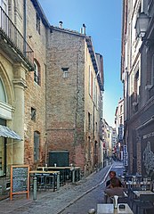
Rue du Puits-Vert (Toulouse) - Viewed in its entirety from the rue Baronie to rue saint Rome.
Summary
[edit]| Description |
English: Rue du Puits-Vert, in Toulouse - Viewed in its entirety from the rue Baronie to rue saint Rome. Français : Rue du Puits-Vert, à Toulouse - Vue en totalité depuis La rue Baronie à la rue saint Rome. |
| Date | Taken on 5 October 2017 |
| Source | Own work |
| Author | Didier Descouens |
| Permission (Reusing this file) |
I, the copyright holder of this work, hereby publish it under the following license: This file is licensed under the Creative Commons Attribution-Share Alike 4.0 International license.
|
| Other versions |
|
.jpg)
_debut.jpg)
_-_Plaques.jpg)
.jpg&action=edit§ion=1)
| Camera location | | View this and other nearby images on: OpenStreetMap |
|---|
.jpg¶ms=043.601713_N_0001.443484_E_globe:Earth_type:camera_alt:538.5_source:exif_&language=en)
| Annotations | This image is annotated: View the annotations at Commons |
.jpg)

|
This image has been assessed under the valued image criteria and is considered the most valued image on Commons within the scope: Rue du Puits-Vert (Toulouse) - Viewed in its entirety from the rue Baronie to rue saint Rome.. You can see its nomination here. |
.jpg)
File history
Click on a date/time to view the file as it appeared at that time.
| Date/Time | Thumbnail | Dimensions | User | Comment | |
|---|---|---|---|---|---|
| current | 15:40, 12 October 2017 | | 4,614 × 6,404 (23.19 MB) | Archaeodontosaurus (talk | contribs) | {{Information |Description ={{en|1=cb}} |Source ={{own}} |Author =Archaeodontosaurus |Date = |Permission = |other_versions = }} |
You cannot overwrite this file.
File usage on Commons
The following 6 pages use this file:
File usage on other wikis
The following other wikis use this file:
- Usage on fr.wikipedia.org
- Usage on www.wikidata.org
.jpg&oldid=820762215)