File:Russian drone Cartographer, downed in Ukraine (2023-05-16) 3.jpg

Original file (1,600 × 1,200 pixels, file size: 330 KB, MIME type: image/jpeg)
Captions
Captions
Summary
[edit]_3.jpg&action=edit§ion=1)
| Description |
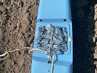
Русский: Российский разведывательный беспилотник «Картограф», приземлённый украинскими пограничниками в Харьковской области Украины.
English: Russian reconnaissance drone "Cartographer" landed by Ukrainian border guards in Kharkiv region of Ukraine.
Українська: Original description: Під час виконання бойових завдань бійці Держприкордонслужби виявили безпілотний літальний апарат, який перетнув державний кордон та летів вглиб території України. Прикордонні підрозділи на Харківщині в складі Сил оборони України разом з іншими українськими захисниками продовжують боронити Батьківщину. |
| Date | |
| Source | Прикордонники Харківщини приземлили безпілотник окупантів «Картограф» |
| Author | Ministry of Internal Affairs of Ukraine |
Licensing
[edit]_3.jpg&action=edit§ion=2)
 |
This file comes from the website, social media or Youtube channel of Ministry of Internal Affairs of Ukraine and is licensed under the Creative Commons Attribution 4.0 International License.
In short: you are free to distribute and modify the file as long as you attribute mvs.gov.ua.
|
- You are free:
- to share – to copy, distribute and transmit the work
- to remix – to adapt the work
- Under the following conditions:
- attribution – You must give appropriate credit, provide a link to the license, and indicate if changes were made. You may do so in any reasonable manner, but not in any way that suggests the licensor endorses you or your use.
File history
Click on a date/time to view the file as it appeared at that time.
| Date/Time | Thumbnail | Dimensions | User | Comment | |
|---|---|---|---|---|---|
| current | 01:07, 11 June 2023 | | 1,600 × 1,200 (330 KB) | Sneeuwschaap (talk | contribs) | Uploaded a work by Ministry of Internal Affairs of Ukraine from [https://mvs.gov.ua/uk/news/prikordonniki-xarkivshhini-prizemlili-bezpilotnik-okupantiv-kartograf Прикордонники Харківщини приземлили безпілотник окупантів «Картограф»] with UploadWizard |
You cannot overwrite this file.
File usage on Commons
There are no pages that use this file.
_3.jpg&oldid=773243144)