File:Ruta-aquiles.svg
Jump to navigation
Jump to search

Size of this PNG preview of this SVG file: 800 × 433 pixels. Other resolutions: 320 × 173 pixels | 640 × 347 pixels | 1,024 × 554 pixels | 1,280 × 693 pixels | 2,560 × 1,386 pixels | 1,230 × 666 pixels.
Original file (SVG file, nominally 1,230 × 666 pixels, file size: 120 KB)
Captions
Captions
Add a one-line explanation of what this file represents
Summary
[edit]
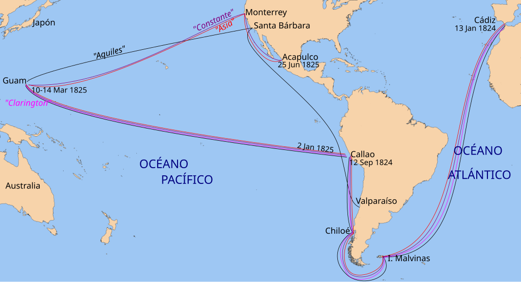
| Description | route of the Spanish ships "Asia", "Aquiles" and "Constante" 1824-1825 |
| Date | (UTC) |
| Source |
This file was derived from: Blank map of the world (Robinson projection) (90W).svg: |
| Author |
|
_(90W).svg)
| This is a retouched picture, which means that it has been digitally altered from its original version. Modifications: added die route of the ships Aquiles, Asia, Constante. The original can be viewed here: Blank map of the world (Robinson projection) (90W).svg:
|
Licensing
[edit]
I, the copyright holder of this work, hereby publish it under the following license:
| I, the copyright holder of this work, release this work into the public domain. This applies worldwide. In some countries this may not be legally possible; if so: I grant anyone the right to use this work for any purpose, without any conditions, unless such conditions are required by law. |
Original upload log
[edit]
This image is a derivative work of the following images:
- File:Blank map of the world (Robinson projection) (90W).svg licensed with PD-self
- 2012-09-15T06:19:47Z Milenioscuro 3121x1586 (2184898 Bytes) == {{int:filedesc}} == {{Information |Description=A blank map of the world centered at the 90W longitude line. Detailed SVG map with grouping enabled to connect all non-contiguous parts of a country's territory for easy col
Uploaded with derivativeFX
File history
Click on a date/time to view the file as it appeared at that time.
| Date/Time | Thumbnail | Dimensions | User | Comment | |
|---|---|---|---|---|---|
| current | 22:35, 2 November 2012 | | 1,230 × 666 (120 KB) | Keysanger (talk | contribs) | == {{int:filedesc}} == {{Information |Description=route of the Spanish ships "Asia", "Aquiles" and "Constante" 1824-1825 |Source={{Derived from|ColoredBlankMap-World-90W.svg|display=50}} |Date=2012-11-02 22:32 (UTC) |Author=*[[:File:ColoredBlankMap-Wor... |
You cannot overwrite this file.
File usage on Commons
There are no pages that use this file.
File usage on other wikis
The following other wikis use this file:
- Usage on es.wikipedia.org
- Usage on www.wikidata.org