File:Ruta Nacional 55 (Argentina).svg
Jump to navigation
Jump to search

Size of this PNG preview of this SVG file: 571 × 600 pixels. Other resolutions: 228 × 240 pixels | 457 × 480 pixels | 731 × 768 pixels | 975 × 1,024 pixels | 1,949 × 2,048 pixels | 987 × 1,037 pixels.
Original file (SVG file, nominally 987 × 1,037 pixels, file size: 52 KB)
Captions
Captions
Add a one-line explanation of what this file represents
Summary
[edit].svg&action=edit§ion=1)
| Description |
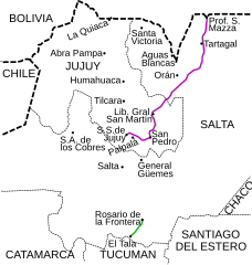
English: Map of old National Route 55. The first alignment (1935-1943) is marked in violet (currently Provincial Route 56 in Jujuy province and National Route 34). The second alignment (1943-1979) is marked in green (currently it is the Provincial Route 25 in Salta province). Español: Mapa de la antigua Ruta Nacional 55. La primera traza (1935-1943) está marcada en violeta (actualmente Ruta Provincial 56 en Jujuy y Ruta Nacional 34). La segunda traza (1943-1979) está marcada en verde (actualmente Ruta Provincial 25 en Salta). |
| Date | |
| Source | Own work |
| Author | Dario Alpern |
Licensing
[edit].svg&action=edit§ion=2)
I, the copyright holder of this work, hereby publish it under the following license:

|
Permission is granted to copy, distribute and/or modify this document under the terms of the GNU Free Documentation License, Version 1.2 or any later version published by the Free Software Foundation; with no Invariant Sections, no Front-Cover Texts, and no Back-Cover Texts. A copy of the license is included in the section entitled GNU Free Documentation License. |
| This file is licensed under the Creative Commons Attribution-Share Alike 3.0 Unported license. | ||
| ||
| This licensing tag was added to this file as part of the GFDL licensing update. |
This W3C-unspecified vector image was created with Inkscape .
File history
Click on a date/time to view the file as it appeared at that time.
| Date/Time | Thumbnail | Dimensions | User | Comment | |
|---|---|---|---|---|---|
| current | 20:35, 2 August 2008 | | 987 × 1,037 (52 KB) | Alpertron (talk | contribs) | Added first alignment (1935-1943) of National Route 55. |
| 01:39, 26 September 2007 |  | 563 × 615 (41 KB) | Alpertron (talk | contribs) | {{Information |Description=Map of old National Route 55. Currently it is the Provincial Route 25 in Salta province. |Source=self-made |Date=25 September 2007 |Author=Dario Alpern }} |
You cannot overwrite this file.
File usage on Commons
There are no pages that use this file.
File usage on other wikis
The following other wikis use this file:
- Usage on es.wikipedia.org
.svg&oldid=484997739)