File:Rzeczpospolita Rozbiory 1.png
Навигацияға күсергә
Эҙләүгә күсергә

Ҡарап сығыу ваҡытындағы күләм: 765 × 600 пиксель. Башҡа айырыусанлыҡтар: 306 × 240 пиксель | 612 × 480 пиксель | 980 × 768 пиксель | 1280 × 1004 пиксель | 2000 × 1568 пиксель.
Сығанаҡ файл (2000 × 1568 нөктә, файлдың дәүмәле: 234 КБ, MIME төрө: image/png)
Краткие подписи
Краткие подписи
Добавьте однострочное описание того, что собой представляет этот файл
Ҡыҫҡа аңлатма
[үҙгәртергә]
|
Это изображение неизвестного типа «historical map» желательно воссоздать или аккуратно преобразовать в векторный формат SVG. Это даёт несколько преимуществ, прочитать о которых подробнее вы можете на странице Commons:Media for cleanup. Если вам уже сейчас доступна векторная версия данного изображения, загрузите её, пожалуйста, а затем замените этот шаблон на следующий: {{Vector version available|Имя загруженного файла.svg}}.
|
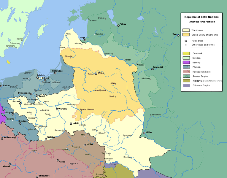
Polish-Lithuanian Commonwealth after the First Partition.
Лицензиялау
[үҙгәртергә]The following is a list of maps created by Halibutt and uploaded to commons, as well as their present and projected derivatives.
| Parent Image | Image | Description | |||||||||||
|---|---|---|---|---|---|---|---|---|---|---|---|---|---|
| Maps by Halibutt | |||||||||||||
| Image:Rzeczpospolita.png | Image:Rzeczpospolita.png | The Republic in 17th and 18th century | |||||||||||
| Image:Rzeczpospolita 1600.png | The Republic after the Treaty of Dywilino | ||||||||||||
| Image:Rzeczpospolita voivodships.png | Voivodships of The Republic | ||||||||||||
| Image:Rzeczpospolita_Potop.png | The Republic during The Deluge and Chmielnicki Uprising, with major battles of the era marked | ||||||||||||
| Magnates and their lands and domains | |||||||||||||
| 1st • 2nd • 3rd | Partitions of Poland | ||||||||||||
| War of the constitution | |||||||||||||
| Image:Rzeczpospolita.xcf | SOURCE FILE - GIMP format | ||||||||||||
| Image:Poland 1939.png | Image:Poland 1939.png | Poland in 1939 | |||||||||||
| Image:Dywizje wrzesien 1.png | Order of Battle on September 1st, during the Polish Defence War of 1939 | ||||||||||||
| Image:Poland 1939.xcf | SOURCE FILE - GIMP format | ||||||||||||
| Image:Polska kontur bialy.png | Image:Polska kontur bialy.png | Contour map of Poland AD 1999, for use with various locator maps | |||||||||||
| Image:Rzeczpospolita 1923.png | Image:Rzeczpospolita 1923.png | Map of Poland 1918-1939, currently under development | |||||||||||
| Image:PBW March 1919.png | Polish-Bolshevik War - fronts in March of 1919 | ||||||||||||
| Image:PBW December 1919.png | Polish-Bolshevik War - fronts in December of 1919 | ||||||||||||
| Image:PBW June 1920.png | Polish-Bolshevik War - fronts in July of 1920 | ||||||||||||
| Image:PBW August 1920.png | Polish-Bolshevik War - fronts in August of 1920 | ||||||||||||
| Polish Defence War of 1939 | |||||||||||||
| Polish areas annexed by Germany, Lithuania, Slovakia and the Soviet Union | |||||||||||||
| German concentration camps in Poland | |||||||||||||
| Curzon line | |||||||||||||
| Major battles of the Polish-Bolshevik War | |||||||||||||
| names • no names | Polish/Czechoslovak/Lithuanian/German/Ukrainian claims in 1920's | ||||||||||||
| Image:Rzeczpospolita Central Lithuania.png | Central Lithuania | ||||||||||||
| Image:Rzeczpospolita Lithuania claims.png | Central Lithuania as compared with other Lithuanian claims | ||||||||||||
| Image:Rzeczpospolita 1789-1920.png | Post-1922 borders compared with the territory of Poland before the partitions | ||||||||||||
| Warsaw Uprising and the Operation Tempest | |||||||||||||
| Poland partitioned between the Soviets and the Germans | |||||||||||||
| Image:Rzeczpospolita 1939 Polish divisions.png | Polish divisions on September 1, 1939 | ||||||||||||
| Home Army inspectorates | |||||||||||||
| Image:Rzeczpospolita 1922.xcf | SOURCE FILE - GIMP format | ||||||||||||
| Image:Rzeczpospolita 1937.svg | Vector version!!!! | layered version available on request | |||||||||||
Since the legal status of the above comment has been questioned, I hereby grant anyone the right to treat it as either a standard copyright notice, invariant section, legal statement, legal advice, friendly suggestion or a mere comment, depending on his or hers own choice. |
|

Файл тарихы
Файлдың күрһәтелгән ваҡытта ниндәй өлгөлә булғанын ҡарар өсөн баҫығыҙ: Дата/ваҡыт
| Дата/ваҡыт | Миниатюра | Үлсәмдәре | Ҡатнашыусы | Иҫкәрмә | |
|---|---|---|---|---|---|
| ағымдағы | 14:40, 6 май 2016 | | 2000 × 1568 (234 КБ) | Julieta39 (фекер алышыу | өлөш) | Cosmetic changes : see sources in the discussion page of today. |
| 14:44, 24 февраль 2010 |  | 2000 × 1568 (187 КБ) | Dcoetzee (фекер алышыу | өлөш) | Remove watermark, pngcrush | |
| 20:16, 16 февраль 2006 |  | 2000 × 1568 (271 КБ) | Tomekpe (фекер алышыу | өлөш) | Corrected mistakes from discussion. * Silesia at the time belonged to Prussia, whereas the map shows it belonging to Austria. * Sweden no longer had Estonia. * Denmark no longer had the island off the coast of Estonia. * The Ottoman Empire did not contro | |
| 21:38, 25 декабрь 2005 |  | 2000 × 1568 (273 КБ) | Tomekpe (фекер алышыу | өлөш) | Halibutt's graphic with marked polish-russian border. | |
| 13:40, 10 ғинуар 2005 |  | 2000 × 1568 (269 КБ) | Halibutt (фекер алышыу | өлөш) | Polish-Lithuanian Commonwealth after the 1st Partition<br>{{User:Halibutt/maps}}<br>{{User:Halibutt/GFDL}}<br>Category:Maps of Poland<br>Category:Historical maps |
Һеҙ был файлды ҡабаттан яҙҙыра алмайһығыҙ.
Файл ҡулланыу
Был файлды киләһе 4 биттәр ҡуллана:
Файлды глобаль ҡулланыу
Был файл түбәндәге википроекттарҙа ҡулланыла:
- af.wikipedia.org проектында ҡулланыу
- ar.wikipedia.org проектында ҡулланыу
- ast.wikipedia.org проектында ҡулланыу
- azb.wikipedia.org проектында ҡулланыу
- be-tarask.wikipedia.org проектында ҡулланыу
- be.wikipedia.org проектында ҡулланыу
- bg.wikipedia.org проектында ҡулланыу
- br.wikipedia.org проектында ҡулланыу
- ca.wikipedia.org проектында ҡулланыу
- cs.wikipedia.org проектында ҡулланыу
- en.wikipedia.org проектында ҡулланыу
- es.wikipedia.org проектында ҡулланыу
- et.wikipedia.org проектында ҡулланыу
- fi.wikipedia.org проектында ҡулланыу
- fr.wikipedia.org проектында ҡулланыу
- gl.wikipedia.org проектында ҡулланыу
- he.wikipedia.org проектында ҡулланыу
- hr.wikipedia.org проектында ҡулланыу
- hu.wikipedia.org проектында ҡулланыу
- id.wikipedia.org проектында ҡулланыу
- it.wikipedia.org проектында ҡулланыу
- ja.wikipedia.org проектында ҡулланыу
- ka.wikipedia.org проектында ҡулланыу
- ko.wikipedia.org проектында ҡулланыу
Был файлды глобаль ҡулланыуҙы ҡарарға.