File:SEA-ME-WE-4-Route.png
Jump to navigation
Jump to search

Size of this preview: 800 × 441 pixels. Other resolutions: 320 × 176 pixels | 640 × 353 pixels | 1,024 × 564 pixels | 1,280 × 705 pixels | 3,006 × 1,656 pixels.
Original file (3,006 × 1,656 pixels, file size: 773 KB, MIME type: image/png)
Captions
Captions
Add a one-line explanation of what this file represents
Summary
[edit]| Description |
|
|||
| Date | 22 February 2007 (upload date) | |||
| Source | Own work, Data from the official website. | |||
| Author | J.P.Lon | |||
| Other versions |
|


-- Note: As of 2007, the map was (all but) correct, with regards to borders
 (except for an error in the German border), but due to rearrangements since,
 there may be differences to current (and future...) borders.  - J.P.Lon (talk) 20:08, 19 April 2009 (UTC)
Licensing
[edit]
I, the copyright holder of this work, hereby publish it under the following licenses:

|
Permission is granted to copy, distribute and/or modify this document under the terms of the GNU Free Documentation License, Version 1.2 or any later version published by the Free Software Foundation; with no Invariant Sections, no Front-Cover Texts, and no Back-Cover Texts. A copy of the license is included in the section entitled GNU Free Documentation License. |
| This file is licensed under the Creative Commons Attribution-Share Alike 3.0 Unported license. | ||
| ||
| This licensing tag was added to this file as part of the GFDL licensing update. |
This file is licensed under the Creative Commons Attribution 2.5 Generic license.
- You are free:
- to share – to copy, distribute and transmit the work
- to remix – to adapt the work
- Under the following conditions:
- attribution – You must give appropriate credit, provide a link to the license, and indicate if changes were made. You may do so in any reasonable manner, but not in any way that suggests the licensor endorses you or your use.
You may select the license of your choice.
File history
Click on a date/time to view the file as it appeared at that time.
| Date/Time | Thumbnail | Dimensions | User | Comment | |
|---|---|---|---|---|---|
| current | 20:31, 7 January 2014 | | 3,006 × 1,656 (773 KB) | Nameless23 (talk | contribs) | Removed inner German border |
| 12:05, 3 March 2007 |  | 3,006 × 1,656 (647 KB) | Helix84 (talk | contribs) | optimized with optipng | |
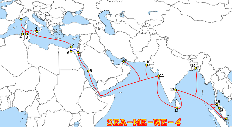
| 20:16, 22 February 2007 |  | 3,006 × 1,656 (935 KB) | J.P.Lon~commonswiki (talk | contribs) | The route of the SEA-ME-WE-4 Telecoms Cable. The majority of it is submarine(shown in Red), in Egypt a segment is terrestrial(Blue). For more information regarding this and locations of the landing points (Numbered above), |
You cannot overwrite this file.
File usage on Commons
The following page uses this file:
File usage on other wikis
The following other wikis use this file:
- Usage on ar.wikipedia.org
- Usage on bn.wikipedia.org
- Usage on en.wikipedia.org
- Usage on en.wikinews.org
- Usage on es.wikipedia.org
- Usage on fr.wikipedia.org
- Usage on it.wikipedia.org
- Usage on nl.wikipedia.org
- Usage on pl.wikipedia.org
- Usage on si.wikipedia.org
- Usage on vi.wikipedia.org
- Usage on www.wikidata.org
- Usage on zh.wikipedia.org