File:SO2.jpg
跳至導覽
跳至搜尋
預覽大小:800 × 594 像素。 其他解析度:320 × 237 像素 | 640 × 475 像素 | 1,024 × 760 像素 | 1,078 × 800 像素。
原始檔案 (1,078 × 800 像素,檔案大小:188 KB,MIME 類型:image/jpeg)
說明
說明
添加單行說明來描述出檔案所代表的內容
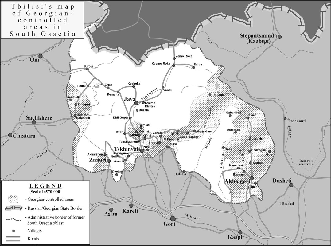
| 描述 | South Ossetia detailed map (zones of control according to the Georgian governmnet) |
| 日期 | |
| 來源 | International Crisis Group: [1] |
| 作者 | |
| 授權許可 (重用此檔案) |
PD ("Unless otherwise specifically stated, no claim to copyright is being asserted by Crisis Group and material on this website may be freely used as in the public domain.") |
| 其他版本 | en:Image:SouthOssetia region detailed map.JPG |
| 此作品已由其作者,International Crisis Group,釋出至公有領域。此授權條款在全世界均適用。 這可能在某些國家不合法,如果是的話: International Crisis Group授予任何人有權利使用此作品於任何用途,除受法律約束外,不受任何限制。
|
檔案歷史
點選日期/時間以檢視該時間的檔案版本。
| 日期/時間 | 縮圖 | 尺寸 | 使用者 | 備註 | |
|---|---|---|---|---|---|
| 目前 | 2007年7月10日 (二) 09:26 | | 1,078 × 800(188 KB) | Alaexis(留言 | 貢獻) | {{Information |Description=South Ossetia detailed map (zones of control according to the Georgian governmnet) |Source=International Crisis Group: [http://www.crisisgroup.org/home/index.cfm?id=4887&l=3] |Date=june 2007 |Permission= PD ([http://www.cris |
無法覆蓋此檔案。
檔案用途
下列頁面有用到此檔案:
全域檔案使用狀況
以下其他 wiki 使用了這個檔案:
- de.wikipedia.org 的使用狀況
- el.wikipedia.org 的使用狀況
- en.wikipedia.org 的使用狀況
- hu.wikipedia.org 的使用狀況
- ja.wikipedia.org 的使用狀況
- ka.wikipedia.org 的使用狀況
- ru.wikipedia.org 的使用狀況
- sk.wikipedia.org 的使用狀況
- ta.wikipedia.org 的使用狀況
- uk.wikipedia.org 的使用狀況
- xmf.wikipedia.org 的使用狀況
- zh.wikipedia.org 的使用狀況