File:SRTM-W72.00E69.70S34.00N33.00.Talagante.png
Jump to navigation
Jump to search

Size of this preview: 800 × 429 pixels. Other resolutions: 320 × 172 pixels | 640 × 343 pixels | 1,024 × 549 pixels | 1,280 × 686 pixels | 1,915 × 1,027 pixels.
Original file (1,915 × 1,027 pixels, file size: 2.6 MB, MIME type: image/png)
Captions
Captions
Add a one-line explanation of what this file represents
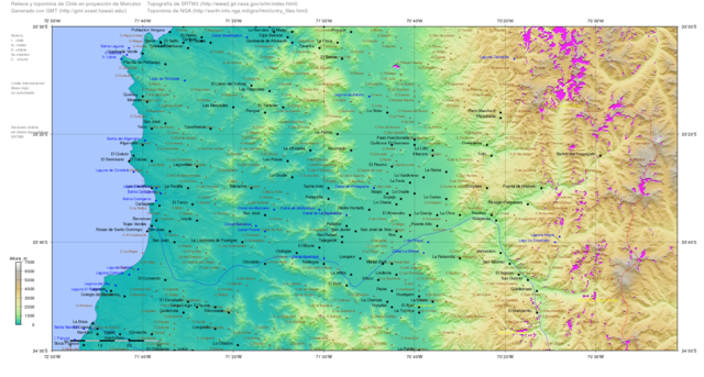
| Description | Map of Chile generated with GMT (http://gmt.soest.hawaii.edu/), topography from SRTM ftp://e0srp01u.ecs.nasa.gov/srtm/version2/SRTM3/ and toponymy from http://earth-info.nga.mil/gns/html/cntry_files.html | ||||||||||
| Date | |||||||||||
| Source | self-compiled | ||||||||||
| Author | RAVL | ||||||||||
| Permission (Reusing this file) |
|

File history
Click on a date/time to view the file as it appeared at that time.
| Date/Time | Thumbnail | Dimensions | User | Comment | |
|---|---|---|---|---|---|
| current | 14:17, 16 January 2008 | | 1,915 × 1,027 (2.6 MB) | Keysanger (talk | contribs) | {{Information |Description=Map of Chile generated with GMT (http://gmt.soest.hawaii.edu/), topography from SRTM ftp://e0srp01u.ecs.nasa.gov/srtm/version2/SRTM3/ and toponymy from http://earth-info.nga.mil/gns/html/cntry_files.html |Source=self-compiled |D |
You cannot overwrite this file.
File usage on Commons
There are no pages that use this file.
File usage on other wikis
The following other wikis use this file:
- Usage on en.wikipedia.org
- Usage on hy.wikipedia.org