File:Sable island.jpg
跳至導覽
跳至搜尋

預覽大小:598 × 600 像素。 其他解析度:239 × 240 像素 | 637 × 639 像素。
原始檔案 (637 × 639 像素,檔案大小:103 KB,MIME 類型:image/jpeg)
說明
說明
添加單行說明來描述出檔案所代表的內容
摘要
[編輯]
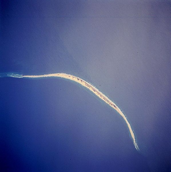
| 描述 | Satellite image of Sable Island (Canada). STS059-216-079 Sable Island, Nova Scotia, Canada April 1994 Sable Island is a low sandy island approximately 25 miles (40 km) long and 1 mile (1.5 km) wide in the Atlantic Ocean. Located 115 miles (180 km) southeast of Cape Canso, Nova Scotia, the island is the exposed part of a sand shoal that extends northeast/southwest for more than 100 miles (160 km). Sable Island, known as the “graveyard of the Atlantic Ocean,” has been a major hazard to navigation. The island is also noted as a breeding ground for seals, which are protected by the Canadian government. The island helps to mark the western edge of the northeasterly flowing warm waters of the Gulf Stream. |
| 日期 | |
| 來源 | eol.jsc.nasa.gov |
| 作者 | NASA |
| 其他版本 | Derivative works of this file: Sable island-N.png |
本圖像或影音收錄於美國國家航空暨太空總署 (NASA)某部門,其照片編號為: STS059-216-079 此標籤不表示文件的著作權狀態。任何文件在附有此標籤的同時還需要一個有效的著作權標籤。請參閱許可協議說明頁面以了解更多資訊。 其他語言:
|
授權條款
[編輯]
| 本作品由NASA創作,屬於公有領域。根據NASA的版權政策:“NASA的創作除非另有聲明否則不受版權保護。”(參見:Template:PD-USGov/zh,NASA版權政策或JPL圖像使用政策) | ||
 |
警告:
|
檔案歷史
點選日期/時間以檢視該時間的檔案版本。
| 日期/時間 | 縮圖 | 尺寸 | 用戶 | 備註 | |
|---|---|---|---|---|---|
| 目前 | 2005年12月2日 (五) 17:44 | | 637 × 639(103 KB) | Islandspec~commonswiki(對話 | 貢獻) | Satellite image of Sable Island (Canada). Source:English Wikipedia. |
無法覆蓋此檔案。
檔案用途
全域檔案使用狀況
以下其他 wiki 使用了這個檔案:
- ar.wikipedia.org 的使用狀況
- arz.wikipedia.org 的使用狀況
- bg.wikipedia.org 的使用狀況
- ceb.wikipedia.org 的使用狀況
- de.wikipedia.org 的使用狀況
- de.wikivoyage.org 的使用狀況
- el.wikipedia.org 的使用狀況
- en.wikipedia.org 的使用狀況
- en.wikivoyage.org 的使用狀況
- eo.wikipedia.org 的使用狀況
- es.wikipedia.org 的使用狀況
- fr.wikivoyage.org 的使用狀況
- fy.wikipedia.org 的使用狀況
- he.wikipedia.org 的使用狀況
- is.wikipedia.org 的使用狀況
- it.wikipedia.org 的使用狀況
- ja.wikipedia.org 的使用狀況
- ko.wikipedia.org 的使用狀況
- nl.wikipedia.org 的使用狀況
- no.wikipedia.org 的使用狀況
- pt.wikipedia.org 的使用狀況
- ru.wikipedia.org 的使用狀況
- sv.wikipedia.org 的使用狀況
- uk.wikipedia.org 的使用狀況
- ur.wikipedia.org 的使用狀況
- www.wikidata.org 的使用狀況
- zh.wikipedia.org 的使用狀況