File:Sachsenring.svg
Jump to navigation
Jump to search

Size of this PNG preview of this SVG file: 800 × 405 pixels. Other resolutions: 320 × 162 pixels | 640 × 324 pixels | 1,024 × 518 pixels | 1,280 × 648 pixels | 2,560 × 1,296 pixels | 1,462 × 740 pixels.
Original file (SVG file, nominally 1,462 × 740 pixels, file size: 51 KB)
Captions
Captions
Add a one-line explanation of what this file represents
Summary[edit]
| Description |
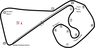
English: Track map of Sachsenring. No pit area for the "Omega Circuit" (the right half of the image) was found. |
| SVG development | |
| Date | 8-6-2008 |
| Source | openstreetmap.org |
| Creator |
OpenStreetMap contributors |
| Permission (Reusing this file) |
OpenStreetMap data and maps are licensed under the Creative Commons Attribution-ShareAlike 2.0 license (CC-BY-SA 2.0). This file is licensed under the Creative Commons Attribution-Share Alike 2.0 Generic license.
|
| Georeferencing | If inappropriate please set warp_status = skip to hide. |
| Other versions |
|


| Camera location | | View this and other nearby images on: OpenStreetMap |
|---|
File history
Click on a date/time to view the file as it appeared at that time.
| Date/Time | Thumbnail | Dimensions | User | Comment | |
|---|---|---|---|---|---|
| current | 13:09, 11 June 2021 | | 1,462 × 740 (51 KB) | Gpmat (talk | contribs) | slight fixes to Omega and pit entry; turn numbers per MotoGP.com and sachsenring.de |
| 21:36, 14 October 2014 |  | 1,460 × 727 (66 KB) | Dereckson (talk | contribs) | Reverted to version as of 09:45, 6 August 2008 | |
| 16:44, 8 October 2014 |  | 2,250 × 2,250 (137 KB) | Gustavo Girardelli (talk | contribs) | Nueva versión basada en áreas. | |
| 09:45, 6 August 2008 |  | 1,460 × 727 (66 KB) | Will Pittenger (talk | contribs) | Old version had a text object on a path that MediaWiki/RSVG currently likes to ignore. This version gets around that issue by turning that object into a path. If you need to edit the file, please use the previous version. Then upload a version with the | |
| 09:42, 6 August 2008 |  | 1,460 × 727 (46 KB) | Will Pittenger (talk | contribs) | New version fixes clipping issue | |
| 09:39, 6 August 2008 |  | 1,424 × 767 (46 KB) | Will Pittenger (talk | contribs) | {{Information |Description={{en|1=Track map of w:Sachsenring. No pit area for the "Omega Circuit" (the right half of the image) was found. All turn numbers were assigned by the image author as no such information was available.}} |Source=Own work b |
You cannot overwrite this file.
File usage on Commons
The following 9 pages use this file:
- User:Chumwa/OgreBot/Transport Maps/2021 June 11-20
- User:Chumwa/OgreBot/Travel and communication maps/2021 June 11-20
- File:Liesel 04-2011 Streckenkarte Sachsenring.png
- File:Sachsenring.jpg
- File:Sachsenring.png
- File:Sachsenring.svg
- File:Sachsenring1.png
- Category:2012 German motorcycle Grand Prix
- Category:Sachsenring
File usage on other wikis
The following other wikis use this file:
- Usage on ar.wikipedia.org
- Usage on arz.wikipedia.org
- Usage on ca.wikipedia.org
- Usage on de.wikinews.org
- Usage on en.wikipedia.org
- Sachsenring
- German motorcycle Grand Prix
- List of Grand Prix motorcycle circuits
- 2015 German motorcycle Grand Prix
- 2016 German motorcycle Grand Prix
- 2017 German motorcycle Grand Prix
- 2018 German motorcycle Grand Prix
- 2019 German motorcycle Grand Prix
- 2021 German motorcycle Grand Prix
- 2022 German motorcycle Grand Prix
- 2023 German motorcycle Grand Prix
- Usage on fr.wikipedia.org
- Grand Prix moto d'Allemagne 2006
- Grand Prix moto d'Allemagne
- Sachsenring
- Grand Prix moto d'Allemagne 2008
- Grand Prix moto d'Allemagne 2007
- Grand Prix moto d'Allemagne 2005
- Grand Prix moto d'Allemagne 2004
- Grand Prix moto d'Allemagne 2003
- Grand Prix moto d'Allemagne 2009
- Grand Prix moto d'Allemagne 2000
- Grand Prix moto d'Allemagne 2010
- Grand Prix moto d'Allemagne 2011
- Grand Prix moto d'Allemagne 2012
- Grand Prix moto d'Allemagne 2013
- Grand Prix moto d'Allemagne 2014
- Grand Prix moto d'Allemagne 2015
- Grand Prix moto d'Allemagne 2016
- Grand Prix moto d'Allemagne 2017
- Grand Prix moto d'Allemagne 2018
- Grand Prix moto d'Allemagne 2019
- Grand Prix moto d'Allemagne 2021
- Grand Prix moto d'Allemagne 2022
- Grand Prix moto d'Allemagne 2023
- Usage on hu.wikipedia.org
View more global usage of this file.