File:SafsafOasis SAR comparison.jpg
পরিভ্রমণে চলুন
অনুসন্ধানে চলুন
এর চেয়ে বেশি রেজোলিউশন লভ্য নয়।
SafsafOasis_SAR_comparison.jpg (৫৪০ × ৫৮৮ পিক্সেল, ফাইলের আকার: ১৫৪ কিলোবাইট, এমআইএমই ধরন: image/jpeg)
ক্যাপশনসমূহ
ক্যাপশন
এই ফাইল কি প্রতিনিধিত্ব করছে তার এক লাইন ব্যাখ্যা যোগ করুন
সারাংশ[সম্পাদনা]
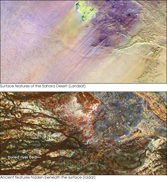
| বিবরণ | Two images of the Safsaf Oasis in The Sahara. The top image (taken by the Landat Thematic Mapper) is the surface. The bottom (taken by the Spaceborne Imaging Radar-C/X-band Synthetic Aperture Radar (SIR-C/X-SAR) on board the Space Shuttle Endeavour on April 16, 1994) is the rock layer underneath, revealing black channels cut by the meandering of an ancient river. |
| তারিখ | not specified |
| উৎস | http://earthobservatory.nasa.gov/Newsroom/NewImages/images.php3?img_id=16963 |
| লেখক | NASA/JPL Imaging Radar team. |
| অনুমতি (এ ফাইলের পুনঃব্যবহার) |
Public domain |
| অন্যান্য সংস্করণ |
|


লাইসেন্স প্রদান[সম্পাদনা]
| এই ফাইলটি পাবলিক ডোমেইনে আছে কারণ এটি শুধুমাত্র নাসা কর্তৃক নির্মিত হয়েছিল। নাসার কপিরাইট নীতি হচ্ছে যে "নাসা কর্তৃক উল্লেখ না থাকলে নাসার উপাদান কপিরাইট দ্বারা সুরক্ষিত নয়"। (Template:PD-USGov, নাসার কপিরাইট নীতির পাতা অথবা জেপিএল চিত্র ব্যবহারের নীতি দেখুন।) | ||
 |
সতর্কবার্তা:
|
ফাইলের ইতিহাস
যেকোনো তারিখ/সময়ে ক্লিক করে দেখুন ফাইলটি তখন কী অবস্থায় ছিল।
| তারিখ/সময় | সংক্ষেপচিত্র | মাত্রা | ব্যবহারকারী | মন্তব্য | |
|---|---|---|---|---|---|
| বর্তমান | ১৫:৫৫, ৯ মে ২০০৬ | | ৫৪০ × ৫৮৮ (১৫৪ কিলোবাইট) | Holly Cheng (আলোচনা | অবদান) | {{Information | Description=Two images of the Safsaf Oasis in the Sahara. The top image (taken by the Landat Thematic Mapper) is the surface. The bottom (taken by the Spaceborne Imaging Radar-C/X-band Synthetic Aperture Radar (SIR-C/X-SAR) on board the Sp |
আপনি এই ফাইলটি প্রতিস্থাপন করতে পারবেন না।
ফাইলের ব্যবহার
নিম্নলিখিত 4টি পাতা এই ফাইল ব্যবহার করে:
ফাইলের বৈশ্বিক ব্যবহার
নিচের অন্যান্য উইকিগুলো এই ফাইলটি ব্যবহার করে:
- es.wikipedia.org-এ ব্যবহার
- eu.wikipedia.org-এ ব্যবহার
- la.wikipedia.org-এ ব্যবহার
- nds-nl.wikipedia.org-এ ব্যবহার
- rw.wikipedia.org-এ ব্যবহার
- sw.wikipedia.org-এ ব্যবহার
- vi.wikipedia.org-এ ব্যবহার
- zh-yue.wikipedia.org-এ ব্যবহার