File:Saint-Martin Island map-en.svg
ナビゲーションに移動
検索に移動

この SVG ファイルのこの PNG プレビューのサイズ: 796 × 600 ピクセル. その他の解像度: 319 × 240 ピクセル | 637 × 480 ピクセル | 1,020 × 768 ピクセル | 1,280 × 964 ピクセル | 2,560 × 1,928 ピクセル | 1,102 × 830 ピクセル。
元のファイル (SVG ファイル、1,102 × 830 ピクセル、ファイルサイズ: 866キロバイト)
キャプション
キャプション
このファイルの内容を1行で記述してください
概要
[編集]| カメラの位置 | | 以下のサービスでこの位置を確認する: オープンストリートマップ |
|---|
| 解説 |
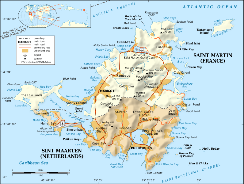
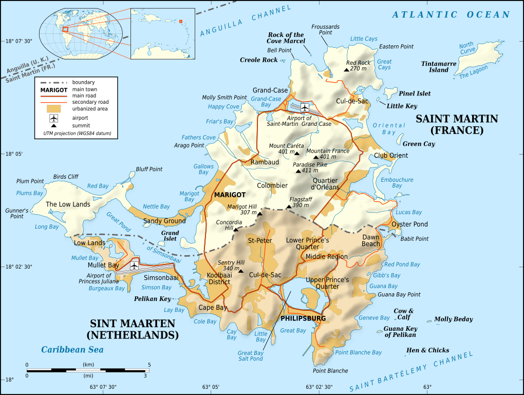
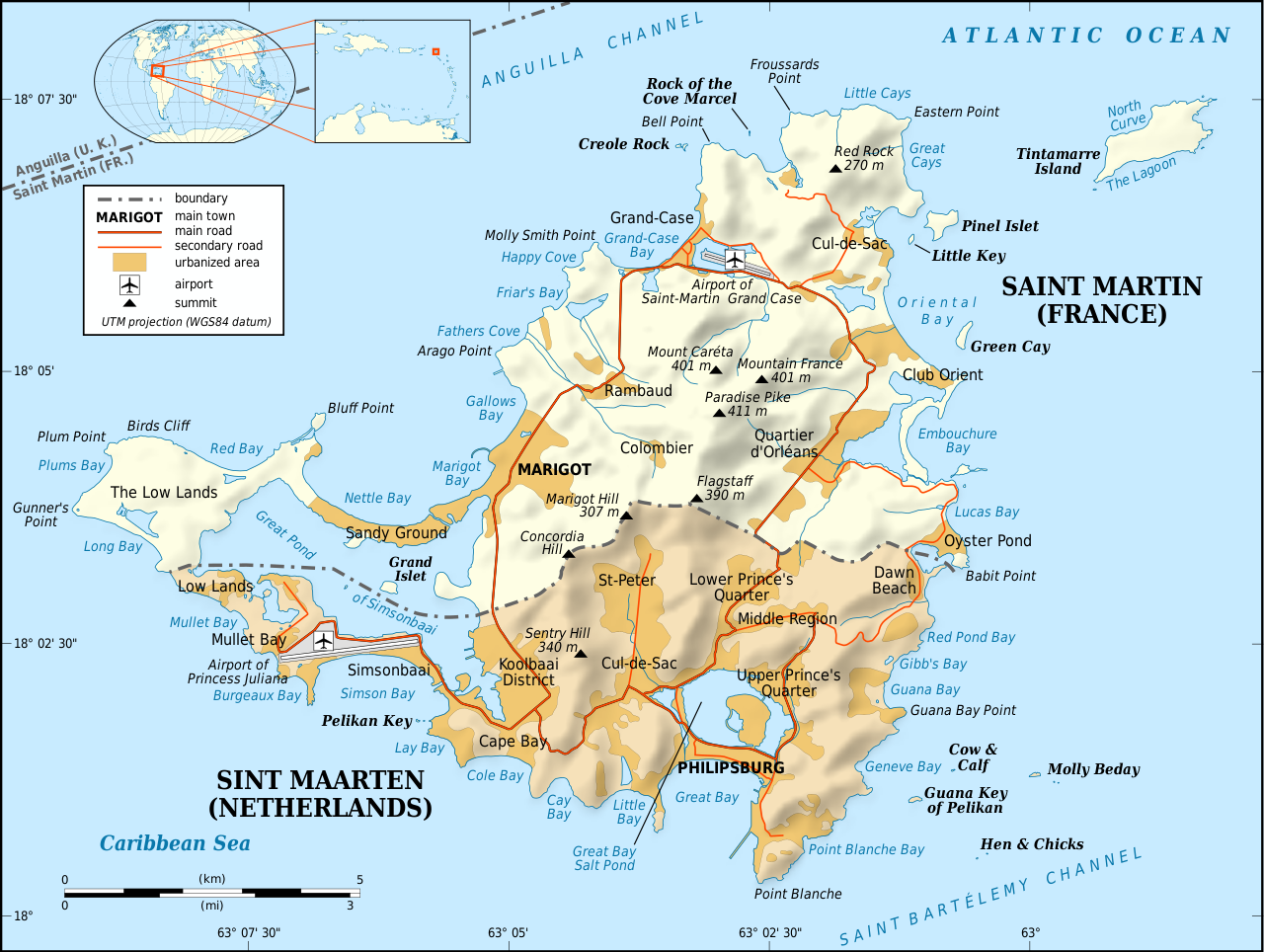
English: Map in English of the Caribbean island of Saint-Martin / Sint Maarten, divided between French and Dutch halves.
Note: the shaded relief is a raster image embedded in the SVG file. Français : Carte en anglais de l'île de Saint-Martin / Sint Maarten dans les Antilles, divisée en une partie française et une partie néerlandaise. Note : les ombres du relief sont une image bitmap embarquée dans le fichier SVG.
|
||
| 日付 | January 2009 (translation in May 2009) | ||
| 原典 |
Own work
|
||
| 作者 | Eric Gaba (Sting - fr:Sting) | ||
| 許可 (ファイルの再利用) |
|
||
| その他のバージョン |
[]
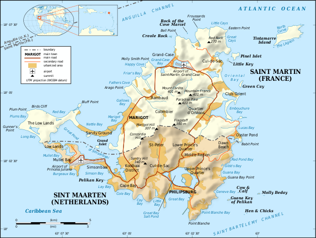
Same base map but smaller and without topography:
|


|
このSVGファイルには翻訳可能な埋め込みテキストが含まれています。SVG翻訳ツールや他のSVGエディタを使用して自分の言語に翻訳可能です。詳しくはSVGファイルの翻訳についてを参照してください。 |
ライセンス
[編集]
この作品の著作権者である私は、この作品を以下のライセンスで提供します。
このファイルはクリエイティブ・コモンズ 表示-継承 3.0 非移植ライセンスのもとに利用を許諾されています。
- あなたは以下の条件に従う場合に限り、自由に
- 共有 – 本作品を複製、頒布、展示、実演できます。
- 再構成 – 二次的著作物を作成できます。
- あなたの従うべき条件は以下の通りです。
- 表示 – あなたは適切なクレジットを表示し、ライセンスへのリンクを提供し、変更があったらその旨を示さなければなりません。これらは合理的であればどのような方法で行っても構いませんが、許諾者があなたやあなたの利用行為を支持していると示唆するような方法は除きます。
- 継承 – もしあなたがこの作品をリミックスしたり、改変したり、加工した場合には、あなたはあなたの貢献部分を元の作品とこれと同一または互換性があるライセンスの下に頒布しなければなりません。

|
この文書は、フリーソフトウェア財団発行のGNUフリー文書利用許諾書 (GNU Free Documentation License) 1.2またはそれ以降のバージョンの規約に基づき、複製や再配布、改変が許可されます。不可変更部分、表紙、背表紙はありません。このライセンスの複製は、GNUフリー文書利用許諾書という章に含まれています。 |
あなたは上記のライセンスから、どれか一つ以上を選択できます。
ファイルの履歴
過去の版のファイルを表示するには、その版の日時をクリックしてください。
| 日付と時刻 | サムネイル | 寸法 | 利用者 | コメント | |
|---|---|---|---|---|---|
| 現在の版 | 2009年5月5日 (火) 20:34 | | 1,102 × 830 (866キロバイト) | Sting (トーク | 投稿記録) | Spelling error correction |
| 2009年5月5日 (火) 19:13 |  | 1,102 × 830 (865キロバイト) | Sting (トーク | 投稿記録) | {{Location|18|04|00|N|63|03|30|W|scale:100000}} <br/> {{Information |Description={{en|Map in English of the Caribbean island of Saint-Martin / Sint Maarten, divided between French and Dutch halves.<br/> ''Note: the shaded relief is a |
このファイルは上書きできません。
ファイルの使用状況
以下の 8 ページがこのファイルを使用しています:
- Saint-Martin (France)
- File:Saint-Martin Island map-be.svg
- File:Saint-Martin Island map-en.svg
- File:Saint-Martin Island map-fr.svg
- File:Saint-Martin Island topographic map-en.svg
- File:Saint-Martin Island topographic map-fr.svg
- File:Saint-Martin Island topographic map-mk.svg
- Template:Other versions/Saint-Martin Island topographic map
グローバルなファイル使用状況
以下に挙げる他のウィキがこの画像を使っています:
- azb.wikipedia.org での使用状況
- bs.wikipedia.org での使用状況
- cs.wikipedia.org での使用状況
- en.wikipedia.org での使用状況
- en.wikibooks.org での使用状況
- es.wikipedia.org での使用状況
- fa.wikipedia.org での使用状況
- it.wikipedia.org での使用状況
- ja.wikipedia.org での使用状況
- sr.wikipedia.org での使用状況
- zh.wikipedia.org での使用状況