File:Saint-Nazaire--village.jpg
Jump to navigation
Jump to search

Size of this preview: 800 × 462 pixels. Other resolutions: 320 × 185 pixels | 640 × 370 pixels | 1,024 × 592 pixels | 1,280 × 739 pixels | 3,422 × 1,977 pixels.
Original file (3,422 × 1,977 pixels, file size: 772 KB, MIME type: image/jpeg)
Captions
Captions
Add a one-line explanation of what this file represents
Summary[edit]
| Description |
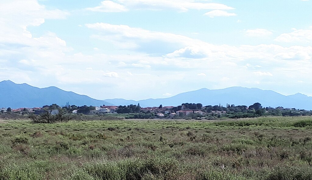
Français : Le village est situé sur une butte qui s'élève à près de 20 mètres au-dessus de la plaine environnante, elle-même presque au niveau de la mer. La butte repose sur un affleurement isolé de dépôts continentaux du Pliocène (principalement des sables et des graviers), déposés par des rivières il y a environ 4 millions d'années. La plaine environnante est couverte de dépôts plus récents du Pléistocène supérieur et de l'Holocène, y compris des dépôts lagunaires (boues et limons) au premier plan.
A l'arrière-plan, les massifs des Albères et du Vallespir (formations paléozoïques), le long desquelles s'étend la frontière entre la France et l'Espagne. Voir : Clauzon, G. et al, "Notice explicative de la feuille Perpignan (1091) à 1/50 000", BRGM Éditions, Orléans, 1989 ; pages 10-14, sur http://ficheinfoterre.brgm.fr/Notices/1091N.pdf.English: The village sits on a hillock which rises nearly 20 metres above the surronding plain, itself almost at sea level. The hillock is underlain by an isolated outcrop of continental Pliocene deposits (mainly sands and gravels), which were laid down by rivers around 4 million years ago.
The surrounding plain is covered by more recent upper Pleistocene and Holocene deposits, including lagoon deposits (muds and silts) in the foreground. In the background are hills of the Albères and Vallespir ranges (Palaeozoic formations), along which runs the frontier between France and Spain. See: Clauzon, G. et al., "Notice explicative de la feuille Perpignan (1091) à 1/50 000", BRGM Éditions, Orléans, 1989; pages 10-14, at http://ficheinfoterre.brgm.fr/Notices/1091N.pdf. |
| Date | |
| Source | Own work |
| Author | Alan Mattingly |
| Camera location | | View this and other nearby images on: OpenStreetMap |
|---|
Licensing[edit]
I, the copyright holder of this work, hereby publish it under the following license:
This file is licensed under the Creative Commons Attribution-Share Alike 4.0 International license.
- You are free:
- to share – to copy, distribute and transmit the work
- to remix – to adapt the work
- Under the following conditions:
- attribution – You must give appropriate credit, provide a link to the license, and indicate if changes were made. You may do so in any reasonable manner, but not in any way that suggests the licensor endorses you or your use.
- share alike – If you remix, transform, or build upon the material, you must distribute your contributions under the same or compatible license as the original.
File history
Click on a date/time to view the file as it appeared at that time.
| Date/Time | Thumbnail | Dimensions | User | Comment | |
|---|---|---|---|---|---|
| current | 13:49, 24 June 2023 | | 3,422 × 1,977 (772 KB) | Alan Mattingly (talk | contribs) | Uploaded own work with UploadWizard |
You cannot overwrite this file.
File usage on Commons
There are no pages that use this file.
File usage on other wikis
The following other wikis use this file:
- Usage on fr.wikipedia.org