File:SaintPierre1780.png
ナビゲーションに移動
検索に移動

このプレビューのサイズ: 800 × 464 ピクセル。 その他の解像度: 320 × 186 ピクセル | 640 × 371 ピクセル | 869 × 504 ピクセル。
元のファイル (869 × 504 ピクセル、ファイルサイズ: 828キロバイト、MIME タイプ: image/png)
キャプション
キャプション
このファイルの内容を1行で記述してください
概要
[編集]| 解説 |
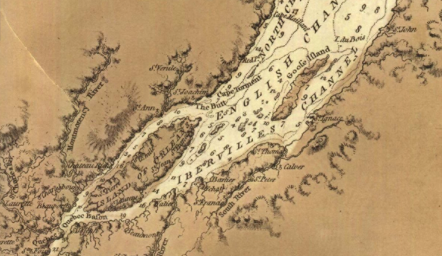
English: This is a detail from the source map, showing locations important in the March 1776 Battle of Saint-Pierre. The source map is captioned as follows: General chart of Gulph and River St. Lawrence |
|||
| 日付 | ||||
| 原典 |
URL at time of upload: http://services.banq.qc.ca/sdx/cep/document.xsp?app=ca.BAnQ.sdx.cep&db=notice&id=0002663541&n=13&sortfield=date_publication&col=america&v=saint-laurent_(fleuve)%23%23%23Saint-Laurent+(Fleuve)&order=ascendant&f=lieu_nav&chpp=20&dbrqp=query_notice&qid=sdx_q3 |
|||
| 作者 | Des Barres, Joseph F.W, (Joseph Frederick Wallet), 1722- 1824 |

ライセンス
[編集]
|
この著作物は、著作権の保護期間が著作者の死後100年以下である国・地域においてパブリックドメインの状態にあります。 | |
| このファイルは著作権法の既知の制約(隣接権や関連する権利を含む)から自由であると特定されています。 | |
ファイルの履歴
過去の版のファイルを表示するには、その版の日時をクリックしてください。
| 日付と時刻 | サムネイル | 寸法 | 利用者 | コメント | |
|---|---|---|---|---|---|
| 現在の版 | 2009年2月13日 (金) 02:12 | | 869 × 504 (828キロバイト) | Magicpiano (トーク | 投稿記録) | {{Information |Description={{en|1=This is a detail from the source map, showing locations important in the March 1776 Battle of Saint-Pierre. The source map is captioned as follows: General chart of Gulph and River St. Lawren |
このファイルは上書きできません。
ファイルの使用状況
このファイルを使用しているページはありません。
グローバルなファイル使用状況
以下に挙げる他のウィキがこの画像を使っています:
- en.wikipedia.org での使用状況
- fr.wikipedia.org での使用状況
- it.wikipedia.org での使用状況
- ja.wikipedia.org での使用状況
- nl.wikipedia.org での使用状況
- www.wikidata.org での使用状況
- zh.wikipedia.org での使用状況