File:Saint Pauls Cathedral as seen from Paternoster Row - geograph.org.uk - 77268.jpg
Ir a la navegación
Ir a la búsqueda
Tamaño de esta previsualización: 450 × 600 píxeles. Otras resoluciones: 180 × 240 píxeles | 480 × 640 píxeles.
Archivo original (480 × 640 píxeles; tamaño de archivo: 116 kB; tipo MIME: image/jpeg)
Leyendas
Leyendas
Añade una explicación corta acerca de lo que representa este archivo
Resumen
[editar]
| Descripción |
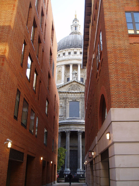
English: Saint Pauls Cathedral as seen from Paternoster Row. Paternoster Row disappeared in the post-war rebuilding of the area around Saint Paul's. It was lost under the big, ugly office blocks that blighted the area surrounding the cathedral for decades. Restored during the rebuilding of Paternoster Square, it offers one of the best views of Saint Paul's. The street gets its name from the monks of the medieval St Paul's who would walk down this passageway chanting the Lord's Prayer. |
| Fecha | |
| Fuente | From geograph.org.uk |
| Autor | David Bradbury |
| Atribución (requerido por la licencia) | David Bradbury / Saint Pauls Cathedral as seen from Paternoster Row / |
| Ubicación del objeto | | Ubicación de esta y otras imágenes en: OpenStreetMap |
|---|
_&language=es)
Licencia
[editar]

|
Esta imagen proviene de la colección del proyecto Geograph British Isles. Veáse la página de esta fotografía en el sitio web de Geograph para más información del fotógrafo. El titular de los derechos de autor de esta imagen es David Bradbury y autoriza utilizarla bajo la licencia Reconocimiento-CompartirIgual 2.0 de Creative Commons.
|
Este archivo se encuentra bajo la licencia Creative Commons Genérica de Atribución/Compartir-Igual 2.0.
Atribución: David Bradbury
- Eres libre:
- de compartir – de copiar, distribuir y transmitir el trabajo
- de remezclar – de adaptar el trabajo
- Bajo las siguientes condiciones:
- atribución – Debes otorgar el crédito correspondiente, proporcionar un enlace a la licencia e indicar si realizaste algún cambio. Puedes hacerlo de cualquier manera razonable pero no de manera que sugiera que el licenciante te respalda a ti o al uso que hagas del trabajo.
- compartir igual – En caso de mezclar, transformar o modificar este trabajo, deberás distribuir el trabajo resultante bajo la misma licencia o una compatible como el original.
Historial del archivo
Haz clic sobre una fecha y hora para ver el archivo tal como apareció en ese momento.
| Fecha y hora | Miniatura | Dimensiones | Usuario | Comentario | |
|---|---|---|---|---|---|
| actual | 18:49 30 ene 2010 | | 480 × 640 (116 kB) | GeographBot (discusión | contribs.) | == {{int:filedesc}} == {{Information |description={{en|1=Saint Pauls Cathedral as seen from Paternoster Row. Paternoster Row disappeared in the post-war rebuilding of the area around Saint Paul's. It was lost under the big, ugly office blocks that blighte |
No puedes sobrescribir este archivo.
Usos del archivo
La siguiente página usa este archivo:
Uso global del archivo
Las wikis siguientes utilizan este archivo:
- Uso en es.wikipedia.org
- Uso en fr.wikipedia.org
- Uso en www.wikidata.org