File:Samuel Clark, Jerusalem at three epochs (FL36567316 3908821).jpg
Jump to navigation
Jump to search

Size of this preview: 750 × 600 pixels. Other resolutions: 300 × 240 pixels | 600 × 480 pixels | 961 × 768 pixels | 1,280 × 1,023 pixels | 2,560 × 2,047 pixels | 3,328 × 2,661 pixels.
Original file (3,328 × 2,661 pixels, file size: 4.45 MB, MIME type: image/jpeg)
Captions
Captions
Add a one-line explanation of what this file represents
Summary
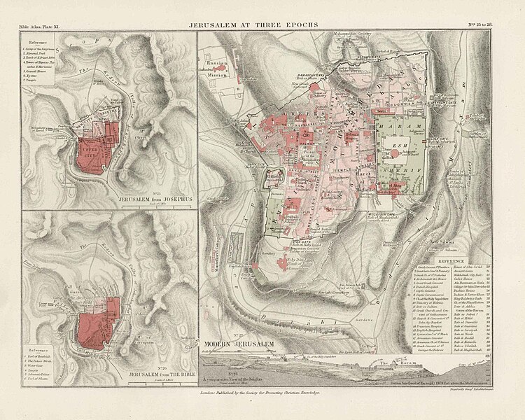
[edit]| Samuel Clark: Jerusalem at three epochs
( |
||||||||||||||||||||||||
|---|---|---|---|---|---|---|---|---|---|---|---|---|---|---|---|---|---|---|---|---|---|---|---|---|
| Artist |
|
|||||||||||||||||||||||
| Title |
Jerusalem at three epochs |
|||||||||||||||||||||||
| Publisher |
Society for Promoting Christian Knowledge |
|||||||||||||||||||||||
| Description |
Jerusalem at three epochs.. |
|||||||||||||||||||||||
| Language | English | |||||||||||||||||||||||
| Publication date | 1868 | |||||||||||||||||||||||
| Medium | 1 online resource (1 map). | |||||||||||||||||||||||
| Collection |
|
|||||||||||||||||||||||
| Current location |
|
|||||||||||||||||||||||
| Place of publication | London | |||||||||||||||||||||||
| search Merhav catalog | London | |||||||||||||||||||||||
| Notes | Digital image of the original in Amir Cahanovitc Collection, Israel. ACC 1614-9.; Digital image received from donor.; From: The bible atlas of maps and plans to illustrate the geography and topography of the old and new testaments and the Apocrypha, with explanatory notes, By Samuel Clark, M. A., Vicar of Bredwardine, Hereford. Also a complete index of the geographical names in the English Bible, by George Grove.; Insets: No. 25. Jerusalem from Josephus, No. 26. Jerusalem from the Bible, No. 28. A comparative view of the heights. | |||||||||||||||||||||||
| IE PID | IE36567313 | |||||||||||||||||||||||
| Rosetta filename | FL36567316 | |||||||||||||||||||||||
| NNL item ID (P3959) | 990039088210205171 | |||||||||||||||||||||||
| Depicts | Jerusalem – city in the Middle East, holy to the three Abrahamic religions | |||||||||||||||||||||||
| search Merhav catalog | Jerusalem, English, Samuel Clark | |||||||||||||||||||||||
| search Merhav catalog | Modern JerusalemJerusalemSociety for Promoting Christian Knowledge | |||||||||||||||||||||||
| Source/Photographer |
|
|||||||||||||||||||||||
| Other versions | ||||||||||||||||||||||||
| Jpg / Tif version |
|
|||||||||||||||||||||||

.jpg)

.jpg&action=edit§ion=1)
Licensing
[edit].jpg&action=edit§ion=2)
The copyright situation of this work is theoretically uncertain, because in the country of origin copyright lasts 70 years after the death of the author, and the date of the author's death is unknown. However, the date of creation of the work was over 120 years ago, and it is thus a reasonable assumption that the copyright has expired (see here for the community discussion). Do not use this template if the date of death of the author is known.
| |
| This file has been identified as being free of known restrictions under copyright law, including all related and neighboring rights. | |
File history
Click on a date/time to view the file as it appeared at that time.
| Date/Time | Thumbnail | Dimensions | User | Comment | |
|---|---|---|---|---|---|
| current | 11:00, 30 August 2023 | | 3,328 × 2,661 (4.45 MB) | Geagea (talk | contribs) | pattypan 22.03 |
You cannot overwrite this file.
File usage on Commons
The following page uses this file:
.jpg&oldid=797079646)