File:San Francisco Sanborn Insurance Map Atlas (5850051).jpg
Jump to navigation
Jump to search

Size of this preview: 800 × 553 pixels. Other resolutions: 320 × 221 pixels | 640 × 442 pixels | 1,024 × 707 pixels | 1,280 × 884 pixels | 2,560 × 1,768 pixels | 12,402 × 8,566 pixels.
Original file (12,402 × 8,566 pixels, file size: 24.79 MB, MIME type: image/jpeg)
Captions
Captions
Add a one-line explanation of what this file represents
Summary
[edit].jpg&action=edit§ion=1)
| Description |
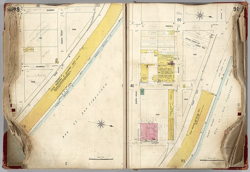
English: San Francisco Sanborn Insurance Map Atlas. Maps in full color with detailed legend including firehouses, stables, elevators, chimneys, steam boilers, firewalls, doorways, etc. Bound in 1.5 cm thick heavy cardboard boards with what appears to be thin black fabric, red leather quarter binding and corner reinforcement (very worn), and worn gray cloth labeled on the front in black lettering, "San Francisco CALIFORNIA. VOL. 1". Published by Sanborn-Perris Map Co. Limited, 115 Broadway, New York. Scale: 50 Ft. to an Inch.
Français : San Francisco Sanborn Insurance Map Atlas. Cartes en couleur avec légende détaillée comprenant les casernes de pompiers, les écuries, les ascenseurs, les cheminées, les chaudières à vapeur, les pare-feu, les portes, etc. Relié dans des cartons épais de 1,5 cm d'épaisseur avec ce qui semble être un fin tissu noir, une reliure en cuir rouge et un renfort de coin (très usé), et un tissu gris usé étiqueté au recto en lettres noires, "San Francisco CALIFORNIA. VOL. 1" . Publié par Sanborn-Perris Map Co. Limited, 115 Broadway, New York. Échelle : 50 pieds pour un pouce. |
| Date | |
| Source | list, main |
| Author | Sanborn-Perris Map Company, Limited |
Licensing
[edit].jpg&action=edit§ion=2)
|
This is a faithful photographic reproduction of a two-dimensional, public domain work of art. The work of art itself is in the public domain for the following reason:
The official position taken by the Wikimedia Foundation is that "faithful reproductions of two-dimensional public domain works of art are public domain".
This photographic reproduction is therefore also considered to be in the public domain in the United States. In other jurisdictions, re-use of this content may be restricted; see Reuse of PD-Art photographs for details. | ||||
File history
Click on a date/time to view the file as it appeared at that time.
| Date/Time | Thumbnail | Dimensions | User | Comment | |
|---|---|---|---|---|---|
| current | 12:12, 1 August 2023 | | 12,402 × 8,566 (24.79 MB) | YannBot (talk | contribs) | == {{int:filedesc}} == {{Information |Description={{en|1=''San Francisco Sanborn Insurance Map Atlas''. Maps in full color with detailed legend including firehouses, stables, elevators, chimneys, steam boilers, firewalls, doorways, etc. Bound in 1.5 cm thick heavy cardboard boards with what appears to be thin black fabric, red leather quarter binding and corner reinforcement (very worn), and worn gray cloth labeled on the front in black lettering, "San Francisco CALIFORNIA. VOL. 1". Published... |
You cannot overwrite this file.
File usage on Commons
There are no pages that use this file.
.jpg&oldid=788988698)