File:Sanba Sept 17 2012 0430Z (gallery).jpg
Jump to navigation
Jump to search

Size of this preview: 457 × 600 pixels. Other resolutions: 183 × 240 pixels | 366 × 480 pixels | 585 × 768 pixels | 780 × 1,024 pixels | 1,560 × 2,048 pixels | 6,400 × 8,400 pixels.
Original file (6,400 × 8,400 pixels, file size: 7.58 MB, MIME type: image/jpeg)
Captions
Captions
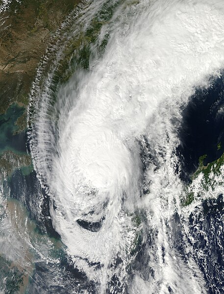
Tropical Storm Sanba (17W) over Korea
Summary[edit]
.jpg&action=edit§ion=1)
| Description |
English: When Sanba made landfall in South Korea on September 17, 2012, it brought heavy rains and high winds, downed power lines, grounded hundreds of flights, and halted ferry services. One person was killed and another was injured in landslides caused by the storm.
The Moderate Resolution Imaging Spectroradiometer (MODIS) on NASA’s Aqua satellite captured this natural-color image on September 17, when Sanba’s clouds engulfed the Korean Peninsula. The same day, the U.S. Navy’s Joint Typhoon Warning Center reported that the storm’s sustained winds had dropped to 45 knots (85 kilometers per hour). The projected storm track showed Sanba continuing to move toward the China-Russia border. |
| Date | |
| Source | https://lance.modaps.eosdis.nasa.gov/cgi-bin/imagery/single.cgi?image=Sanba.A2012261.0430.2km.jpg |
| Author | National Aeronautics and Space Administration, LANCE/EOSDIS Rapid Response, captured on Aqua satellite |
| Metadata | https://lance.modaps.eosdis.nasa.gov/cgi-bin/imagery/single.cgi?metadata=Sanba.A2012261.0430.txt |
| Satellite | Aqua |
| Camera location | | View this and other nearby images on: OpenStreetMap |
|---|
.jpg¶ms=038.000000_N_0129.400000_E_globe:Earth_type:camera__&language=en)
Licensing[edit]
.jpg&action=edit§ion=2)
| This file is in the public domain in the United States because it was solely created by NASA. NASA copyright policy states that "NASA material is not protected by copyright unless noted". (See Template:PD-USGov, NASA copyright policy page or JPL Image Use Policy.) | ||
 |
Warnings:
|
File history
Click on a date/time to view the file as it appeared at that time.
| Date/Time | Thumbnail | Dimensions | User | Comment | |
|---|---|---|---|---|---|
| current | 07:24, 23 August 2023 | | 6,400 × 8,400 (7.58 MB) | Nino Marakot (talk | contribs) | Uploaded a work by National Aeronautics and Space Administration, LANCE/EOSDIS Rapid Response, captured on Aqua satellite from https://lance.modaps.eosdis.nasa.gov/cgi-bin/imagery/single.cgi?image=Sanba.A2012261.0430.2km.jpg with UploadWizard |
You cannot overwrite this file.
File usage on Commons
There are no pages that use this file.
File usage on other wikis
The following other wikis use this file:
- Usage on en.wikipedia.org
.jpg&oldid=795744615)