File:Sanitation and Drinking Water Global Map.jpg
Jump to navigation
Jump to search

Size of this preview: 776 × 600 pixels. Other resolutions: 311 × 240 pixels | 621 × 480 pixels | 994 × 768 pixels | 1,280 × 989 pixels | 2,560 × 1,978 pixels | 3,300 × 2,550 pixels.
Original file (3,300 × 2,550 pixels, file size: 849 KB, MIME type: image/jpeg)
Captions
Captions
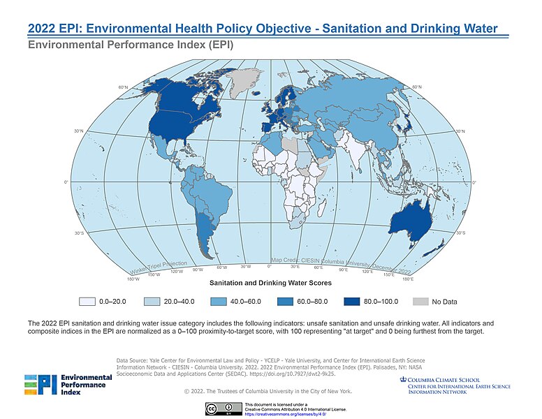
Global map depicting the international sanitation and drinking water scores.
Summary
[edit]
| Description |
English: The 2022 EPI sanitation and drinking water issue category includes the following indicators: unsafe sanitation and unsafe drinking water. All indicators and composite indices in the EPI are normalized as a 0–100 proximity-to-target score, with 100 representing "at target" and 0 being furthest from the target. |
| Date | |
| Source | 2020 EPI: Environmental Health Objective - Waste Management |
| Author | SEDACMaps |
Licensing
[edit]
This file is licensed under the Creative Commons Attribution 2.0 Generic license.
- You are free:
- to share – to copy, distribute and transmit the work
- to remix – to adapt the work
- Under the following conditions:
- attribution – You must give appropriate credit, provide a link to the license, and indicate if changes were made. You may do so in any reasonable manner, but not in any way that suggests the licensor endorses you or your use.
| This image, originally posted to Flickr, was reviewed on 30 April 2024 by the administrator or reviewer Abzeronow, who confirmed that it was available on Flickr under the stated license on that date. |
This file is licensed under the Creative Commons Attribution 4.0 International license.
- You are free:
- to share – to copy, distribute and transmit the work
- to remix – to adapt the work
- Under the following conditions:
- attribution – You must give appropriate credit, provide a link to the license, and indicate if changes were made. You may do so in any reasonable manner, but not in any way that suggests the licensor endorses you or your use.
File history
Click on a date/time to view the file as it appeared at that time.
| Date/Time | Thumbnail | Dimensions | User | Comment | |
|---|---|---|---|---|---|
| current | 23:42, 23 April 2024 | | 3,300 × 2,550 (849 KB) | Girlie1366 (talk | contribs) | Uploaded a work by SEDACMaps from Openverse.org with UploadWizard |
You cannot overwrite this file.
File usage on Commons
There are no pages that use this file.
File usage on other wikis
The following other wikis use this file:
- Usage on en.wikipedia.org