File:Santa Marta Maracaibo 1753.jpg
Jump to navigation
Jump to search
No higher resolution available.
Santa_Marta_Maracaibo_1753.jpg (730 × 499 pixels, file size: 322 KB, MIME type: image/jpeg)
Captions
Captions
Add a one-line explanation of what this file represents
Summary[edit]
| Description |
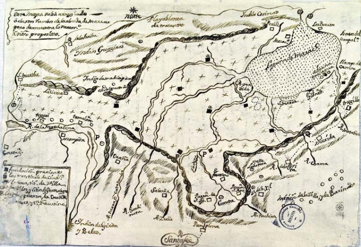
Español: Mapa de la zona comprendida entre la laguna de Maracaibo y la Provincia de Santa Marta, en el que se señalan accidentes geográficos, los pueblos, caminos y tierras de los indios comarcanos. 1753 |
| Date | |
| Source | Archivo General de la Nación, mapoteca 4, ref. 599A Bis. |
| Author | Unknown author |
Licensing[edit]
The copyright situation of this work is theoretically uncertain, because in the country of origin copyright lasts 80 years after the death of the author, and the date of the author's death is unknown. However, the date of creation of the work was over 130 years ago, and it is thus a reasonable assumption that the copyright has expired (see here for the community discussion). Do not use this template if the date of death of the author is known.
| |
| This file has been identified as being free of known restrictions under copyright law, including all related and neighboring rights. | |
File history
Click on a date/time to view the file as it appeared at that time.
| Date/Time | Thumbnail | Dimensions | User | Comment | |
|---|---|---|---|---|---|
| current | 22:07, 11 March 2021 | | 730 × 499 (322 KB) | Tuhondre (talk | contribs) | Uploaded a work by Archivo General de la Nación from Archivo General de la Nación, mapoteca 4, ref. 599A Bis. with UploadWizard |
You cannot overwrite this file.
File usage on Commons
There are no pages that use this file.
File usage on other wikis
The following other wikis use this file:
- Usage on es.wikipedia.org