File:Saskatchewan-census area 01.png
Jump to navigation
Jump to search

Size of this preview: 347 × 600 pixels. Other resolutions: 139 × 240 pixels | 379 × 655 pixels.
Original file (379 × 655 pixels, file size: 85 KB, MIME type: image/png)
Captions
Captions
Add a one-line explanation of what this file represents
Summary
[edit]
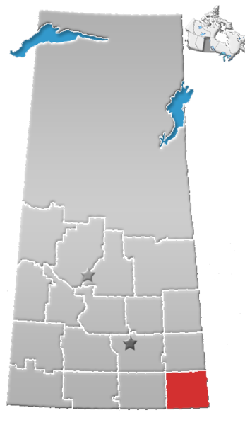
| Description | Saskatchewan census area No. 01 |
| Date | (UTC) |
| Source |
This file was derived from: SK-census divisions.png:  |
| Author |
|
| This is a retouched picture, which means that it has been digitally altered from its original version. The original can be viewed here: SK-census divisions.png:
|
Licensing
[edit]
I, the copyright holder of this work, hereby publish it under the following license:
| I, the copyright holder of this work, release this work into the public domain. This applies worldwide. In some countries this may not be legally possible; if so: I grant anyone the right to use this work for any purpose, without any conditions, unless such conditions are required by law. |
Original upload log
[edit]
This image is a derivative work of the following images:
- File:SK-census_divisions.png licensed with PD-self
Uploaded with derivativeFX
File history
Click on a date/time to view the file as it appeared at that time.
| Date/Time | Thumbnail | Dimensions | User | Comment | |
|---|---|---|---|---|---|
| current | 20:37, 1 August 2012 | | 379 × 655 (85 KB) | Feuerst (talk | contribs) | == {{int:filedesc}} == {{Information |Description=Saskatchewan census area No. 01 |Source={{Derived from|SK-census_divisions.png|display=50}} |Date=2012-08-01 20:31 (UTC) |Author=*File:SK-census_divisions.png: Qyd *derivative work: ... |
You cannot overwrite this file.
File usage on Commons
There are no pages that use this file.
File usage on other wikis
The following other wikis use this file:
- Usage on de.wikipedia.org
- Usage on en.wikipedia.org
- Fertile, Saskatchewan
- Estevan
- Redvers, Saskatchewan
- Oxbow, Saskatchewan
- Glen Ewen
- Wawota
- Alameda, Saskatchewan
- Alida, Saskatchewan
- Antler, Saskatchewan
- Arcola, Saskatchewan
- Division No. 1, Saskatchewan
- Rural Municipality of Storthoaks No. 31
- Rural Municipality of Walpole No. 92
- Rural Municipality of Argyle No. 1
- Gainsborough, Saskatchewan
- Rural Municipality of Antler No. 61
- Bellegarde, Saskatchewan
- Heward, Saskatchewan
- Storthoaks
- Carlyle, Saskatchewan
- Bienfait
- Lampman
- Maryfield, Saskatchewan
- Carnduff
- Carievale
- Stoughton, Saskatchewan
- Rural Municipality of Tecumseh No. 65
- Fairlight, Saskatchewan
- Forget, Saskatchewan
- Frobisher, Saskatchewan
- Kennedy, Saskatchewan
- Kenosee Lake, Saskatchewan
- Kisbey
- Manor, Saskatchewan
- North Portal
- Benson, Saskatchewan
- Bryant, Saskatchewan
- Cannington Lake
- Corning, Saskatchewan
- Wauchope, Saskatchewan
- Rural Municipality of Mount Pleasant No. 2
- Rural Municipality of Enniskillen No. 3
- Northgate, Saskatchewan
- Rural Municipality of Coalfields No. 4
- Rural Municipality of Estevan No. 5
- Roche Percee
- Rural Municipality of Reciprocity No. 32
- Rural Municipality of Moose Creek No. 33
- Rural Municipality of Browning No. 34
View more global usage of this file.