File:Satellite Sees An Atlantic Triple Tropical Threat - Flickr - NASA Goddard Photo and Video.jpg

Исходный файл (3072 × 3072 пкс, размер файла: 1,33 МБ, MIME-тип: image/jpeg)
Краткие подписи
Краткие подписи
Краткое описание
[править]
| Описание |
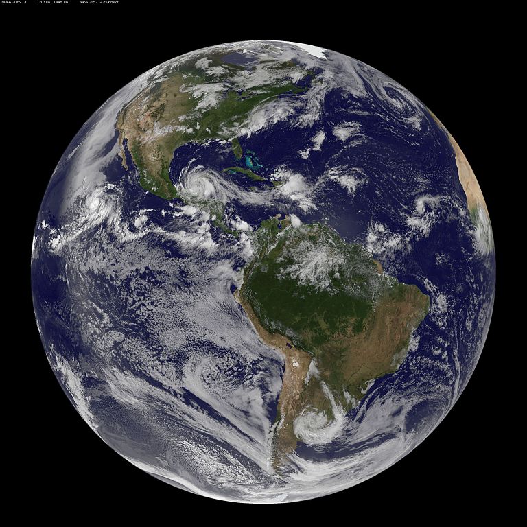
Image acquired August 8, 2012 There are three storms in the Atlantic Ocean basin on August 8, 2012 that have caught forecasters attention at the National Hurricane Center and they were captured in one image from NOAA's GOES-13 satellite. To the west lies Tropical Storm Ernesto, currently moving over Mexico. At 11:15 p.m. EDT on Tuesday, August 7, Belize radar indicated Ernesto made landfall along the southern Yucatan coast near Mahahual, Mexico as a category one hurricane with maximum sustained winds near 85 mph (140 kmh). At 10 a.m. EDT on August 8, Ernesto's maximum sustained winds were near 50 mph (85 kmh) and it was 265 miles (425 km) east of Coatzacoalcos, Mexico, near 18.7 North and 90.4 West. The National Hurricane Center expects Ernesto's center to emerge into the extreme southern Bay Of Campeche tonight where it is expected to re-strengthen. The second area forecasters are eyeing is that of post-tropical storm Florence's remains, located about 450 miles east of the Northern Leeward Islands. The remnants are still producing thunderstorms and showers, although it remains disorganized. The National Hurricane Center gives that low pressure area a "near zero" chance of becoming a tropical depression over the next couple of days. Farthest east lies a low pressure area associated with a tropical wave in the eastern Atlantic. It is about 700 miles west-southwest of the Cape Verde Islands and has a 30 percent chance of becoming a tropical depression in the next two days, according to the National Hurricane Center. Rob Gutro, NASA Goddard Space Flight Center NASA Goddard Space Flight Center enables NASA’s mission through four scientific endeavors: Earth Science, Heliophysics, Solar System Exploration, and Astrophysics. Goddard plays a leading role in NASA’s accomplishments by contributing compelling scientific knowledge to advance the Agency’s mission. Follow us on Twitter Like us on Facebook Find us on Instagram |
| Дата | |
| Источник | Satellite Sees An Atlantic Triple Tropical Threat |
| Автор | NASA Goddard Space Flight Center from Greenbelt, MD, USA |
Лицензирование
[править]
- Вы можете свободно:
- делиться произведением – копировать, распространять и передавать данное произведение
- создавать производные – переделывать данное произведение
- При соблюдении следующих условий:
- атрибуция – Вы должны указать авторство, предоставить ссылку на лицензию и указать, внёс ли автор какие-либо изменения. Это можно сделать любым разумным способом, но не создавая впечатление, что лицензиат поддерживает вас или использование вами данного произведения.
| Это изображение изначально опубликовано на Flickr участником проекта NASA Goddard Photo and Video по ссылке https://www.flickr.com/photos/24662369@N07/7741851934. Оно было досмотрено 17 августа 2012 роботом FlickreviewR, который подтвердил, что изображение лицензировано в соответствии с условиями cc-by-2.0. |
| Этот файл находится в общественном достоянии (англ. public domain), так как он был создан NASA (Национальным управлением по аэронавтике и исследованию космического пространства). Политика авторского права NASA гласит, что «Материал NASA не защищается авторским правом, если не указано иное». (См. Template:PD-USGov, страницу политики авторского права NASA или политику использования изображений JPL.) | ||
 |
Предупреждения:
|
История файла
Нажмите на дату/время, чтобы увидеть версию файла от того времени.
| Дата/время | Миниатюра | Размеры | Участник | Примечание | |
|---|---|---|---|---|---|
| текущий | 19:42, 17 августа 2012 | | 3072 × 3072 (1,33 МБ) | Werieth (обсуждение | вклад) | == {{int:filedesc}} == {{Information |Description=Image acquired August 8, 2012 There are three storms in the Atlantic Ocean basin on August 8, 2012 that have caught forecasters attention at the National Hurricane Center and they were captured in one ... |
Вы не можете перезаписать этот файл.
Использование файла
Следующие 3 страницы используют этот файл:
Глобальное использование файла
Данный файл используется в следующих вики:
- Использование в uk.wikipedia.org